Category:1895 maps of Louisiana
Jump to navigation
Jump to search
States of the United States: California · Connecticut · Florida · Georgia · Illinois · Iowa · Kentucky · Louisiana · Maine · Maryland · Massachusetts · Michigan · Minnesota · Mississippi · Missouri · Nevada · New Jersey · New York · Ohio · Oklahoma · Oregon · Pennsylvania · Rhode Island · South Carolina · Tennessee · Texas · Utah · Vermont · Virginia · Washington · West Virginia · Wisconsin · Wyoming – Washington, D.C.
| ← 1890 1891 1892 1893 1894 1895 1896 1898 1899 |
Subcategories
This category has the following 4 subcategories, out of 4 total.
Media in category "1895 maps of Louisiana"
The following 15 files are in this category, out of 15 total.
-

-
 Sanborn Fire Insurance Map from Crowley, Acadia Parish, Louisiana. LOC sanborn03298 001-1.tif 6,450 × 7,650; 141.17 MB
-

-
 Sanborn Fire Insurance Map from Crowley, Acadia Parish, Louisiana. LOC sanborn03298 001-2.tif 6,450 × 7,650; 141.17 MB
-
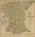 Map of the Parish of East Baton Rouge, Louisiana LOC 2012592319.jpg 13,062 × 13,856; 21.45 MB
-
 Map of the Parish of East Baton Rouge, Louisiana LOC 2012592319.tif 13,062 × 13,856; 517.81 MB
-
 Mississippi River Sheet 1895 Plaquemines Parish Louisiana.jpg 7,081 × 4,113; 9.12 MB
-

-

-

-

-

-
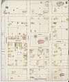
 Sanborn Fire Insurance Map from Abbeville, Vermilion Parish, Louisiana. LOC sanborn03264 001-1.tif 6,450 × 7,650; 141.17 MB
-
-
 Sanborn Fire Insurance Map from Abbeville, Vermilion Parish, Louisiana. LOC sanborn03264 001-2.tif 6,450 × 7,650; 141.17 MB


