Category:1867 maps of Canada
Jump to navigation
Jump to search
Countries of North America: Belize · Canada · United States of America‡
‡: partly located in North America
‡: partly located in North America
| ← 1860 1861 1862 1863 1864 1866 1867 1868 1869 → |
English: Maps of Canada from 1867 or related to Canada in 1867
Français : Les cartes du Canada de 1867 ou se rapportant au Canada en 1867
Media in category "1867 maps of Canada"
The following 4 files are in this category, out of 4 total.
-
 Canada 1867 Federal Election.svg 1,084 × 920; 297 KB
-
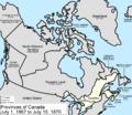 Canada provinces 1867-1870.png 1,000 × 864; 61 KB
-
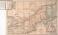
 Map of the Eastern British Provinces in North America at the time of Confederation 1867.jpg 1,600 × 1,300; 2.56 MB
-