User talk:Furfur/Archive 2
 | This is an archive of past discussions. Do not edit the contents of this page. If you wish to start a new discussion or revive an old one, please do so on the current talk page. |
| Archive 1 | Archive 2 | Archive 3 |
Hello, Furfur,
Your are creating very nice maps, and I have noticed that some of these maps are in Chinese.
Can you add Chinese labels?
In File:Metro map of China.svg, Wenzhou needs to be added in because it has a metro network.
Please also check, if other Chinese cities with metro networks are also missing.
Here are sources:
If you can't, thank you anyway.
Yours sincerely, Maphobbyist (talk) 16:50, 2 August 2019 (UTC)
- Hello @Maphobbyist: ok, I will upload a map that includes Wenzhou. Please tell me if something else needs to be changed in this map. --Furfur ⁂ Diskussion 18:12, 2 August 2019 (UTC)
- Thank you for your reply. Unfortunately, I don't know Chinese. I only realized that Wenzhou was missing, because of its geographical location. There might be other Chinese cities with metro networks which are missing.
- However all Chinese cities which have metro networks in service or under construction, are shown in the English language map File:Greater China Rapid Transit.svg which could help in locating missing cities in File:Metro map of China.svg, if there are any.
- Can you also update File:Greater China Rapid Transit.svg where only the color of the names and the dots of Urumqi, Xiamen, Shijiazhuang, Jinan, Guiyang, Lanzhou, Fuzhou, Taoyuan, Wenzhou, Nanning and Dongguan need to be changed from red (under construction) to green (operational). These cities' metro networks are in service.
- Sources:
- That will be all.
- @Maphobbyist: ok, done. Hopefully there are no mistakes ... --Furfur ⁂ Diskussion 19:26, 2 August 2019 (UTC)
- No cities are missing and there are no mistakes. Thank you very much for the updates! Maphobbyist (talk) 19:43, 2 August 2019 (UTC)
 |
File:All India Forward Bloc.svg has been marked as a possible copyright violation. Wikimedia Commons only accepts free content—that is, images and other media files that can be used by anyone, for any purpose. Traditional copyright law does not grant these freedoms, and unless noted otherwise, everything you find on the web is copyrighted and not permitted here. For details on what is acceptable, please read Commons:Licensing. You may also find Commons:Copyright rules useful, or you can ask questions about Commons policies at the Commons:Help desk. If you are the copyright holder and the creator of the file, please read Commons:But it's my own work! for tips on how to provide evidence of that.
The file you added has been deleted. If you have written permission from the copyright holder, please have them send us a free license release via COM:VRT. If you believe that the deletion was not in accordance with policy, you may request undeletion. (It is not necessary to request undeletion if using VRT; the file will be automatically restored at the conclusion of the process.) Warning: Wikimedia Commons takes copyright violations very seriously and persistent violators will be blocked from editing.
|
--EugeneZelenko (talk) 14:16, 24 August 2019 (UTC)
- @EugeneZelenko: No discussion at all for a file that existed and was used on several pages without any objectives for several years? That's very sportive! --Furfur ⁂ Diskussion 14:22, 24 August 2019 (UTC)
- This is definitely non-trivial logo and copyrights belong to original creator or political party. Such files should not be uploaded without explicit permissions from copyrights holder. --EugeneZelenko (talk) 14:26, 24 August 2019 (UTC)
File:Lienchangadm.svg
A few problems with your current version of

: Liangdao = Beigan Township (should be blue not green) Daqin = Daqiu Donju = Dongju There are some islands in your map which may be part of the PRC. --Geographyinitiative (talk) 06:00, 19 September 2019 (UTC)

In this map, Lieju ought to be spelled Lieyu. --Geographyinitiative (talk) 06:02, 19 September 2019 (UTC)
- Hello Geographyinitiative thanks for you notification. Iwill correct this! --Furfur ⁂ Diskussion 07:01, 19 September 2019 (UTC)
- @Geographyinitiative: I hope it's ok now. --Furfur ⁂ Diskussion 08:29, 19 September 2019 (UTC)
- I really like your maps and am seriously considering using them on the English language Wikipedia. The maps we have now are like cartoons. However, I still have some minor issues with your maps. I will do further research and get back to you later. Geographyinitiative (talk) 11:22, 19 September 2019 (UTC)
- Yes, of course, please feel free to do so. If there are any errors, they should be corrected. --Furfur ⁂ Diskussion 13:18, 19 September 2019 (UTC)
- Hello again. Are there any errors left in this map? How would you know if there were any errors? What is your source on which islands are part of Matsu and which islands are not? Thanks. --Geographyinitiative (talk) 22:13, 21 October 2019 (UTC)
- Yes, of course, please feel free to do so. If there are any errors, they should be corrected. --Furfur ⁂ Diskussion 13:18, 19 September 2019 (UTC)
- I really like your maps and am seriously considering using them on the English language Wikipedia. The maps we have now are like cartoons. However, I still have some minor issues with your maps. I will do further research and get back to you later. Geographyinitiative (talk) 11:22, 19 September 2019 (UTC)
- @Geographyinitiative: I hope it's ok now. --Furfur ⁂ Diskussion 08:29, 19 September 2019 (UTC)
- Hello Geographyinitiative thanks for you notification. Iwill correct this! --Furfur ⁂ Diskussion 07:01, 19 September 2019 (UTC)
Copyright status: File:Logo Province de Luxembourg.svg
Copyright status: File:Logo Province de Luxembourg.svg
| This media may be deleted. |
Thanks for uploading File:Logo Province de Luxembourg.svg. I notice that the file page either doesn't contain enough information about the license or it contains contradictory information about the license, so the copyright status is unclear.
If you created this file yourself, then you must provide a valid copyright tag. For example, you can tag it with {{self|GFDL|cc-by-sa-all}} to release it under the multi-license GFDL plus Creative Commons Attribution-ShareAlike All-version license or you can tag it with {{PD-self}} to release it into the public domain. (See Commons:Copyright tags for the full list of license tags that you can use.) If you did not create the file yourself or if it is a derivative of another work that is possibly subject to copyright protection, then you must specify where you found it (e.g. usually a link to the web page where you got it), you must provide proof that it has a license that is acceptable for Commons (e.g. usually a link to the terms of use for content from that page), and you must add an appropriate license tag. If you did not create the file yourself and the specific source and license information is not available on the web, you must obtain permission through the VRT system and follow the procedure described there. Note that any unsourced or improperly licensed files will be deleted one week after they have been marked as lacking proper information, as described in criteria for deletion. If you have uploaded other files, please confirm that you have provided the proper information for those files, too. If you have any questions about licenses please ask at Commons:Village pump/Copyright or see our help pages. Thank you. |
Magog the Ogre (talk) (contribs) 14:25, 29 September 2019 (UTC)
Hello
Since you had created a vector version of File:Yunnan admin.svg, I would like to ask for a favour, can you vectorize other provinces in PRC as mostly provinces are still in png form. And then, green colour is for city core district area while cyan is for en:County-level city, danke.*angys* (talk) 14:20, 26 October 2019 (UTC)
- Hello @*angys*: I really would like to do this, and in fact I also created maps of Anhui (安徽省) and Guangdong (广东省). However, it only makes sense to create SVG maps if you have a high quality raster image, to be used as a template. Regrettably, nearly all the images in the Commons are relatively low quality and not suitable for creating higher resolution SVG maps. Perhaps you know any good sources? Did you detect any errors in the green coloring? 祝好 --Furfur ⁂ Diskussion 14:39, 26 October 2019 (UTC)
- Maybe yes, Anhui one got for Tongling city (at 8 and 16 as those enclaves are copper mineshaft), and Guangdong one should change some colour (you can compare with the older version)
- Fujian (File:Locator map of Fuqing.svg or File:China Fujian location map.svg)
- Hebei File:ChinaHebeiXingtai.svg
- Jiangxi File:Jiangxi.svg
- Xinjang File:China Xinjiang Kashgar.svg(refer to Xinjiang prfc map2.png)
- Tibet File:Tibet&neighbors Locator map.svg, some borders were outdated
- Gansu (mostly prefectures own its svg maps) Category:Maps of Gansu
- Hubei File:China Hubei location map.svg
- Hunan File:Hunan China map EN.svg
- Shandong File:China Shandong location map.svg
- Qinghai File:Hoh Xi-Karte.svg
- Jilin File:China Jilin Baishan.svg
Hope these files can help you.*angys* (talk) 16:18, 26 October 2019 (UTC)
- Hello @*angys*: I compared the Guangdong map with the older map, but could not detect any differences in coloring. Can you please give me a hint? And when it comes to Anhui: this is exactly what I mean. If you want to be precise and also display tiny enclaves correctly you need a high resolution map as a template. For example this map of Jilin is nice but does not have a very high resolution. I am not sure if it really would be an improvement, if I remade it as an SVG map. The details of the map are not getting better by this. Or, let's say Fujian: of course File:China Fujian location map.svg is a very fine map, but it does not contain prefecture borders. Using this map as a base I still would have to rely on low resolution maps such as this one. So the result would be a map of Fujian province with detailed and accurate outer borders but imprecise inner borders – a kind of pseudo precision.
But I have seen that User:Chk2011 is very active and has recently created nice SVG prefecture maps of Gansu. Perhaps you could also ask him/her if he/she is willing to create a map of Gansu province and possibly other provinces? --Furfur ⁂ Diskussion 17:11, 26 October 2019 (UTC)
- Hello @*angys*: I compared the Guangdong map with the older map, but could not detect any differences in coloring. Can you please give me a hint? And when it comes to Anhui: this is exactly what I mean. If you want to be precise and also display tiny enclaves correctly you need a high resolution map as a template. For example this map of Jilin is nice but does not have a very high resolution. I am not sure if it really would be an improvement, if I remade it as an SVG map. The details of the map are not getting better by this. Or, let's say Fujian: of course File:China Fujian location map.svg is a very fine map, but it does not contain prefecture borders. Using this map as a base I still would have to rely on low resolution maps such as this one. So the result would be a map of Fujian province with detailed and accurate outer borders but imprecise inner borders – a kind of pseudo precision.
Karte Map_France_1477-de.svg
Hallo Furfur. Du hattest 2010 die Karte von Frankreich im Jahre 1477 erstellt. Die ist auch sehr informativ, ich wollte nur auf zwei Kleinigkeiten hinweisen, die evtl. korrigiert werden müssen: Die Gft. Provence wurde zwar von einer Nebenlinie der Valois regiert, war aber 1477 noch Lehen des Heiligen Römischen Reiches - erst mit dem Tod des Grafen Charles fiel die Provence 1481 an die französische Krone und gehörte von da an nicht mehr zum Reich. Die rote Grenzlinie müsste für 1477 also westlich der Grafschaft gezogen werden (wobei wohl auch das päpstliche Venaissin korrekterweise nicht zu Frankreich gezählt werden dürfte, wohl aber das Fstm. Orange). Auf der anderen Seite gehörte das Roussillon von 1462 bis 1493 zu Frankreich, genau genommen als Pfandbesitz, war aber in jedem Fall französisch besetzt und kontrolliert. --Proofreader (talk) 15:02, 13 December 2019 (UTC)
- Hallo Proofreader, vielen Dank für das genaue Hinsehen. Ich bin nicht der eigentliche Autor der Karte (darauf hatte ich in der Dateibeschreibung hingeweisen), sondern das ist wohl Benutzer ZigeunerAlt, der aber wohl nicht mehr aktiv ist. Seine Karte beruhte auf der Karte File:France XVe siècle.jpg. Diese Karte wiederum ist nur zeitlich unscharf gekennzeichnet als “Frankreich im späten 15. Jahrhundert”. Auf dieser Karte heißt es, dass die Provence 1486 an Frankreich kam. Das Venaissin sollte in der Tat aus Frankreich ausgegliedert werden. Das Roussillon finde ich eigentlich durch die blaue Schraffur hinreichend gut charakterisiert. Ganz blau färben würde ich es nicht, da es ja nur Pfandbesitz war und nicht eigentlicher Teil der Krondomäne. Vielleicht könnte man das Problem mit der Provence so lösen, dass die Datei umbenannnt wird in Map France 1498-de.svg (im Artikel über die Provence heißt es, dass die Provence 1498 Teil der Krondomäne wurde). --Furfur ⁂ Diskussion 18:11, 13 December 2019 (UTC)
Gold, Silver, Bronze Medals for Indonesian version
Hello! I just sumbled upon your works: Asiatischer Monat 2019 Goldmedaille.svg, Asiatischer Monat 2019 Silbermedaille.svg, & Asiatischer Monat 2019 Bronzemedaille.svg, and I am wondering if you could help me create these medals in Indonesian. Is it possible to do so? Thank you, ··· 🌸 Rachmat04 · ☕ 15:53, 16 December 2019 (UTC)
- Hello, I think that I could do that. Do you still want to use them (the contest is already over)? --Furfur ⁂ Diskussion 15:55, 16 December 2019 (UTC)
- Yes, I'll use that. It's still relevant for us. Here are the translation you may need:
- Wikipedia Asian Month 2019 = Bulan Asia Wikipedia 2019 (id)
- Gold medal = Medali emas (id)
- Silver medal = Medali perak (id)
- Bronze medal = Medali perunggu (id)
- Thank you for your help! ··· 🌸 Rachmat04 · ☕ 16:14, 16 December 2019 (UTC)
- Yes, I'll use that. It's still relevant for us. Here are the translation you may need:
- Hello, I think that I could do that. Do you still want to use them (the contest is already over)? --Furfur ⁂ Diskussion 15:55, 16 December 2019 (UTC)
- Hello @Rachmat04: I have created three medals. I hope they are useful.
-

emas -

perak -

perunggu


- Thank you very much! They are really useful. ··· 🌸 Rachmat04 · ☕ 13:10, 20 December 2019 (UTC)
Update request
Hello.
Can you add and/or color Changzhou and Xuzhou in File:Metro map of China.svg and File:Greater China Rapid Transit.svg (both cities appear in red in the big box where Shanghai is also located) because they were opened to service on 21 September and 28 September 2019 respectively.
Here are sources:
Yours sincerely, Maphobbyist (talk) 17:35, 26 November 2019 (UTC)
- Ok, done. --Furfur ⁂ Diskussion 20:23, 26 November 2019 (UTC)
- Thank you very much for the updates. One small request: Can you color the letter h of Changzhou and both location dots of Changzhou and Xuzhou in File:Greater China Rapid Transit.svg from red to green? Thank you. Maphobbyist (talk) 11:09, 27 November 2019 (UTC)
- ... hopefully it is correct now. --Furfur ⁂ Diskussion 19:22, 27 November 2019 (UTC)
- Yes, they are all green. Thank you very much. Maphobbyist (talk) 21:54, 27 November 2019 (UTC)
- ... hopefully it is correct now. --Furfur ⁂ Diskussion 19:22, 27 November 2019 (UTC)
Hello.
Sorry to bother you again, so soon after the last request. Can you add and/or color Macau in File:Metro map of China.svg and File:Greater China Rapid Transit.svg because it was opened to service on 10 December 2019. The metro systems of China are increasing so rapidly, both in numbers and in length and lines, it is incredible.
Here is the source:
Yours sincerely, Maphobbyist (talk) 15:38, 10 December 2019 (UTC)
- Ok, I have made the changes (Macau in traditional Chinese). --Furfur ⁂ Diskussion 17:57, 10 December 2019 (UTC)
- Thank you very much for both updates. Maphobbyist (talk) 06:35, 11 December 2019 (UTC)
Hello.
The number of metro systems in China seem to increase even more than once in a month! Can you add and/or color Honhot in File:Metro map of China.svg and File:Greater China Rapid Transit.svg because it was opened to service on 29 December 2019.
Here is the source:
I wish you a Happy New Year.
Yours sincerely, Maphobbyist (talk) 15:13, 31 December 2019 (UTC)
- Ok, done. --Furfur ⁂ Diskussion 15:42, 31 December 2019 (UTC)
- Thank you very much and a Happy New Year! Maphobbyist (talk) 15:59, 31 December 2019 (UTC)
Copyright status: File:2020ROCLY 2.svg
Copyright status: File:2020ROCLY 2.svg
| This media may be deleted. |
Thanks for uploading File:2020ROCLY 2.svg. I notice that the file page either doesn't contain enough information about the license or it contains contradictory information about the license, so the copyright status is unclear.
If you created this file yourself, then you must provide a valid copyright tag. For example, you can tag it with {{self|GFDL|cc-by-sa-all}} to release it under the multi-license GFDL plus Creative Commons Attribution-ShareAlike All-version license or you can tag it with {{PD-self}} to release it into the public domain. (See Commons:Copyright tags for the full list of license tags that you can use.) If you did not create the file yourself or if it is a derivative of another work that is possibly subject to copyright protection, then you must specify where you found it (e.g. usually a link to the web page where you got it), you must provide proof that it has a license that is acceptable for Commons (e.g. usually a link to the terms of use for content from that page), and you must add an appropriate license tag. If you did not create the file yourself and the specific source and license information is not available on the web, you must obtain permission through the VRT system and follow the procedure described there. Note that any unsourced or improperly licensed files will be deleted one week after they have been marked as lacking proper information, as described in criteria for deletion. If you have uploaded other files, please confirm that you have provided the proper information for those files, too. If you have any questions about licenses please ask at Commons:Village pump/Copyright or see our help pages. Thank you. |
Yours sincerely, Magog the Ogre (talk) (contribs) 02:06, 20 January 2020 (UTC)

|
File:Wuhan cases map.svg has been listed at Commons:Deletion requests so that the community can discuss whether it should be kept or not. We would appreciate it if you could go to voice your opinion about this at its entry.
If you created this file, please note that the fact that it has been proposed for deletion does not necessarily mean that we do not value your kind contribution. It simply means that one person believes that there is some specific problem with it, such as a copyright issue. Please see Commons:But it's my own work! for a guide on how to address these issues. |
Ratherous (talk) 11:13, 26 January 2020 (UTC)
Baby Trump image
@Furfur:
Hallo Furfur,
I would like to use your Baby Trump image in a new logo for political protest purposes. Do you have any objections?
I could send you an example...is there a way to email you directly? Or another way to send the image to you privately?
Fyi, your original Baby Trump image is located here: https://commons.wikimedia.org/wiki/File:Baby_Trump_blimp.svg
Vielen dank, Gosnow17 — Preceding unsigned comment added by Gosnow17 (talk • contribs) 19:23, 27 January 2020 (UTC)
- Hallo Gosnow17,
since I have published this work under a Creative Commons license, you can freely use the file as you want without asking and you do not need my permission for this. The image has been released to the public domain and I do not retain any ownership rights. The conditions for use are specified in the "Permission" section of the image. When you use the image in a logo, please don't overwrite the current file but upload the logo (if you want to upload it) as a separate file. Greetings --Furfur ⁂ Diskussion 20:22, 27 January 2020 (UTC)
- Hallo Furfur,
Okay, many thanks! Just wanted to be sure. Apologies for my unskillful use of Wikimedia talk-messaging.
Best regards,
Gosnow17 — Preceding unsigned comment was added by 24.149.39.189 (talk) 20:59, 27 January 2020 (UTC)
- No problem and good luck! --Furfur ⁂ Diskussion 21:02, 27 January 2020 (UTC)
China
Moin, im bild https://commons.m.wikimedia.org/wiki/File:ROC_Administrative_and_Claims-de.svg#mw-jump-to-license gibt es noch den typo "tiel des kachin-staates" EnTerbury (talk) 09:04, 10 April 2020 (UTC)
- Hallo EnTerbury, da hast Du ja die Karte sehr genau studiert! Ich korrigiere es gleich. Danke für den Hinweis. --Furfur ⁂ Diskussion 09:19, 10 April 2020 (UTC)
- In der tat, ich bin seit stunden auf der suche, was genau heute von der ROC beansprucht wird, finde aber nichts offizielles... Danke dir! EnTerbury (talk) 09:22, 10 April 2020 (UTC)
- @EnTerbury: De facto werden ja praktisch keine Ansprüche mehr auf das Festland allzu laut erhoben. Die Situation ist ja mittlerweile so dass die ROC um ihre eigene Existenz fürchten muss, da sie von der VRC bansprucht wird. Ganz interessant finde ich z. B. diese Karte aus dem Jahr 1979. Da sind tatsächlich noch alle damals de jure bestehenden Ansprüche eingezeichnet. Etliche Territorialansprüche (z. B. auf die Mongolei) wurden aber schon in den 1990ern offiziell aufgegeben. --Furfur ⁂ Diskussion 09:30, 10 April 2020 (UTC)
China, 2
Lieber Furfur, vielen Dank für die schöne Karte (https://commons.wikimedia.org/wiki/File:Volksrepublik_China_administrative_Gliederung.svg) - leider haben Sie "Kanton" mit "Chaozhou" übersetzt, es handelt sich aber um die Stadt "Guangzhou". Chaozhou ist weiter im Osten. Könnten Sie das ändern? Vielen Dank! 2A02:810A:1440:605A:24CD:6E2C:B60D:A76D 12:26, 11 April 2020 (UTC)
- Das ist korrekt, pardon, ein Flüchtigkeitsfehler – ich ändere es gleich! Vielen Dank für die Mitteilung! Grüße --Furfur ⁂ Diskussion 12:45, 11 April 2020 (UTC)
- ... ist korrigiert ... evtl. noch den Browser-Cache löschen, wenn es noch nicht sichtbar ist. --Furfur ⁂ Diskussion 12:50, 11 April 2020 (UTC)
|
|
File:Jammu-Kashmir-Ladakh.svg has been listed at Commons:Deletion requests so that the community can discuss whether it should be kept or not. We would appreciate it if you could go to voice your opinion about this at its entry.
If you created this file, please note that the fact that it has been proposed for deletion does not necessarily mean that we do not value your kind contribution. It simply means that one person believes that there is some specific problem with it, such as a copyright issue. Please see Commons:But it's my own work! for a guide on how to address these issues. |
2402:3A80:6A8:60FD:9943:6BDD:8464:26E2 11:23, 9 May 2020 (UTC)
Schwäbischer Reichskreis - fehlen Liechtenstein und Teile Vorarlbergs?
Hallo Furfur,
eine sehr schöne Karte! https://de.wikipedia.org/wiki/Reichskreis#/media/Datei:Map_of_the_Imperial_Circles_(1560)-de.svg
Im Text und in der Karte zum Schwäbischen Kreis gibt es allerdings folgenden Unterschied: "Die bedeutendsten Exklaven hingegen lagen .. in Vorarlberg und in Liechtenstein.", siehe https://de.wikipedia.org/wiki/Schwäbischer_Reichskreis
Kannst Du das in Deiner Karte entsprechend ändern? --2001:16B8:2260:3200:354B:2590:F742:1141 08:25, 28 May 2020 (UTC)
- Hallo 2001:16B8:2260:3200:354B:2590:F742:1141 (überlege Dir doch bitte, ob Du Dir nicht einen Benutzernamen zulegen willst, wenn Du hier ab und zu beitragen möchtest; dann kann man Dich auch persönlich ansprechen — es bleibt ja weiterhin anonym — so ist es für mich etwas, als spräche ich ins Leere),
die Karte ist nicht eigentlich von mir. Ich bin nur der Übersetzer, insofern muss ganz überwiegend das Lob an den eigentlichen Ersteller Sir Ian weitergegeben werden. Die Karte ist in den Teritorialgrenzen sicher recht grob und nicht sehr genau. Wahrscheinlich ließen sich noch weitere Detailfehler finden. Aber gut dass Du mich auf diese Karte (auch von Sir Iain) hinweist. Die werde ich mal als Basis nehmen, eine detailliertere Karte der Reichskreise zu erstellen. Grüße --Furfur ⁂ Diskussion 15:44, 28 May 2020 (UTC)
Sierra Leone map
Thank you for pointing out the mistake! I just fixed it. --MisterElection2001 (talk) 21:15, 31 May 2020 (UTC)
Hello
Can You make maps for Bangladesh election 2001,1996 June and 1991? EhsanAhmed (talk) 23:22, 26 April 2020 (UTC)
- Hello @EhsanAhmed: yes I am planning to do this but it will take some time. I am also a little bit disappointed that the Bangladesh Election Commission (ECB) meanwhile only publishes its documents in Bengali language whch I cannot read. Fortunately I have some older publications from the ECB in English. But the maps for the older election will not be as detailed as those from 2008 and 2014. --Furfur ⁂ Diskussion 05:03, 27 April 2020 (UTC)
I am Bangladeshi and bengali so i can help you to translate. EhsanAhmed (talk) 14:07, 27 April 2020 (UTC)
- That's fine, thank you, but I do not only mean single sentences, but entire documents (election reports). But maybe I will come back to your offer. --Furfur ⁂ Diskussion 19:00, 27 April 2020 (UTC)
- Hello @EhsanAhmed: I thought about the map and could make it using the relatively low-resolution map on page 2 in this election report as a template. However there is the problem that it is impossible to decifer the numbers of the eight Constituencies of Dhaka City (numbers 183–190, Dhaka-4 to Dhaka-11). Could you find out which constituency on this map has which number? This certainly involves some recherche work, maybe at the web site of the Bangladesh Election Commission. --Furfur ⁂ Diskussion 23:28, 9 May 2020 (UTC)
Hello,which year are you talking about? EhsanAhmed (talk) 23:56, 9 May 2020 (UTC)
- About the election 2001 (see the link to the election report). I think that the boundaries of the constituencies are largely the same 1996 and 1991. --Furfur ⁂ Diskussion 00:08, 10 May 2020 (UTC)
I understand what you said let me help you
Down to the 194 is 184(purple) Down to the 194 is 190(sky blue) Left side of 202 is 189 (yellow) Down to 189 is 183 (Green) Down to 183 is 185 (red) Left to 185 is 187 (yellow) Down to 190 is 188 (red) Down-Right to 188 is 184 (purple) EhsanAhmed (talk) 00:15, 10 May 2020 (UTC)
- OK, thanks. Where do you have the information from? I have uploaded a small test map (see here: https://upload.wikimedia.org/wikipedia/commons/archive/b/bd/20200512184206%21Test.svg) with my previous assumptions concerning the numbers. Could you please have a look – is this correct? --Furfur ⁂ Diskussion 00:27, 10 May 2020 (UTC)
- I have found a description of the constituencies in in 1996 election report:
- 183 Dhaka-4: (a) Demra P.S. and (b) Following Mouza’s of Sabujbagh P.S. (i) Manda (ii) Dakhingaon (iii) Nandipara of Dhaka District
- 184 Dhaka-5: (a) Gulshan P.S. (b) Cantonment P.S. and (c) Hariampur Union excluding Uttara P.S. of Dhaka district
- 185 Dhaka-6: (a) Motijheel P.S. and (b) Following Mouza’s ecluding Sabujbagh P.S. - (i) Manda, (ii) Dakhingaon and (iii) Nandipara of Dhaka district
- 186 Dhaka-7: (a) Sutrapur P.S. and (b) Kotwali P.S. of Dhaka district
- 187 Dhaka-8: Lalbagh P.S. of Dhaka district
- 188 Dhaka-9: (a) Dhanmondi P.S. and (b) Mohammadpur of Dhaka district
- 189 Dhaka-10: (a) Tajgaon P.S. and (b) Ramma P.S. of Dhaka district
- 190 Dhaka-11: (a) Mirpur P.S. (b) Pallabi P.S. and (c) Hariampur Union of Uttara P.S. of Dhaka district
--Furfur ⁂ Diskussion 10:28, 16 May 2020 (UTC)
- Hello EhsanAhmed, I uploaded two election maps, one for 2001 and another for June 1996. But with 1991 I definitively need help. The election report is written in Bengali only and untranslatable. I cannot read it.
I primarily need the following informations from 1991: (1) the primary winner party of each of the 300 constituencies, and (2) the infomation in whcih constituencies were by-elections and which party won in which constituency in the by-elections.--Furfur ⁂ Diskussion 17:20, 2 June 2020 (UTC)
- Hello EhsanAhmed, I uploaded two election maps, one for 2001 and another for June 1996. But with 1991 I definitively need help. The election report is written in Bengali only and untranslatable. I cannot read it.
All right i will write that to you. EhsanAhmed (talk) 04:23, 5 June 2020 (UTC)
File:Metro map of China.svg
Hello.
Can you check if Honhot is present in File:Metro map of China.svg? The Honhot Metro was opened on 29 Deecember 2019.
Here are sources:
Yours sincerely, Maphobbyist (talk) 21:32, 9 June 2020 (UTC)
- You mean Hohhot? That is already there. --Furfur ⁂ Diskussion 03:46, 10 June 2020 (UTC)
- Thank you for your reply and sorry for the spelling mistake. Maphobbyist (talk) 06:49, 10 June 2020 (UTC)
File:Bundestagswahlkreise 2021.svg
Hallo Furfur, die neue Wahlkreiseinteilung für die nächste Wahl steht fest. Wenn du Lust hast, eine neue Karte zu bauen......, die Beschreibung siehe hier. Die Nummern bleiben alle gleich, ansonsten ändert sich nur Folgendes:
- Werder (Havel) wechselt aus dem WK 61 in den WK 60
- Schloß Holte-Stukenbrock wechselt aus dem WK 137 in den WK 136
- Detmold wechselt aus dem WK 136 in den WK 135
- Postau, Weng und Wörth an der Isar wechseln aus dem WK 228 in den WK 234
- Dachsbach, Gerhardshofen und Uehlfeld wechseln aus dem WK 243 in den WK 242
- Altenmünster wechselt aus dem WK 253 in den WK 254
Gruß--Definitiv (talk) 09:08, 12 June 2020 (UTC)
- Hallo Definitiv, vielen Dank für Deinen Hinweis (und meinen Respekt für Dein konstantes Engagement im Bereich Wahlen über viele Jahre hinweg). Ich werde mich daranmachen eine Karte zu erstellen. Allerdings warte ich noch etwas ab, bis offizielle Karten herausgegeben werden. Dann kann man die als Vorlage nehmen, das ist viel einfacher :). Wenn ich es richtig verstehe ist es ja bisher auch erst nur ein Gesetzesentwurf? Gruß --Furfur ⁂ Diskussion 19:36, 12 June 2020 (UTC)
- Ja das verlinkte pdf beinhaltet nur den den Entwurf, der ist aber schon vom BT verabschiedet und wird in einem der nächsten Bundesgesetzblätter als Gesetz erscheinen. Dann wird, denke ich, auch der Bundeswahlleiter eine Karte veröffentlichen, die Du dann als Vorlage nehmen kannst. Gruß --Definitiv (talk) 19:57, 12 June 2020 (UTC)
Teilnehmende für Forschungsstudie gesucht
Hallo @Furfur:
ich schreibe dich an, da ich wir momentan explizit Menschen suchen, die sehr aktiv in Wikimedia Commons sind, um guten Input für ein Forschungsprojekt zu geben:
Für ein aktuelles Forschungsprojekt suchen wir aktive Community-Mitglieder in Wikipedia, Wikidata und Wikimedia Commons, die Lust haben eine Umfrage auszufüllen und an einem Interview teilzunehmen. Ziel der Forschung ist es Mitmachmöglichkeiten und Zugangswege für neue Ehrenamtliche in den Wikimedia-Projekten zu identifizieren. Dazu möchten wir von den Erfahrungen der bereits aktiven Community-Mitglieder lernen und Erfolgsfaktoren für die Beteiligung in den Projekten herausfinden. Die Teilnahme umfasst das Ausfüllen einer Vorab-Umfrage, eine Selbststudie und ein Interview.
’’’Bei Interesse an einer Teilnahme fülle einfach diese Umfrage aus.’’’ Die Teilnehmenden an den Interviews werden auf Basis der Antworten ausgewählt, um möglichst viele, unterschiedliche Perspektiven berücksichtigen zu können.
Alle ausgewählten Interviewpartnerinnen und Interviewpartner erhalten als Dankeschön einen Buch- oder Fotogutschein i. H. v. 25 Euro. Auf der Projektseite findest du auch weitere Informationen.
Leite diesen Aufruf auch gerne an andere Menschen weiter, von denen du denkst, dass sie interessante Erfahrungen zu Commons teilen können. Bei Nachfragen kannst du dich natürlich gerne an mich wenden oder auf der Projektseite nachfragen :) Wenn du den Aufruf teilen möchtest, hier die Umfrage auf Englisch und die Project Page auf Englisch.
Viele Grüße --Merle von Wittich (WMDE) (talk) 12:26, 17 June 2020 (UTC)
|
File:Hand INC.svg has been marked as a possible copyright violation. Wikimedia Commons only accepts free content—that is, images and other media files that can be used by anyone, for any purpose. Traditional copyright law does not grant these freedoms, and unless noted otherwise, everything you find on the web is copyrighted and not permitted here. For details on what is acceptable, please read Commons:Licensing. You may also find Commons:Copyright rules useful, or you can ask questions about Commons policies at the Commons:Help desk. If you are the copyright holder and the creator of the file, please read Commons:But it's my own work! for tips on how to provide evidence of that.
The file you added may soon be deleted. If you have written permission from the copyright holder, please replace the copyvio tag with {{subst:OP}} and have them send us a free license release via COM:VRT. If you disagree that the file is a copyright violation for any other reason, please replace the copyvio tag with a regular deletion request.
|
User who nominated the file for deletion (Nominator) : Manasbose.
I'm a computer program; please don't ask me questions but ask the user who nominated your file(s) for deletion or at our Help Desk. //Deletion Notification Bot (talk) 20:40, 9 July 2020 (UTC)
Hello
So what i want to tell you that the 1991 general election boundaries are same as 1996 june so there is no difference.may i know what is the pogress of 2001 general election map? EhsanAhmed (talk) 06:35, 8 July 2020 (UTC)
- That's right, there is no significant difference in boundaries between 1991, 1996 and 2001, I know that. But I don’t understand your point? --Furfur ⁂ Diskussion 20:14, 8 July 2020 (UTC)
Like you said that you are doing 2001 map EhsanAhmed (talk) 18:54, 10 July 2020 (UTC)
- We already talked about that. You wanted to provide a translation of the election report ([1]). --Furfur ⁂ Diskussion 20:01, 10 July 2020 (UTC)
Karte Erststimmenmehrheiten BTW 1990 fehlerhaft
Hallo Furfur,
die Karte der Erststimmenmehrheiten für die BTW 1990 ist fehlerhaft. Der BT-Wahlkreis 209 Rosenheim (heute 222) hat keine Mehrheit für die SPD (weder Erst- noch Zweitstimmenanteil). Die Daten des Bundeswahlleiters sprechen da eine deutliche Sprache:
| # (c) Der Bundeswahlleiter, Wiesbaden 2016 | ||||||
|---|---|---|---|---|---|---|
| # Wahl zum 12. Deutschen Bundestag (2. Dezember 1990) | ||||||
| # Endgültige Ergebnisse der Erst- und Zweitstimmen nach Wahlkreisen | ||||||
| Wahlkreis | Land | CSU | CSU | SPD | SPD | |
| Nr. | Name | Erststimmen | Zweitstimmen | Erststimmen | Zweitstimmen | |
| 209 | Rosenheim | BY | 79498 | 76842 | 28479 | 28731 |
Der Fehler ist evtl. durch den Fehler hier http://archiv.nationalatlas.de/wp-content/art_pdf/Band1_46-49_archiv.pdf entstanden. Der Erststimmengewinner ist richtig wiedergegeben, aber hier ist das Zweitstimmenergebnis falsch. Fragte mich auch schon, welcher ländliche bayerische Kreis da in rote Hände gefallen sein sollte. ;-) — Preceding unsigned comment added by NochNLemma (talk • contribs) 12:05, 13 July 2020 (UTC)
Hallo NochNLemma, vielen Dank fürs genaue Hinsehen. Das hört sich erstmal plausibel an. Ich sehe mir das heute abend genauer an und ändere es dann wahrscheinlich. Wo hast Du die Tabelle rauskopiert? Gruß --Furfur ⁂ Diskussion 13:06, 13 July 2020 (UTC)
Von der Seite des Bundeswahlleiters: https://www.bundeswahlleiter.de/dam/jcr/3df6fb85-6ca6-4e49-bba6-4deb7e97a98d/btw90_kerg.csv--NochNLemma (talk) 13:13, 13 July 2020 (UTC)
- Ok, habe es korrigiert – hätte mir tatsächlich auch schon früher auffallen können. Extrem unwahrscheinlich, dass die SPD in Oberbayern auf dem Land einen Wahlkreis gewinnt. Gruß --Furfur ⁂ Diskussion 21:48, 13 July 2020 (UTC)
 |
Wikimedia Commons does not accept derivative works of non-free works such as File:Baby Trump blimp.svg. It only accepts free content, which is images and other media files that can be used by anyone, for any purpose. Reproductions of copyrighted works are also subject to the same copyright, and therefore this file must unfortunately be considered non-free. For more information, please read Commons:Derivative works and Commons:Freedom of panorama. You can ask questions about Commons policies in Commons:Help desk.
The file you added has been deleted. If you believe that this file was not a derivative work of a non-free work, you may request undeletion.
|
Yours sincerely, A1Cafel (talk) 10:14, 14 July 2020 (UTC)
File:Kinmen.svg requires updating
Hi Furfur,
Thank you for your contributions to Commons. I noticed File:Kinmen.svg is out of date. Dongding Island should be included in an inset map Could you update it? Thanks again. Geographyinitiative (talk) 11:24, 11 August 2020 (UTC)
- Hallo Geographyinitiative, ok, vielen Dank. Diese Insel kannte ich noch gar nicht ... Ich werde mir die Sache ansehen und die Insel in nächster Zeit in die Karte aufnehmen. --Furfur ⁂ Diskussion 13:10, 11 August 2020 (UTC)
- ... da war schon jemand schneller. Ich werde noch eine Beschriftung ergänzen. --Furfur ⁂ Diskussion 13:17, 11 August 2020 (UTC)
File:Kinmen.svg requires updating
Hi Furfur,
Thank you for your contributions to Commons. I noticed File:Kinmen.svg is out of date. Dongding Island is administratively considered as part of Jinhu (green), not Lieyu (red). Could you update it? Thanks again. Geographyinitiative (talk) 20:27, 11 August 2020 (UTC)
File:Jamaica parliamentary election map 2020.svg needs updating
Westmoreland Eastern (#38) was declared for the JLP in a recount.
- Hallo Joofjoof, thanks for the notification, I’ll correct it. --Furfur ⁂ Diskussion 07:16, 24 September 2020 (UTC)
Vienna map
Hallo Furfur,
Brigittenau hat nach Auszählung aller Stimmen keine absolute SPÖ-Mehrheit mehr: https://commons.wikimedia.org/wiki/File:Landtagswahlkarte_Wien_2020.svg --The Pollster (talk) 09:09, 14 October 2020 (UTC)
Hallo Furfur, der 15. Bezirk heißt Rudolfsheim-Fünfhaus. Meine SVG-Kenntnisse reichen leider nicht aus, um das zu korrigieren. Kannst du das übernehmen? LG, --Hanzlan (talk) 18:02, 14 October 2020 (UTC)
- Hallo Hanzlan, ok, gerade dachte ich, ich hätte alle Änderungen untergebracht :(. Rudolfsheim-Fünfhaus ist dann auch auf den Vorgängerkarten falsch geschrieben ... --Furfur ⁂ Diskussion 18:09, 14 October 2020 (UTC)
- Oh ok. Ich habe es selbst einmal probiert, das File herunterzuladen und mit Inkscape den Text zu ändern, erfolgreich war ich aber noch nicht. In der Gruppierung der Buchstaben lässt sich der Text selbst nicht direkt ändern. --Hanzlan (talk) 18:12, 14 October 2020 (UTC)
- Ja, der Text ist in Pfade konvertiert (garantiert eine gleichbleibende Darstellung, unabhängig vom Browser etc., ist aber dafür nicht mehr als Text editierbar). Das kann ich später vielleicht nochmal ändern. --Furfur ⁂ Diskussion 18:16, 14 October 2020 (UTC)
Notification about possible deletion
|
|
Some contents have been listed at Commons:Deletion requests so that the community can discuss whether they should be kept or not. We would appreciate it if you could go to voice your opinion about this at their entry.
If you created these pages, please note that the fact that they have been proposed for deletion does not necessarily mean that we do not value your kind contribution. It simply means that one person believes that there is some specific problem with them, such as a copyright issue. Please see Commons:But it's my own work! for a guide on how to address these issues. |
Affected:
Yours sincerely, Magog the Ogre (talk) (contribs) 02:04, 6 November 2020 (UTC)
@Furfur: PEPSU Map
Dear Furfur,
I had noticed that you uploaded the map which shows the reorganization of PEPSU into Punjab, Haryana and Himachal between 1951 and 1956. I was wondering what the source of this information was, also whether this was made out of a shp file with geo coordinates, would appreciate if you wrote back! Thanks.
Abishek
- Hello C.S.Abishek,
- the incorporation of entire P.E.P.S.U. into Punjab was one of the decisions taken in the States Reorganisation Act 1956, and no, this map is not made out of a shp file with geo coordinates.
- Greetings --Furfur ⁂ Diskussion 14:03, 2 December 2020 (UTC)
Map Ethnien_in_Pakistan_1980
Hi @Furfur, thanks for your amazing maps. On the map mentioned in the headline and here https://upload.wikimedia.org/wikipedia/commons/9/92/Ethnien_in_Pakistan_1980.svg there is only a simple error in the legend. There is twice "100 km", which results that the whole conversion from miles in kilometers is wrong after the first 100. So the second 100 have to be 200, 200 to 300 and 300 to 400. Lots of greets and best wishes
- Hello @Dukemaster: you are absolutely right. Thank you for notifying. I will correct this, probably this evening. Greetings --Furfur ⁂ Diskussion 15:30, 18 December 2020 (UTC)
Hello there - I notice that you've made a vectorized version of File:Britain 802.jpg. It's good, but it retains some of the errors that were on the original map, and I thought I should let you know in case you wanted to correct them. "Nectansinere" should be Nechtansmere, "Cuerwent" should be Caerwent, "Witby" should be Whitby, "Tretford" should be Thetford, "Pevensev" should be Pevensey, "Bamborough" should be Bamburgh, and "Loidis" should be Leeds. Additionally, Picts and Scots should not be listed as subsets of the Britons, since they were three distinct peoples. Zacwill (talk) 23:45, 3 December 2020 (UTC)
- Hello Zacwill, you are right and thank you for notifying. I will correct the file. Maybe I should also convert the paths to text. --Furfur ⁂ Diskussion 01:04, 4 December 2020 (UTC)
- Hello Zacwill, I finally had some time to redo the file. The errors are now eliminated (hopefully) and all the text is now editable, such that the file can now be easily translated to other languages. Greetings --Furfur ⁂ Diskussion 12:27, 1 January 2021 (UTC)
- Hello and Happy New Year! The file looks much better without all the spelling mistakes, but there are still problems with the way the Celtic peoples are classified. Ireland and Dalriada should be in the Skoten category, and Pictland should be marked Pikten. (The Picts were later assimilated by the Scots of Dalriada and brought into the Kingdom of Scotland, but at this point in history they were still a distinct people.) Zacwill (talk) 16:18, 1 January 2021 (UTC)
- "Staaten der Scoten" is my error. I intended "Staaten der Pikten". You mean, the Celts of Ireland/Dalriada should be distinguished from those in Wales? An regarding Piktland: "Pikten" would be better, because there was no unified Piktish state? --Furfur ⁂ Diskussion 16:31, 1 January 2021 (UTC)
- ... and I noticed that West Wales (Cornwall) is now hatched in the source file, which was not the case when I made the derivative ... I have now uploaded a new version. --Furfur ⁂ Diskussion 17:57, 1 January 2021 (UTC)
- I should clarify. I don't know how familiar you are with British history, so I hope you'll forgive me if I patronise you by telling you things you already know. The Picts, Scots, and Britons – the three indigenous peoples of the British Isles at the time of the Anglo-Saxon invasion – are all considered "Celts", but were only distantly related to each other and spoke mutually incomprehensible languages. The Picts lived in most of what is now Scotland, which was then called Pictland; the Scots or Gaels lived in Ireland and on the western coast of Scotland, called Dalriada; and the Britons lived across the remainder of Great Britain, but were pushed into the peripheral regions of Strathclyde, Wales, and Cornwall (or "West Wales") after the Anglo-Saxons' arrival. Ideally these three peoples should each be distinguished on the map rather than grouped together in supersets that give a false impression of cultural and linguistic unity. I didn't mean to object to the label Pictland, I was trying to say that there should be a Pictish category in the key – as well as a Scottish and a British one. Zacwill (talk) 00:11, 2 January 2021 (UTC)
- Hello Zacwill, I am somewhat familiar with British history but in one respect I am not sure: I have also read the opinion that the original Picts were no Celts and spoke a proto-Indo-European language that is not known because no written sources exist. Later on the Picts were assimilated by the Celts who were in turn then partially displaced and/or assimilated by Scandinavian and Anglo-Saxon invaders (here is a web source). I thought that for this reason you wanted my to display Pictland in a different color than the Celtic regions. I understand that you also want to make a difference between the Celts of Ireland/Dalriada and Wales/West Wales. --Furfur ⁂ Diskussion 10:01, 2 January 2021 (UTC)
- You can read more on this in the Pictish language article. Like you said, there are almost no records of their language for us to analyse, but based on the scraps that we do have the majority opinion these days is that they spoke an "Insular Celtic" language. Pictish place-names like Aberdeen, for example, contain elements that have obvious Welsh cognates (aber means "river mouth" in Welsh and is also found in Welsh place-names like Abertawe). Zacwill (talk) 16:45, 2 January 2021 (UTC)
- Yes I had a look at this article, but I must say that I find it a little bit one-sided in it's statement "This is now a minority view, if not completely abandoned.". When one looks at the newer scientfic literature there seem to be still some discussions around this topic and I am not sure if the question is so clearly answered as this article suggests. I think I will revert the file to the original inscription "Britons, Scots and Picts". This avoids discussions. --Furfur ⁂ Diskussion 19:18, 2 January 2021 (UTC)
- As I've been trying to say since I started this discussion, the most sensible and uncontroversial solution would be to group each people separately, since this would avoid the question of categorisation completely. Zacwill (talk) 20:49, 2 January 2021 (UTC)
- Hello, just to let you know, the map names the Isle of Wight as the Isle of Wright. Also, I know very little German, but according to Wiktionary there are German names for the likes of Northumbria and East Anglia, although I do not know if these are merely artificial literalisms/metaphrases, or if they would be used by German speakers familiar with the locations. --Gonefishing (talk) 23:12, 2 January 2021 (UTC)
- @Gonefishing: you are right. I corrected the Isle of Wight. Names like "Northumbrien" or "Ostanglien" are not very common nowadays. You may find them sometimes in the older literature but now this is uncommon and sounds a bit antique. --Furfur ⁂ Diskussion 01:57, 3 January 2021 (UTC)
- @Zacwill: I redid the map but I am still unsure about the colors. --Furfur ⁂ Diskussion 01:57, 3 January 2021 (UTC)
- More distinct colours would probably aid clarity, but it's good to see that the different peoples are properly distinguished now – although it looks like you may have mislabelled Strathclyde as a Scottish state instead of a British one. That and the unnecessary removal of the label Piktland are the only problems I have with the map now. Zacwill (talk) 17:17, 3 January 2021 (UTC)
- @Zacwill: Ok, I did not realise that Strathclyde was a British state. Hopefully it is now correct. --Furfur ⁂ Diskussion 19:40, 3 January 2021 (UTC)
- That looks great. One last comment, I promise I won't bother you any more after this. The Isle of Man was inhabited by Scots or Gaels and so should be the same colour as Ireland and Dalriada. Zacwill (talk) 19:48, 3 January 2021 (UTC)
- @Zacwill: No, no, thank you for your help. The map should be as correct as possible and I will definitively try to correct any errors. I will change the Isle of Man. I am still not sure about Cornwall. I know that Cornish was the local language but was it under Saxon or under British rule at the time? Should it be displayed hatched? --Furfur ⁂ Diskussion 19:54, 3 January 2021 (UTC)
- I understand that Cornwall was in a transitional period at this point in history, from an independent kingdom to a West Saxon domain (more info on that can be found here). Showing it hatched makes sense. Zacwill (talk) 20:27, 3 January 2021 (UTC)
- @Zacwill: Ok, hopefully this is the final version (now including the whole of Ireland). --Furfur ⁂ Diskussion 21:52, 3 January 2021 (UTC)
- Good work, it looks so much better than the original jpeg now. Thank you for all your effort and cooperation! Zacwill (talk) 23:45, 3 January 2021 (UTC)
- @Zacwill: Ok, hopefully this is the final version (now including the whole of Ireland). --Furfur ⁂ Diskussion 21:52, 3 January 2021 (UTC)
- I understand that Cornwall was in a transitional period at this point in history, from an independent kingdom to a West Saxon domain (more info on that can be found here). Showing it hatched makes sense. Zacwill (talk) 20:27, 3 January 2021 (UTC)
- @Zacwill: No, no, thank you for your help. The map should be as correct as possible and I will definitively try to correct any errors. I will change the Isle of Man. I am still not sure about Cornwall. I know that Cornish was the local language but was it under Saxon or under British rule at the time? Should it be displayed hatched? --Furfur ⁂ Diskussion 19:54, 3 January 2021 (UTC)
- That looks great. One last comment, I promise I won't bother you any more after this. The Isle of Man was inhabited by Scots or Gaels and so should be the same colour as Ireland and Dalriada. Zacwill (talk) 19:48, 3 January 2021 (UTC)
- @Zacwill: Ok, I did not realise that Strathclyde was a British state. Hopefully it is now correct. --Furfur ⁂ Diskussion 19:40, 3 January 2021 (UTC)
- More distinct colours would probably aid clarity, but it's good to see that the different peoples are properly distinguished now – although it looks like you may have mislabelled Strathclyde as a Scottish state instead of a British one. That and the unnecessary removal of the label Piktland are the only problems I have with the map now. Zacwill (talk) 17:17, 3 January 2021 (UTC)
File:UK location in the EU 2016.svg
I'm kind of sad you had to go with blue and orange... those are Auburn colors... Happy New Year, Drmies (talk) 15:53, 1 January 2021 (UTC)
- ... ok, I regret that, but every color has it's disdvantages. In case of red–green people would complain because of color vision deficiency ... Happy new year, --Furfur ⁂ Diskussion 16:18, 1 January 2021 (UTC)
Issues with some assembly constituency maps of India
@Furfur: Thank you for creating all the assembly constituency maps for Indian states! However, there are issues on a few maps. For instance on the Rajasthan assembly constituency map here Jaipur constituencies (50-55) are not included at all. And on the Manipur map here boundaries of the Imphal Valley constituencies do not match that in the Electoral Commission maps here, which seems to be an authoritative source. Where does the data for your assembly constituency maps come from? C1MM (talk) 05:19, 5 January 2021 (UTC)
- @C1MM: Hmm, thank you for notifying. I also derived these maps from official sources. But I will have a closer look at these issues. Maybe I simply overlooked the Jaipur constituencies because they are so small. And regarding Manipur: I guess that my template map did not have such a high resolution, as those maps from the Chief Electoral Officer of Manipur. But I will review these issues and probably come up with more accurate maps within the next days.--Furfur ⁂ Diskussion 15:52, 5 January 2021 (UTC)
- @Furfur: Thanks! Some other issues I noticed: Andhra Pradesh and Telangana constituency maps do not take into account the fact that a small portion of Telangana's Khammam district was transferred to Andhra Pradesh for the Polavaram project (you can see what this looks like for ap here, and similarly Telangana here). Also constituencies 18-25 on the Jammu and Kashmir map aren't delineated. Can you possibly update those constituencies as well? And in Tamil Nadu, constituency 169 should be merged with the small piece of land without a number on it directly to the left: it is a single constituency - you can see that here. C1MM (talk) 17:10, 5 January 2021 (UTC)
2021 African Month
Hey,
Can you please create the banner of the 2021 African Month (like the olds) ? You have only to change the 2021 instead of 2020 but SVG are hards of me :) Category:Wikipedia African Month.
Thanks, AirSThib 🌌 Cyclist stars cafeteria 🚴 08:06, 8 February 2021 (UTC)
File tagging File:Election symbol two oxen.svg
This media was probably deleted.
|
Thanks for uploading File:Election symbol two oxen.svg. This media is missing permission information. A source is given, but there is no proof that the author or copyright holder agreed to license the file under the given license. Please provide a link to an appropriate webpage with license information, or ask the author or copyright holder to send an email with copy of a written permission to VRT (permissions-commons@wikimedia.org). You may still be required to go through this procedure even if you are the author yourself; please see Commons:But it's my own work! for more details. After you emailed permission, you may replace the {{No permission since}} tag with {{subst:PP}} on file description page. Alternatively, you may click on "Challenge speedy deletion" below the tag if you wish to provide an argument why evidence of permission is not necessary in this case.
Please see this page for more information on how to confirm permission, or if you would like to understand why we ask for permission when uploading work that is not your own, or work which has been previously published (regardless of whether it is your own). The file probably has been deleted. If you sent a permission, try to send it again after 14 days. Do not re-upload. When the VRT-member processes your mail, the file can be undeleted. Additionally you can request undeletion here, providing a link to the File-page on Commons where it was uploaded ([[:File:Election symbol two oxen.svg]]) and the above demanded information in your request. |
Timtrent (talk) 08:37, 13 March 2021 (UTC)
File:Kinmen.svg requires updating
Hi Furfur,
Thank you for your contributions to Commons. I noticed File:Kinmen.svg is out of date. As it is written on the Kinmen (Quemoy) page, as of March 2021 [2], the government of the Republic of China (Taiwan) officially claims the Dadeng/Tateng Islands as part of Kinmen County because Dadeng/Tateng Islands were part of the ROC's Kinmen County before CCP takeover of the Dadeng/Tateng Islands in October 1949. That being the case, this map would ideally include the Dadeng/Tateng Islands in some capacity. I suggest something perhaps as simple as a text note on the map (maybe in italics) in the general vicinity where the Dadeng/Tateng Islands are located saying that the ROC (Taiwan) claims them. Another more complex alternative would have a full map of all of the islands in the Dadeng/Tateng Islands claimed by the ROC (Taiwan) as part of Kinmen, perhaps colored with striped lines indicating that they are claimed by the ROC (Taiwan) but are not under ROC (Taiwan) administration. Could you update it? Thanks again. Geographyinitiative (talk) 17:19, 13 March 2021 (UTC)
a few questions about voting res2758.svg
@Furfur:
Hi there Furfur,
Great work on the map representing the voting situation on resolution 2758!
I'm working on a thesis with the same subject. I thought a map would be a clever way to demonstrate the geopolitical allocation of votes, but I'm afraid I'm not all too experienced in drawing them. If I were to use the map you've uploaded here, how should I credit you? These might seem as silly questions, but I'm unfamiliar with wikipedia customs. I'll clarify my intentions below:
I intend to modify the map a bit to suit my needs. I'd also use the same template to demonstrate the voting situation on the other draft resolutions proposed at the same plenary sessions.
I'm also interested in hearing about your process. What references did you use to get the state borders right, for example?
Thank you for your work and your time!
All the best
--JetskiJani (talk) 02:20, 15 March 2021 (UTC)
- Hello JetskiJani,
- You may use the File:Voting res 2758.svg freely and make derivatives from it as you want, without asking, since it is licensed under CC BY-SA 4.0. You could cite the source as follows:
- "Voting res 2758.svg" by Furfur. Licensed under Public Domain via Wikimedia Commons - https://commons.wikimedia.org/wiki/File:Voting_res_2758.svg
- Since this is an SVG map you can easily recolorize it for other purposes, e.g. by using the free graphics software Inkscape. I know the borders of 1971, so I did not need a reference. But if you refer to base maps, there are numerous available in Wikimedia Commons in the Category:Blank_maps_of_the_world and sub categories.
Greetings --Furfur ⁂ Diskussion 00:37, 16 March 2021 (UTC)
File:Ottoman empire de.svg
Moin @Furfur: bei der Karte File:Ottoman empire de.svg gibt es ein paar Unstimmigkeiten. Denn de:Rumelien und Anatolien sind gleich zu setzten. Was ist mit Mazedonien gemeint? die Region Ma‚‚‚k‘‘‘edonien (Welche, die im Mittelalter, als sie von den Osmanen erobert wurde -> diese lag nämlich woanders de:Makedonien (byzantinisches Thema) oder der heutige Staat Nordmazedonien? Vammpi (talk) 07:13, 25 April 2021 (UTC)
- Hallo @Vammpi: warum sollten Rumelien und Anatolien gleichzusetzen sein? Die Begriffe Mazedonien und Makedonien wurden in der Vergangenheit weitgehend deckungsgleich gebraucht. Ich könnte das ändern. Das scheint mir aber nicht zwingend notwendig. --Furfur ⁂ Diskussion 09:48, 25 April 2021 (UTC)
- Es werden hier denke ich viele Sachen zusammen gemixt. Als Rumelien wurden alle (südost)europäische Teile des Osm. Reiches genannt -> auf diese Territorien entstanden die heutigen Staaten Albanien, Griechenland, Bulgarien etc.... Als Anatolien die Territorien in Kleinasien. Innerhalb Rumelien waren die geographische Regionen Thrakien, Moesien, Thessalien, etc... Es sei denn Du meinst die Provinz de:Ostrumelien die nach 1878 geschaffen wurde.
- Und bei Mazedonien handelt es sich um das der Antike, Makedonien wiederum das der Osmanen und Gegenwart, der Staat aber heißt dann seit ein paar Jahren wiederum Nordmazedonien. Ab wann die Region Makedonien den Antikennamen hat ist umstritten, evtl. seit der Romantik. Deswegen war ja der jahrelange Streit zwischen MZ und GR. Und die Region im Mittelalter, nun ja evtl. sogar Bulgarien -denn da war ein Westbulgarisches Reich. Aus dem Makedonien des Mittelalters, das wesentlich westlich und in der Nähe von Istanbul lag, stammt ein ganze byzantinische Kaiser Dynastie
- Wie dem auch sei. Vielleicht kann man durch kursiv, oder unterschiedliche Textgröße zwischen Osmanische Provinzen, Geographische Regionen und heutige Staaten eine bessere Unterscheidung, bzw. Einteilung in der Karte erziehen. Vammpi (talk) 20:32, 25 April 2021 (UTC)
- @Vammpi: Jetzt verstehe ich besser was Du meinst. Ich dachte, Du meintest, das Anatolien und Rumelien dasselbe seien. Die Karte ist ja nicht von mir, sondern ich habe sie nur übersetzt. Die Beschriftungen sind eine Mischung aus osmanischen Provinznamen und geografischen Bezeichnungen. Der Begriff „Rumelien“ scheint mir aber auch nicht ganz scharf und einheitlich definiert. Einerseits bezeichnet er die europäischen Gebiete des Osmanischen Reiches, andererseits nur ein umgrenztes Gebiet im heutigen Bulgarien. Ich werde die Karte etwas anpassen. --Furfur ⁂ Diskussion 20:43, 25 April 2021 (UTC)
- ... ist jetzt passiert. --Furfur ⁂ Diskussion 21:06, 25 April 2021 (UTC)
- @Vammpi: Jetzt verstehe ich besser was Du meinst. Ich dachte, Du meintest, das Anatolien und Rumelien dasselbe seien. Die Karte ist ja nicht von mir, sondern ich habe sie nur übersetzt. Die Beschriftungen sind eine Mischung aus osmanischen Provinznamen und geografischen Bezeichnungen. Der Begriff „Rumelien“ scheint mir aber auch nicht ganz scharf und einheitlich definiert. Einerseits bezeichnet er die europäischen Gebiete des Osmanischen Reiches, andererseits nur ein umgrenztes Gebiet im heutigen Bulgarien. Ich werde die Karte etwas anpassen. --Furfur ⁂ Diskussion 20:43, 25 April 2021 (UTC)
- Das die Karte nicht original von Dir ist habe ich gesehen, aber bei der Übersetzung sollten die "Problemchen" nicht übernommen werden. Danke DirVammpi (talk) 09:50, 26 April 2021 (UTC)
Why "_de" if it's in English? It should either be renamed "_en" or translated to Deutsch. —capmo (talk) 17:52, 23 May 2021 (UTC)
- Hallo capmo, you are right, that currently there is little German in this file. In the first version of the file I used the German "Stadt" for City, but in the revised version I avoided this and also did not use "City". So, at the moment I would describe this file as multilingual. These are simply the names of the localities and administrative units. I will rename the file. --Furfur ⁂ Diskussion 18:08, 23 May 2021 (UTC)
- Thanks, much better now :) I noticed that new districts have been created since I last edited File:MW-Districts.svg. There were 28 districts back then, compared to 32 now. Feel free to update the articles that use the latter image, replacing it with yours. —capmo (talk) 23:56, 23 May 2021 (UTC)
- The four major Cities, Blantyre, Mzumba, Lilongwe and Zomba seem to have obtained district-like status (in the official statistics they are counted as districts). I think it is too much for me to adjust all these articles. That's the task for the users who maintain these articles. --Furfur ⁂ Diskussion 06:25, 24 May 2021 (UTC)
- Thanks, much better now :) I noticed that new districts have been created since I last edited File:MW-Districts.svg. There were 28 districts back then, compared to 32 now. Feel free to update the articles that use the latter image, replacing it with yours. —capmo (talk) 23:56, 23 May 2021 (UTC)
|
|
File:Seal of Goa.png has been listed at Commons:Deletion requests so that the community can discuss whether it should be kept or not. We would appreciate it if you could go to voice your opinion about this at its entry.
If you created this file, please note that the fact that it has been proposed for deletion does not necessarily mean that we do not value your kind contribution. It simply means that one person believes that there is some specific problem with it, such as a copyright issue. Please see Commons:But it's my own work! for a guide on how to address these issues. |
ShakespeareFan00 (talk) 18:41, 9 September 2021 (UTC)
|
|
File:Tempehofer Feld Flugblatt.png has been listed at Commons:Deletion requests so that the community can discuss whether it should be kept or not. We would appreciate it if you could go to voice your opinion about this at its entry.
If you created this file, please note that the fact that it has been proposed for deletion does not necessarily mean that we do not value your kind contribution. It simply means that one person believes that there is some specific problem with it, such as a copyright issue. Please see Commons:But it's my own work! for a guide on how to address these issues. |
Ralf Roletschek 08:28, 27 September 2021 (UTC)
- @Ralf Roletschek: Vielen Dank für deinen überaus "konstruktiven" Beitrag! Dieses Flugblatt verletzt doch ganz sicher Informations- und Urheberrechte! --Furfur ⁂ Diskussion 10:07, 27 September 2021 (UTC)
- Rechts oben erkennt man ein (c) - oder sind das Foto und Flugblatt von dir? --Ralf Roletschek 20:20, 27 September 2021 (UTC)
- Meinst Du ganz im Ernst, dass sich jetzt irgend jemand daran stört, nachdem der Volksentscheid sieben Jahre her ist? --Furfur ⁂ Diskussion 21:02, 27 September 2021 (UTC)
- Die Urheberrechte erlöschen 70 Jahre nach dem Tod des Fotografen/Urheber. --Ralf Roletschek 11:27, 28 September 2021 (UTC)
- Meinst Du ganz im Ernst, dass sich jetzt irgend jemand daran stört, nachdem der Volksentscheid sieben Jahre her ist? --Furfur ⁂ Diskussion 21:02, 27 September 2021 (UTC)
The labelling of the genome chart contains an error: It should read N (Nucleocapsid) in place ORF10. ORF10 is not really in the chart and can be omitted as it is not coding a protein (despite being very stable against mutations).
2003:E6:9700:497A:7511:8FBE:5382:964E 20:55, 9 September 2021 (UTC)
- Bitte dann eine Referenz angeben. Ich habe mich auf die Genbank-Annotation bezogen, die weiterhin von ORF10 spricht. --Furfur ⁂ Diskussion 23:16, 9 September 2021 (UTC)
- Text version [3] Bild [4] 2003:E6:9700:4901:E10C:3DF1:97E9:D0B0 17:41, 10 September 2021 (UTC)
- it is also clear from the length of the proteins, that the depicted "ORF10" is in fact N, ORF10 has only 38 amino acids, see [5] but N has 419 amino acids, see [6] 2003:E6:970F:F967:C8BC:6FDC:C067:8065 21:13, 17 September 2021 (UTC)
- 1. Hier ist kein Zwang zum Englischen, wenn man Deutsch kann ([7]).
- 2. Ich werde mir das ansehen.
- --Furfur ⁂ Diskussion 03:47, 18 September 2021 (UTC)
- Und, was hat das Ansehen gebracht? Zwischen ORF8 und ORF10 ist ORF9 aka N (Nukleokapsid). 2003:E6:970D:329B:BC60:4902:3978:1079 16:03, 6 November 2021 (UTC)
- Auch sehenswert, was die Visualisierung angeht, und den Inhalt: https://people.ucalgary.ca/~gordonp/front.html 2003:E6:970D:3291:9C33:73F:DF12:F741 01:23, 10 November 2021 (UTC)
- Eine weitere sehr schöne Darstellung des Genoms, aus Nature: https://www.nature.com/articles/s41586-020-2739-1/figures/2 ORF8, N, ORF10, und das hintere Ende des Genoms sind sehr schön aufgezeichnet. 2003:E6:970D:32C2:D8FB:D390:E490:7AA9 13:10, 13 November 2021 (UTC)
- Ok habe es umgesetzt, nach der neuen Annotation der Nukleotidsequenz. Da Du Dich mit Virologie auzukennen scheinst wäre es schön, wenn Du unter einem Benutzernamen zu diesem Thema in Wikipedia beitragen könntest. Fachleute werden dort dringend benötigt. Immerhin werden die Artikel dort ja hunderttausendfach von einem Laienpublikum gelesen. Gruß --Furfur ⁂ Diskussion 11:02, 20 November 2021 (UTC)
- Danke für die Änderung. Ich lerne gerade viel über Virologie am Beispiel von SARS-CoV-2, bin aber von Haus aus von einer anderen MINT-Fachrichtung.2003:E6:9700:603F:C1EC:55B:B827:BEB 21:26, 29 November 2021 (UTC)
- Ok habe es umgesetzt, nach der neuen Annotation der Nukleotidsequenz. Da Du Dich mit Virologie auzukennen scheinst wäre es schön, wenn Du unter einem Benutzernamen zu diesem Thema in Wikipedia beitragen könntest. Fachleute werden dort dringend benötigt. Immerhin werden die Artikel dort ja hunderttausendfach von einem Laienpublikum gelesen. Gruß --Furfur ⁂ Diskussion 11:02, 20 November 2021 (UTC)

Hallo Furfur,
wenn ich's richtig sehe, sind auf der Hauptkarte die Nummern der beiden Stuttgarter Wahlkreise vertauscht. Auf der Detailkarte rechts stimmen sie. Die Einfärbung der Wahlkreise ist hingegen in beiden Fällen falsch: Die Grünen mit Cem Özdemir haben das Direktmandat in Stuttgart I (258) gewonnen, das ist der südwestliche der beiden Wahlkreise; die CDU mit Maximilian Mörseburg hat Stuttgart II (259) gewonnen, das ist der nordöstliche Wahlkreis. Gruß --Rosenzweig τ 08:37, 2 October 2021 (UTC)
- Hallo Rosenzweig,
- danke für die Mitteilung. Mit Stuttgart bin ich irgendwie durcheinandergekommen. Ich hoffe, jetzt stimmt es. Gruß --Furfur ⁂ Diskussion 12:35, 2 October 2021 (UTC)
- Danke. Bei 299 Wahlkreisen kann schon mal was schiefgehen, und verglichen mit dem Wahlchaos in Berlin ist das ja wirklich eine Kleinigkeit ;-) Gruß --Rosenzweig τ 12:39, 2 October 2021 (UTC)
- @Rosenzweig: Ja, das Wahlchaos in Berlin ... das stimmt schon. Aber eines muss man da anerkennen: die Webseite der Berliner Wahlleiterin bzw. -behörde ist wirklich exzellent: minimalistisch ohne Schnickschnack programmiert, deswegen laden die Webseiten auch sehr schnell, dazu sehr übersichtlich und sortiert aufgebaut. Das gefällt mir sehr gut. --Furfur ⁂ Diskussion 12:45, 2 October 2021 (UTC)
- Hallo Furfur, ich würde gerne auch so, wie Du das letztens mit den Karten des Wahlatlas machtest, Grafiken von Websiten für die Wikipedia übernehmen. Doch mein bisher letztens Ergebnis, das ich mit adobe photoshop zustande gebracht habe, finde ich nicht serh überzeugend. Gibt es hier bzw. kennst Du eine Anleitung für die Übernahme von externen Grafiken? Oder wenn Dir das zu viel Aufwand ist, mit welchem Programm schneidest Du die Grafiken aus und füllst den Hintergrund auf? Gruß, ----LennBr (talk) 02:10, 6 October 2021 (UTC)
- Hallo @LennBr: wenn Du z. B. hochauflösende Vektorgrafiken erzeugen willst, benötigst Du entweder Adobe Illustrator oder Inkscape. Ich verwende Illustrator und bin damit im wesentlichen eigentlich sehr zufrieden. Das ist allerdings kostenpflichtig (habe ein spezielles Abo, benötige das Programm auch beruflich). Inkscape ist ein freies Programm und sicher vom Potential her auch nicht schlecht, ich hoffe auch, dass es immer weiter entwickelt wird (spende dafür auch gelegentlich), aber was mich daran stört, ist, dass es immer noch so eine Microsoft-Windows-artige Benutzeroberfläche hat, an die ich mich nicht gewöhnen kann. Mit Photoshop bist Du ja auch sehr hochkarätig ausgestattet, aber das ist natürlich ein Programm zur Erstellung von Rastergrafiken (was wiederum Illustrator & Co nicht so können). Es kommt halt immer darauf an, was Du genau machen möchtest.
Bei dem von Dir erwähnten Beispiel kannst Du das Logo von der Webseite direkt als svg-Datei abspeichern ... da ist es ganz einfach. Gruß --Furfur ⁂ Diskussion 07:17, 6 October 2021 (UTC)- Danke nochmal für die Rückmeldung. Wie lädst Du die Grafik, nachdem Du diese in einem neuen Tab geöffnet hast, runter? Greifst Du mit dem Adobe Illustrator darauf zu, oder auf anderem Wege? (per addon eines Webbrowsers) .--LennBr (talk) 05:53, 12 October 2021 (UTC)
- @LennBr: Wenn ich die SVG-Datei z. B. in einem neuen Tab geöffnet habe, speichere ich sie einfach aus dem Webbrowser heraus als .svg-Datei. Ich benutze Apple OS. Es kann sein, dass es unter MS Windows etwas anders ist. Nach dem Abspeichern kann man sie dann separat mit Illustrator oder Inkscape öffnen und bearbeiten. Gruß --Furfur ⁂ Diskussion 15:04, 12 October 2021 (UTC)
- ... habe es gerade einmal unter Windows ausprobiert: Firefox-Browser -> rechte Maustaste: "Grafik in neuem Tab öffnen". Anschließend: "Speichern unter ..." das hat geklappt. Gruß --Furfur ⁂ Diskussion 15:04, 12 October 2021 (UTC)
- ...Hast Du das auf Windows 10 ausprobiert? Weil bei mir sieht das so wie auf dem angefügten Bild (wo kein "Speichern unter vorhanden ist") aus. Und wenn ich auf "Bildschirmphoto aufnehmen" klicke erscheint die Firefox-Meldung, dass der Tab keine Standard-Website ist und ein Bildschirmphoto daher nicht möglich ist...Ich glaub ich habe es nun aber, während des Schreibens dieses Kommentars, rausgefunden. Denn wenn ich auf "Seite Speichern unter" klicke, erscheint tatsächlich die möglichkeit, die SVG:Datei runterzuladen. Hatte dies bisher komplett ignoriert, weil das was Firefox als "Seite speichern unter" bezeichnet, sich nicht für mich nach "Bild Speichern unter" anhört. Nun...kleine Schritte sind auch Schritte. Vielleicht schaffe ich es bei diesem Tempo in diesem Jahr noch, mal ein Logo mit Adoe Illustrator bearbeitet zu haben. Gruß, und vielleicht melde ich mich nochmal! ;) --LennBr (talk) 15:39, 12 October 2021 (UTC)
- Danke nochmal für die Rückmeldung. Wie lädst Du die Grafik, nachdem Du diese in einem neuen Tab geöffnet hast, runter? Greifst Du mit dem Adobe Illustrator darauf zu, oder auf anderem Wege? (per addon eines Webbrowsers) .--LennBr (talk) 05:53, 12 October 2021 (UTC)
- Hallo @LennBr: wenn Du z. B. hochauflösende Vektorgrafiken erzeugen willst, benötigst Du entweder Adobe Illustrator oder Inkscape. Ich verwende Illustrator und bin damit im wesentlichen eigentlich sehr zufrieden. Das ist allerdings kostenpflichtig (habe ein spezielles Abo, benötige das Programm auch beruflich). Inkscape ist ein freies Programm und sicher vom Potential her auch nicht schlecht, ich hoffe auch, dass es immer weiter entwickelt wird (spende dafür auch gelegentlich), aber was mich daran stört, ist, dass es immer noch so eine Microsoft-Windows-artige Benutzeroberfläche hat, an die ich mich nicht gewöhnen kann. Mit Photoshop bist Du ja auch sehr hochkarätig ausgestattet, aber das ist natürlich ein Programm zur Erstellung von Rastergrafiken (was wiederum Illustrator & Co nicht so können). Es kommt halt immer darauf an, was Du genau machen möchtest.
- Hallo Furfur, ich würde gerne auch so, wie Du das letztens mit den Karten des Wahlatlas machtest, Grafiken von Websiten für die Wikipedia übernehmen. Doch mein bisher letztens Ergebnis, das ich mit adobe photoshop zustande gebracht habe, finde ich nicht serh überzeugend. Gibt es hier bzw. kennst Du eine Anleitung für die Übernahme von externen Grafiken? Oder wenn Dir das zu viel Aufwand ist, mit welchem Programm schneidest Du die Grafiken aus und füllst den Hintergrund auf? Gruß, ----LennBr (talk) 02:10, 6 October 2021 (UTC)
- @Rosenzweig: Ja, das Wahlchaos in Berlin ... das stimmt schon. Aber eines muss man da anerkennen: die Webseite der Berliner Wahlleiterin bzw. -behörde ist wirklich exzellent: minimalistisch ohne Schnickschnack programmiert, deswegen laden die Webseiten auch sehr schnell, dazu sehr übersichtlich und sortiert aufgebaut. Das gefällt mir sehr gut. --Furfur ⁂ Diskussion 12:45, 2 October 2021 (UTC)
- Danke. Bei 299 Wahlkreisen kann schon mal was schiefgehen, und verglichen mit dem Wahlchaos in Berlin ist das ja wirklich eine Kleinigkeit ;-) Gruß --Rosenzweig τ 12:39, 2 October 2021 (UTC)
Ghanaian maps
Hello! How are you? Trying to unify criteria of the maps of the African elections I decided to eliminate the headings in the maps of the Ghanaian elections. (Example) I would like to merge the maps you made without header. I don't know if there is a procedure or we just delete one and rename the other. Can you help me with that?--FelipeRev (talk) 22:41, 16 December 2021 (UTC)
Hello FelipeRev, I think I only made one or two Ghanaian maps (or better to say I copied your map and eliminated the heading), not more. I would appreciate language-neutral maps (at least for Latin script). A heading is not necessary. The map can be explained in the image legend. Greetings --Furfur ⁂ Diskussion 23:38, 16 December 2021 (UTC)
|
File:Grüner Elefant.svg has been marked as a possible copyright violation. Wikimedia Commons only accepts free content—that is, images and other media files that can be used by anyone, for any purpose. Traditional copyright law does not grant these freedoms, and unless noted otherwise, everything you find on the web is copyrighted and not permitted here. For details on what is acceptable, please read Commons:Licensing. You may also find Commons:Copyright rules useful, or you can ask questions about Commons policies at the Commons:Help desk. If you are the copyright holder and the creator of the file, please read Commons:But it's my own work! for tips on how to provide evidence of that.
The file you added has been deleted. If you have written permission from the copyright holder, please have them send us a free license release via COM:VRT. If you believe that the deletion was not in accordance with policy, you may request undeletion. (It is not necessary to request undeletion if using VRT; the file will be automatically restored at the conclusion of the process.) Warning: Wikimedia Commons takes copyright violations very seriously and persistent violators will be blocked from editing.
|
IagoQnsi (talk) 00:31, 5 February 2022 (UTC)
Kartensuchende glücklicher machen, Commons-Hamster vor Überlastung schützen
Hallo Furfur, mit der Bearbeitung vorhin wollte ich unsere Leser*innen in minimalchen glücklicher machen, da dies jedoch fast alle Karten projektweit betrifft, nun einige ergänzende Gedanken: Obwohl manche der Commons-Karten brutal häufig aufgerufen werden (ein wenig Aufrufzahlen steigern is ja okay ... wenn die Commons-Hamster das aushalten, dann könnte auch eine ergänzende, vielleicht sogar etwas erläuterte, direkte Aufrufmöglichkeit von OSM, WikiMiniatlas und Co in der description helfen!), wenn ich einen Link zu den in der Commons-Search inzwischen kaum noch auffindbaren Common-Galerien setze, dann gibt es nur geringfügig häufigere Besuche (leider). Die Erklärung könnte sein, dass in den Wikipedia-Artikeln ja "Karte" steht, die versteckten Online-Karten unter "Koordinaten" jedoch so nicht gefunden werden. Vielleicht wäre eine Lösung, einen kryptischen Kurzhinweis in die Wikipedia-Vorlage zu setzen, etwa mit "↑" nach "Karte", und die ausführlichere, didaktisch auch für Kinderchen, die Omis und Öpis aufbereitete Erklärung zur Kartensuche und die Möglichkeiten, die durch den Wechsel ins Schwesterprojekt Commons sich nun eröffnet haben (Annotations, Medienseiten, Infos zu Karten-Autor*innen und FotografInnen, Bildersuche) direkt bei der Karte zu erläutern. Was meinst Du? --LudwigSebastianMicheler (talk) 16:32, 18 February 2022 (UTC)
Map
Hi Furfur, I have seen your work on Indian election result SVG maps. I have seen your recent image File:2022 Uttar Pradesh Election.svg. You have done a great work in this file too. Currently I am also working on the same topic. So could you please tell me that how are you creating these maps and which tool you are using?--Junior Jumper (formerly Tæ) 09:43, 13 March 2022 (UTC)
- Hello Junior Jumper, yes of course. Nice to see that you are interested in this topic. I am using Adobe Illustrator. I have to pay for this, so this will probably not so interesting for you. But I think that Inkscape (Freeware) should do just the same work. You can also use a simple text editor. The latter is useful when you simply want to change text items or change their position on the map. It is simply a matter of practise that you get used to such tools.
- Most importantly, you should always save a copy of your work in case you want to revert some of your changes.
- For creating maps you have to either draw them by yourself, or find and use a suitable high-quality template (e. g. an editable pdf file) and modify it according to your needs. --Furfur ⁂ Diskussion 10:15, 13 March 2022 (UTC)
- @Furfur: Thanks buddy for the guidance. Junior Jumper (formerly Tæ) 11:57, 15 March 2022 (UTC)
Nigerian election maps
Hi, I've been following your maps for while now and wanted to ask if you would consider making some Nigerian election maps. As one of the world's biggest democracies, it would be great for many Nigerian election pages to have maps for the first time. I know you likely have other projects but I'd appreciate if you could consider making some for Nigerian pages. If you'd like I could give some suggestions, Thanks! Watercheetah99 (talk) 11:29, 12 March 2022 (UTC)
- Hello Watercheetah99, I absolutely agree that Nigeria as the most populous African state deserves good and high-quality election maps. Currently I am busy with some other projects (e.g., in India; and I also want to create some additional election maps of Zambia), but I will think about this in the future. If you like, you can tell me your wishes and suggestions ... --Furfur ⁂ Diskussion 10:20, 13 March 2022 (UTC)
- okay great, here are the suggestions: For gubernatorial elections, it depends as the 2021 Anambra State gubernatorial election would be the easiest and most straightforward to map as I put LGA results on the Wiki page. Seven other gubernatorial elections also have results on news sites: 2020 Ondo (results), 2020 Edo (results), 2019 Bayelsa (results), 2019 Kogi (results), [2019 Yobe] (results), 2019 Cross River (results), and 2017 Anambra (results). You could also make other maps: ones for gubernatorial election overview pages (2019, 2020, 2021, 2022, 2023) like the ones on United States gubernatorial elections results map.svg American pages and/or current situation maps for the House (current members), Senate (current members), or Governor's offices (current list). Thanks for your consideration!! Watercheetah99 (talk) 18:17, 23 March 2022 (UTC)
Hallo. In der Karte File:Volksabstimmung in Baden-Württemberg 1951.svg stimmt was nicht mit Baden-Baden: mit über 20 % müsste die Farbe eine andere sein (dieselbe wie Offenburg); oder die Farbe ist richtig, dann ist in der Zahl ein Tippfehler. --Århus (talk) 12:41, 14 April 2022 (UTC)
- Hallo Århus: ich habe die Karte korrigiert. Die Zahl stimmt, aber die Farbe nicht (vergleiche hier (Fußnote)). Danke für die Benachrichtigung! Gruß --Furfur ⁂ Diskussion 14:05, 18 April 2022 (UTC)
Zimbabwe Election Maps
I considered translating this to German but I figured the broken google translation wouldn't help you. I was just wondering how you made the Zimbabwe Election Maps? I was looking to make some election maps but I couldn't find many from Africa. Could you help me out? Thanks! — Preceding unsigned comment was added by 27.32.226.253 (talk) 10:08, 5 May 2022 (UTC)
- Hallo 27.32.226.253, what kind of election maps do you want to create (Zimbabwe or some other country?) und what tools are you using? The most important thing is that you first have to look for high-quality maps that you could use as a template. There is no recipe how and where to find them, one has to search the internet. Often you can find maps on the website of the respectie Election Commission.
- Once you have a map you can make a derivative from it. I always prefer to work with SVG maps because they can be easily modified. --Furfur ⁂ Diskussion 13:11, 5 May 2022 (UTC)
- I often just use websites with premade tools as I'm not great with making maps from scratch. Do you have any tips? 27.32.226.253 11:19, 6 May 2022 (UTC)
- Well, you could try to get used to Inkscape, which is a freely available program and has great potentials. But it certainly needs some practice. You could download an existing SVG map and try to modify it (e. g. recolouring it, etc.). --Furfur ⁂ Diskussion 11:54, 6 May 2022 (UTC)
- I often just use websites with premade tools as I'm not great with making maps from scratch. Do you have any tips? 27.32.226.253 11:19, 6 May 2022 (UTC)
Notification about possible deletion
|
|
Some contents have been listed at Commons:Deletion requests so that the community can discuss whether they should be kept or not. We would appreciate it if you could go to voice your opinion about this at their entry.
If you created these pages, please note that the fact that they have been proposed for deletion does not necessarily mean that we do not value your kind contribution. It simply means that one person believes that there is some specific problem with them, such as a copyright issue. Please see Commons:But it's my own work! for a guide on how to address these issues. |
Affected:
And also:
Yours sincerely, Wcam (talk) 18:23, 3 July 2022 (UTC)
1977 Indian general election map
Hello, I was wondering which shape file you used to create this map. Thanks! 142.167.222.45 03:06, 9 August 2022 (UTC)
Vandalenkrieg - Karte
Bitte unter Ziffer 4 nochmal die Schreibweise der Schlacht von ad Decimum überprüfen. Antisyntagmatarchos (talk) 19:53, 11 September 2022 (UTC)
- @Antisyntagmatarchos: Ok, danke, habe den Tippfehler korrigiert. Gruß --Furfur ⁂ Diskussion 22:18, 11 September 2022 (UTC)
RomanEmpire 117 grc
Vielen dank für diese Karte. Sie ist super toll. Thank you for all your work. The name of Cyprus still needs to be changed :-)
2022 French Election Map in German
Thanks for making that :) — Preceding unsigned comment added by Talleyrand6 (talk • contribs) 13:43, 18 April 2022 (UTC)
Election Map Request
@Furfur: Hello, Can you please make election result maps for 2004 Andhra Pradesh Legislative Assembly election and prior elections.... It would be great if you can work on it! Thank you. 456legend (talk) 17:36, 20 September 2022 (UTC)
I don't know why I am not able to link the page. (sorry) 456legend (talk) 17:37, 20 September 2022 (UTC)
- Hello 456legend, I can have a look at it but I cant promise this. First of all I have to find suitable constituency map for use as a template. Assembly constituencies in 2004 were not the same as today. Around 2008 a delimitation of constituencies has taken place. --Furfur ⁂ Diskussion 19:58, 20 September 2022 (UTC)
@Furfur: Okay that's fine! I can understand that it's going to take time if a template is not available. But is it okay if you get a internet (Google image) template for creation of the map? (It's fine even if you are not going to do but just checking with it.... because I found some internet (Google image) of 2004 election map.) 456legend (talk) 03:19, 21 September 2022 (UTC)
- @456legend if you find any maps, please tell me the web addresses ... It would be also very helpful, if you find out which constituencies of AP have changed in 2008. --Furfur ⁂ Diskussion 05:55, 21 September 2022 (UTC)
{{Ping|Furfur} https://encrypted-tbn0.gstatic.com/images?q=tbn:ANd9GcSh8W9gDIo0QQWmUzkRsUYoPQq5UgyAg8_1zA&usqp=CAU 456legend (talk) 06:01, 21 September 2022 (UTC)
@Furfur: https://encrypted-tbn0.gstatic.com/images?q=tbn:ANd9GcSh8W9gDIo0QQWmUzkRsUYoPQq5UgyAg8_1zA&usqp=CAU and https://encrypted-tbn0.gstatic.com/images?q=tbn:ANd9GcSXO_ZU-xNMG0CGhCIBDZ_yVAM5C2LTIsAU7g&usqp=CAU for reference (images) Regarding the data of delimitation this is the concerned pdf https://eci.gov.in/files/file/3931-delimitation-of-parliamentary-assembly-constituencies-order-2008/ Relevant from Page 8 to 32 for AP. 456legend (talk) 06:10, 21 September 2022 (UTC)
Also the maps that I have attached show different results (maybe they are not of the same election but they are the election maps before delimitation in 2008) Here is the election result for the Legislatibe assembly 2004 of AP: https://eci.gov.in/files/file/4053-andhra-pradesh-2004/ 456legend (talk) 06:14, 21 September 2022 (UTC)
Hello @Furfur: ....I hope you are doing fine. I am requesting you to create a emblem for this page United Andhra Pradesh. Reason: The current image has been nominated for deletion...it may be deleted soon so I would like to request you to create one (also the current one is not of better quality) Thank you 456legend (talk) 03:28, 27 September 2022 (UTC)
- Hello @456legend: , ok, I did it: File:Emblem of Andhra Pradesh before 2014.svg. Can you please check the Telugu description of the file? --Furfur ⁂ Diskussion 07:16, 27 September 2022 (UTC)
Okay it looks fine but is it possible to replicate this I'm the exact way possible?https://www.pngwing.com/en/free-png-nnnmh (And yes the description is correct) 456legend (talk) 07:45, 27 September 2022 (UTC)
Please overwrite the file if updated incase @Furfur: (Also thank you very much for making it....try to make the one as said above) 456legend (talk) 08:03, 27 September 2022 (UTC)
Or upload it separately (you can have this as history) 456legend (talk) 08:44, 27 September 2022 (UTC)
- @456legend: Ok, I made a new one ... --Furfur ⁂ Diskussion 09:17, 27 September 2022 (UTC)
@Furfur: Thank you very much. 456legend (talk) 09:21, 27 September 2022 (UTC)
Can I ask you other small help? Just download it and add svg to it and upload a total new file?https://www.pngwing.com/en/free-png-nnnmh This is the actual accurate one.. use the adobe and svg to this too so that there is no copyright. 456legend (talk) 09:31, 27 September 2022 (UTC)
Sorry if I am making trouble for you...but thanks for your response. 456legend (talk) 09:32, 27 September 2022 (UTC)
- @456legend: Sorry, but I don't understand what you mean? --Furfur ⁂ Diskussion 09:40, 27 September 2022 (UTC)
File:Western schism 1378-1417 de.svg
Hallo Furfur, die von dir als Vorlage genommene Karte ist ziemlich zweifelhaft:
- Der Ordensstaat war nicht Teil des HRR (Das hatte ein Papst verboten!)
- Das HRR bestand aus
- dem nördlichen Reichsteil (Deutschland und Böhmen)
- dem Reichsburgund, zu dem bis 1481 auch die Provence gehörte
- Reichsitalien (Italien nördlich des Kirchenstaates)
- Die Provence gehört erst seit 1481 zu Frankreich
Beste Grüße, --Ulamm (talk) Ulamm (talk) 23:05, 9 October 2022 (UTC)
Hallo Furfur, bitte nochmal drüber schauen. Irgendwie war „Positionskarte“ und „Lagekarte“ verwechselt worden. Grüße --W like wiki good to know 00:27, 12 October 2022 (UTC)
- Ok, ich habe noch ein paar Änderungen angebracht. Gruß --Furfur ⁂ Diskussion 22:49, 12 October 2022 (UTC)
- Alles klar! --W like wiki good to know 10:14, 15 October 2022 (UTC)
|
|
File:Sponsianus Aureus.PNG has been listed at Commons:Deletion requests so that the community can discuss whether it should be kept or not. We would appreciate it if you could go to voice your opinion about this at its entry.
If you created this file, please note that the fact that it has been proposed for deletion does not necessarily mean that we do not value your kind contribution. It simply means that one person believes that there is some specific problem with it, such as a copyright issue. Please see Commons:But it's my own work! for a guide on how to address these issues. |
Andy Mabbett (Pigsonthewing); Talk to Andy; Andy's edits 15:08, 25 November 2022 (UTC)
Very late answer
Ganz zufällig sah ich bei Derived/Derivative deine Frage von 2021
- I still don't fully understand the usage of "by". Is it possible to specify multiple authors of a file – e.g., in case of file that has been uploaded by user1, but subsequently heavily modified by user2 und user3 afterwards? --Furfur ⁂ Diskussion 15:56, 23 May 2021 (UTC)
Ist diese Frage immer noch offen? Jedenfalls kann immer wo eine user-Angabe sein kann, also bei Author= oder by= oder editor= oder Based oder Attrib oder AutVec etc. statt nur eines users genauso auch eine Userlist angegeben werden, wenn du willst mit hunderten usern.
Das ist so wie die Filelist (bei der wiederum bei jeder Datei auch eine Userlist angebbar ist ...).
Es ist sehr fraglich ob es sinnvoll ist in der Dateibeschreibung mehrere Autoren anzugeben - da sollte immer der erste stehen, alle anderen sind aus der upload history ersichtlich; nur in Sonderfällen mag es hilfreich sein. Jedenfalls, möglich ist es.
Wenn es notwendig ist User-Angaben zu modifizieren (zB in anderer Wikipedia, nur in ~commonswiki, oder ohne link etc.) wird es komplizierter, aber auch das ist machbar. Filelist und Userlist sind unbegrenzt verschachtelbar — aber da wird es schnell vollends unübersichtlich ! -- sarang♥사랑 07:30, 29 November 2022 (UTC)
|
|
File:Pocken vs Windpocken de.png has been listed at Commons:Deletion requests so that the community can discuss whether it should be kept or not. We would appreciate it if you could go to voice your opinion about this at its entry.
If you created this file, please note that the fact that it has been proposed for deletion does not necessarily mean that we do not value your kind contribution. It simply means that one person believes that there is some specific problem with it, such as a copyright issue. Please see Commons:But it's my own work! for a guide on how to address these issues. |
Sandstorm de (talk) 08:09, 1 December 2022 (UTC)
Nagaland assembly map
Hi. There is a minor error in "File:Wahlkreise zur Vidhan Sabha von Nagaland.svg" created by you. Only constituency No. 1 is non-ST constituency, all other constituencies are reserved for ST. See 1. Could you rectify it? Thanks. Dhruv edits (talk) 16:00, 20 December 2022 (UTC)
- Hello @Dhruv edits: I am not sure if this is an error. At the time, when I uploaded this map in 2015 these constituencies perhaps were non-ST constituences. Unfortunately I can't access the website of the Indian Election Commission https://eci.gov.in. For several years it has become increasingly difficult for people residing outside India to access this website. While the Election Commission of India had a very nice website that permitted the download of PDF election results etc. it became increasingly complicated to access any results over the years and now it appears to be completely impossible. This is really a pity and absolutely annoying! I do not see any sense in this secretiveness. It almost appears if they have to hide something. In contrast, they should try to be as transparent as possible to the world. This intransparency damages Indias reputation as a democracy in the world. --Furfur ⁂ Diskussion 23:27, 20 December 2022 (UTC)
Requesting permission
Hello @Furfur, I hope you are doing fine. I am here to request you the permission to use your file en:File:Hyderabad district map 1951.svg to remix for detailed map for each districts which I wanted to make using this map of yours as a base for it. I will wait for your reply before I upload anything such. Thank you 456legend (talk) 13:09, 22 December 2022 (UTC)
- @456legend: If you are uploading your map as a separate file, you need not ask me for permission. I uploaded the map under a Commons license. So you can use and modify it freely without conditions. I am curious about your new map ... --Furfur ⁂ Diskussion 01:00, 23 December 2022 (UTC)
- Thank you for the reply. 456legend (talk) 04:58, 23 December 2022 (UTC)
Fixing typo for Formosan languages de.svg
Hello @Furfur! Recently I stumbled upon your German translation of the Formosan languages map. There was a small typo where <Puyuma> was spelled as <Puyama>. It was present in the earlier English version which I think was where you based your version. I then forgot that I could have messaged you instead to fix it and so I ended up editing it myself. Hope you don't mind! I just google translated "Fixed typo" into German to keep it consistent. Rvat2003 (talk) 08:06, 15 January 2023 (UTC)
- Hello @Rvat2003 thank you very much for correcting this spelling error! --Furfur ⁂ Diskussion 10:01, 15 January 2023 (UTC)
File:Landtagswahlkarte Niederösterreich 2018.svg
Hello @Furfur: . Could you please change the color of OVP in File:Landtagswahlkarte Niederösterreich 2018.svg to turquoise? Thank you for your attention. Some random serbian (talk) 09:07, 31 January 2023 (UTC)
- Hello Some random serbian, since the withdrawal of Sebastian Kurz who very much promoted this color and intended image change of the ÖVP the turquoise is a thing of the past. The color of the ÖVP now is again the good old black. --Furfur ⁂ Diskussion 09:29, 31 January 2023 (UTC)
- 1. Sebastian Kurz was the leader of OVP at that time (2018)
- 2. I don't think so. Wikipedia still shows the new turquoise. Some random serbian (talk) 09:36, 31 January 2023 (UTC)
- @Some random serbian: I am sorry, I first thought that you were talking about the recent election some days ago. I will think about it today in the evening (now I have to work ...). --Furfur ⁂ Diskussion 09:40, 31 January 2023 (UTC)
File:2023 Czech Presidential election, 1st round de.svg
Hi! I noticed that you have uploaded a version of this (thanks!) and was wondering if the procentages after the candidates' names should have commas instead of periods in German like they do in the map? - Yupik (talk) 19:33, 1 February 2023 (UTC)
- I converted paths to text but left out the candidates' names and their percentages. I can change this in the near future. --Furfur ⁂ Diskussion 01:28, 2 February 2023 (UTC)
- Cool, thanks! Ping me when you do and I'll update the smn file too :) -Yupik (talk) 12:41, 2 February 2023 (UTC)
- @Yupik: I remade the two files. --Furfur ⁂ Diskussion 23:48, 3 February 2023 (UTC)
- Cool, thanks! Ping me when you do and I'll update the smn file too :) -Yupik (talk) 12:41, 2 February 2023 (UTC)
File: Saxony_(Division_of_Leipzig)
https://commons.wikimedia.org/wiki/File:Saxony_(Division_of_Leipzig)_-_DE.png Glück auf! Erstmal danke, dass du diese Karte erstellt hast! Eine Frage: Stellt diese Karte die Situation 1485 dar? Die Herrschaft Schwarzenberg wurde erst 1533 an die Ernestiner verkauft, vorher war sie selbstständig.
- Hallo 2003:e3:372e:e326:b95c:8ce4:a3f0:fe21: ich kenne mich mit sächsischer Regionalgeschichte nicht so im Detail aus. Hast Du Belege oder eventuell sogar eine Karte, die die Herrschaft Schwarzenberg zeigt? Ich habe die Karte nur übersetzt, der eigentliche Ersteller ist Sir Iain in der niederländischen Wikipedia. --Furfur ⁂ Diskussion 23:07, 4 February 2023 (UTC)
- Glück auf, als Belegt kommt u.a. in Frage: Walter Fröbe "Herrschaft und Stadt Schwarzenberg bis zum 16. Jahrhundert". Text: [8]https://digital.slub-dresden.de/werkansicht/dlf/402249/143 , Karte: [9]https://digital.slub-dresden.de/werkansicht/dlf/402249/45 79.195.254.109 21:05, 8 February 2023 (UTC)
Map
@Furfur Can you please say how to colour a map? I mean how you coloured each constituency of File:Wahlkreise in Indien.svg to convert it to File:Indische Parlamentswahl 2014 Parteien.svg? XYZ 250706 (talk) 04:14, 10 February 2023 (UTC)
- That is a very general question. Please download Inkscape and read the tutorials for it. There are also numerous videos on YouTube explaining the features of Inkscape and how to use them. --Furfur ⁂ Diskussion 19:15, 10 February 2023 (UTC)
Map request
Hi @Furfur, I hope you are doing good. Can you please derive Andhra Pradesh map template prior for 2004 from this map File:Wahlergebnisse Indien 2004.svg. 456legend (talk) 16:28, 22 February 2023 (UTC)
- Hello 456legend, what kind of map do you want to have? A map of state assembly elections, or a map of Lok Sabha elections? --Furfur ⁂ Diskussion 17:51, 22 February 2023 (UTC)
- @Furfur Lok sabha elections since the map I tagged consists of the lok sabha pre-delimitation data before 2008. 456legend (talk) 19:55, 22 February 2023 (UTC)
- Correct. I’ll give it a try. --Furfur ⁂ Diskussion 20:10, 22 February 2023 (UTC)
- okay thank you. 456legend (talk) 14:56, 26 February 2023 (UTC)
- Correct. I’ll give it a try. --Furfur ⁂ Diskussion 20:10, 22 February 2023 (UTC)
- @Furfur Lok sabha elections since the map I tagged consists of the lok sabha pre-delimitation data before 2008. 456legend (talk) 19:55, 22 February 2023 (UTC)
Svg file
Hi @Furfur, is there any way that you can convert this file into a svg file for better resolution? Here File:Symbol of Sejong.png Thank you 456legend (talk) 14:55, 26 February 2023 (UTC)
Finding source of Bangladesh constituencies
Dear @Furfur, first of all congratulations for your great work here on Wikipedia pages! I am a researcher, trying to create a GIS map of the electoral constituencies of Bangladesh used in the 2008 and 2014 elections. Searching on Wikipedia, you seem to have created an illustrative map using materials from the Electoral Commission of Bangladesh. I am reaching out to ask if you could make those available somehow (via email, upload link, I could send a dropbox link, etc). I tried contacting the Electoral Commission, but with no luck. Also, in the Wikipedia page for the constituencies of Bangladesh there is an old link to a page that contained the official map images of the constituencies as of 2008. However, that page is a web-archive and the images are gone. It would be of tremendous help to me if you could locate those old files in your drive and make them available - and of course I would gladly acknowledge your help in my work. Thank you! 2601:400:C202:D5F0:8ED2:953F:5031:1978 21:03, 1 March 2023 (UTC)
- Hello User:2601:400:C202:D5F0:8ED2:953F:5031:1978, that is certainly a nice project and I would like to support it. I don't have any high resolution maps of single constituencies as they were probaby included in the above old link. I can have a look for pdf maps but I don’t think they will have a higher resolution than the svg maps which I uploaded. --Furfur ⁂ Diskussion 06:13, 2 March 2023 (UTC)
This media may be deleted.
|
Thanks for uploading File:Temporary emblem of the Taiwan Renewal Party.png. This media is missing permission information. A source is given, but there is no proof that the author or copyright holder agreed to license the file under the given license. Please provide a link to an appropriate webpage with license information, or ask the author or copyright holder to send an email with copy of a written permission to VRT (permissions-commons@wikimedia.org). You may still be required to go through this procedure even if you are the author yourself; please see Commons:But it's my own work! for more details. After you emailed permission, you may replace the {{No permission since}} tag with {{subst:PP}} on file description page. Alternatively, you may click on "Challenge speedy deletion" below the tag if you wish to provide an argument why evidence of permission is not necessary in this case.
Please see this page for more information on how to confirm permission, or if you would like to understand why we ask for permission when uploading work that is not your own, or work which has been previously published (regardless of whether it is your own). Warning: unless the permission information is given, the file may be deleted after seven days. Thank you. |
shizhao (talk) 02:38, 21 March 2023 (UTC)
|
|
File:Temporary emblem of the Taiwan Renewal Party.png has been listed at Commons:Deletion requests so that the community can discuss whether it should be kept or not. We would appreciate it if you could go to voice your opinion about this at its entry.
If you created this file, please note that the fact that it has been proposed for deletion does not necessarily mean that we do not value your kind contribution. It simply means that one person believes that there is some specific problem with it, such as a copyright issue. Please see Commons:But it's my own work! for a guide on how to address these issues. |
King of ♥ ♦ ♣ ♠ 07:04, 22 March 2023 (UTC)
Fragen zur Karte "Sprachen in Elsass-Lothringen"
Hallo @Furfur, ich habe ein paar Fragen zur (ausgezeichneten!) Karte https://commons.wikimedia.org/wiki/File:Sprachen_in_Elsass-Lothringen.svg
1) Ich würde gerne nachvollziehen, welche Orte entlang den Dialektgrenzen jeweils zu dem einen oder zu dem anderen Dialekt gehören. Gemeindegrenzen sind ja eingezeichnet, aber nur große Städte beschriftet. Gibt es eine Karte die Du als Grundlage für die Gemeindegrenzen verwendet hast, in der alle Ortsnamen eingetragen sind? 2) Warum "Weissenburg" und nicht "Weißenburg"? 3) Ich bin verwundert, für den äußersten Nordwesten Lothringens die Dialektbezeichnung "luxemburgisch" zu sehen - noch dazu im historischen Kontext. Ist das nicht einfach ein weiterer Teil von "moselfränkisch" (siehe auch: https://de.wikipedia.org/wiki/Moselfränkische_Dialekte )? Oberschwabe01 (talk) 08:22, 23 March 2023 (UTC)
- Hallo Oberschwabe01, vielen Dank für den genauen Blick auf die Karte. Es ist schon lange her, dass ich die hochgeladen habe, und deswegen weiß ich die Details nicht mehr. Ich meine mich aber zu erinnern, eine französische Karte etwa aus den 1880ern als Vorlage gehabt zu haben (die Gemeindegrenzen sind erstaunlicherweise meist identisch geblieben). Ich sehe mich nochmal um. „Luxemburgisch“ und „Weissenburg“ habe ich geändert. --Furfur ⁂ Diskussion 09:37, 23 March 2023 (UTC)
- ... habe hier mal etwas gefunden: Die Verbreitung der französischen Muttersprache in den Gemeinden Elsass-Lothringens : nach der Volkszâhlung am 1 Dezember 1910 – eine sehr schöne alte Karte – ich weiß aber nicht, ob es die ist, auf die ich mich damals bezogen habe. --Furfur ⁂ Diskussion 13:18, 23 March 2023 (UTC)
- Hervorragend, vielen Dank für den Link! Mir sind beim Studieren dieser alten Karte bislang drei Dinge aufgefallen:
- 1) Saint-Louis wird dort als Sankt Ludwig bezeichnet. Scheint die übliche deutsche Bezeichnung zu sein: https://de.wikipedia.org/wiki/Saint-Louis_%28Haut-Rhin%29
- 2) Ich habe ganz im Norden vom Elsaß eine Abweichung bei der Gemeindegrenze von Altenstadt entdeckt: Auf der alten Karte ist das Gemeindegebiet viel größer und grenzt im Norden an die Pfalz, das Gebiet von Weißenburg ist entsprechend kleiner.
- 3) Gleich rechts danaben: Schleithal grenzt in der alten Karte an keiner Stelle an die Pfalz, das Gemeindegebiet von Altenstadt hat entlang der Grenze zur Pfalz einen Zipfel nach Osten und grenzt somit an Salmbach
- Abschließend noch eine Frage: Welche Anwendung verwendest Du, um Karten zu erstellen? 2001:9E8:AB2F:B700:9EA:E2F7:9BED:93F4 18:00, 23 March 2023 (UTC)
- Hallo 2001:9E8:AB2F:B700:9EA:E2F7:9BED:93F4, die Karte soll nicht die aktuellen Gemeindegrenzen wiedergeben. Das wäre nicht sinnvoll. Die Karte müsste ja ständig aktualisiert werden. Letztlich geht es um das Sprachgebiet. Bei Gemeinden, die ohnehin ganz im deutschen Sprachgebiet liegen, sind die Gemeindegrenzen bei dieser Fragestellung dann nicht von Belang. Die alten Gemeindegrenzen von 1910 nachzubilden habe ich nicht den Ehrgeiz und die Energie. Ich verwende Adobe Illustrator. --Furfur ⁂ Diskussion 21:30, 23 March 2023 (UTC)
- ... habe hier mal etwas gefunden: Die Verbreitung der französischen Muttersprache in den Gemeinden Elsass-Lothringens : nach der Volkszâhlung am 1 Dezember 1910 – eine sehr schöne alte Karte – ich weiß aber nicht, ob es die ist, auf die ich mich damals bezogen habe. --Furfur ⁂ Diskussion 13:18, 23 March 2023 (UTC)
Creating Maps of Gujarat Loksabha constituencies and Legislative assembly constituencies
For List of Loksabha and Legislative Assembly Constituencies: en:Demographics of districts of Gujarat#Demographics
Article(s): en:List of constituencies of the Lok Sabha#Gujarat (for creating Loksabha Constituencies)
- Request
- Making individual Gujarat Legislative Constituencies Maps from Gujarat Loksabha Constituency Map
-
 Gujarat Loksabha Map
Article(s): en:List of constituencies of the Gujarat Legislative Assembly (for creating Legislative Assembly Constituencies)
- Request
- Making individual Gujarat Legislative Assembly Constituencies Maps from Gujarat Legislative Constituency Map
-
 Gujarat Legislative Assembly Map

Example Maps of different Indian state for making Gujarat maps:
- en:List of constituencies of the Tamil Nadu Legislative Assembly#Current list of constituencies(making individual Legislative constituencies link this)
- en:Tiruvallur Lok Sabha constituency(making individual loksabha constituency like this)
--DSP2092 (talk) 03:10, 10 April 2023 (UTC)
Hello DSP2092, I hvae noticed your request. But this is quite a lot of work to do, I must say! I think, I can do this for the Lok Sabha constituencies, but I am not sure if I have the time for the 172 assembkly constituencies ... can you please proved me with biligual Gujarati - English list of the Lok Sabha constituenc names (please check the spelling twice)? --Furfur ⁂ Diskussion 13:27, 10 April 2023 (UTC)
- Thanks for the reply. DSP2092 (talk) 14:41, 10 April 2023 (UTC)
Gujarat Legislative Assembly Constituencies in bilingual
Article:gu:ગુજરાત વિધાનસભા
Gujarat Loksabha Constituencies in bilingual
| Gujarat Loksabha Constituencies | ||
|---|---|---|
 | ||
| In Gujarati | મતવિસ્તાર નંબર | In English |
| મતદારક્ષેત્રનું નામ | Constituency No. | Constituency Name |
| ગાંધીનગર | 6 | Gandhinagar |
| નવસારી | 25 | Navsari |
| ખેડા | 17 | Kheda |
| કચ્છ | 1 | Kachchh |
| જુનાગઢ | 13 | Junagadh |
| પાટણ | 3 | Patan |
| સુરત | 24 | Surat |
| અમદાવાદ પશ્ચિમ | 8 | Ahmedabad West |
| સુરેન્દ્રનગર | 9 | Surendranagar |
| ભાવનગર | 15 | Bhavnagar |
| વલસાડ | 26 | Valsad |
| દાહોદ | 19 | Dahod |
| અમરેલી | 14 | Amreli |
| રાજકોટ | 10 | Rajkot |
| ભરૂચ | 22 | Bharuch |
| બનાસકાંઠા | 2 | Banaskantha |
| બારડોલી | 23 | Bardoli |
| અમદાવાદ પૂર્વ | 7 | Ahmedabad East |
| આણંદ | 16 | Anand |
| જામનગર | 12 | Jamnagar |
| પોરબંદર | 11 | Porbandar |
| વડોદરા | 20 | Vadodara |
| પંચમહાલ | 18 | Panchmahal |
| સાબરકાંઠા | 5 | Sabarkantha |
| છોટા ઉદેપુર | 21 | Chhota Udaipur |
| મહેસાણા | 4 | Mahesana |
DSP2092 (talk) 20:41, 10 April 2023 (UTC)
- Hello DSP2092, I have uploaded 26 maps of the Lok Sabha constituencies of Gujarat (Category:Lok_Sabha_constituency_maps_of_Gujarat. Could you please check the correctness and the names again? An could you please add an image description in Gurajati in each of the files? Thanks --Furfur ⁂ Diskussion 18:07, 15 April 2023 (UTC)
- It is perfect.I will add description in images. DSP2092 (talk) 07:04, 17 April 2023 (UTC)
Map
@Furfur Please make a map for seat sharing in Lok Sabha. Although it is an experiment and will not be used for Wikipedia, you can use maps from List of constituencies of the Lok Sabha and will be able to get seat sharing from User:XYZ 250706/sandbox6 and use following colorcodes:
▇ Bharat Rashtra Samithi
▇ Sikkim Democratic Front
Please arrange the parties based on number of contesting seats (descending order) if have I have not sent the list of parties as such. The seats of UP is not full ready yet, but I will do it soon. If I have missed any party's colorcode, you can get it in my sandbox. If you make the map for the lok sabha seats on India map, that would be enough. XYZ 250706 (talk) 10:26, 21 July 2023 (UTC)
- The links I have provided are from English Wikipedia. XYZ 250706 (talk) 10:27, 21 July 2023 (UTC)
- @XYZ 250706 I am sorry, but I will not make maps for an "experiment not be used for Wikipedia". I think you underestimate a liitle bit the time and work input needed for making such maps. --Furfur ⁂ Diskussion 20:25, 21 July 2023 (UTC)
2009
@Furfur Can you please correct  ? HJC(BL) was part of Third Front (not NDA). XYZ 250706 (talk) 06:29, 23 July 2023 (UTC)
- @XYZ 250706: please don't put such oversized maps on my discussion page. I am shortsighted but not that shortsighted that I need this. I did not make this map, so please contact the original uploader first. Please also provide a source that proves that the map is incorrect. I don't want to search for this by myself. --Furfur ⁂ Diskussion 11:43, 23 July 2023 (UTC)
Map of the areas in north and east France destroyed in the 1914-1918 war
Hello Furfur, I would like with what cartographic data did you make your map of the areas in north and east France destroyed in the 1914-1918 war. Thanks in advance Yann noel (talk) 10:24, 12 August 2023 (UTC)
- Hello Yann noel, I must say that I simply translated the version française File:Red Zone Map-fr.svg, made by Tinodela. The reference given there is: Guicherd, J., & Matriot, C. (1921). La terre des régions dévastées'. Journal d'Agriculture Pratique, 34, 154-6. --Furfur ⁂ Diskussion 10:43, 12 August 2023 (UTC)
Zimbabwe Constituency Map
Hello! I think you've done amazing work on the Zimbabwe Constituency Map for the 2018 elections. It is amazing. I was wondering whether you had any interest in collaborating to produce an updated version for the 2023 boundaries, which have changed slightly from 2018? I guess what I had in mind were sort of three blank maps of Zimbabwe, one showing the Provinces, another showing the Districts and a third with the National Assembly boundaries, which could be saved on Wikipedia as templates, but which others could use in the future for similar tasks. Ideally it would be something that someone with very little knowledge of something like Inkscape could click on a Province/District/Constituency and simply change the colour to what it needs to be. My artistic abilities are very limited and it is not something I could create from scratch so I'd need to look to other, more experienced users to help in this regard. There is a large PDF file with the boundaries available here but annoyingly they all overlap, which makes it a bit more of a challenge to read. Let me know what you think of this idea... Mangwanani (talk) 14:39, 27 August 2023 (UTC)
- Hello Mangwanani, I would very much like to make a new map showing the results of the 2023 election, but I could not find any detailed results yet. But a clickable map is beyond my capabilities (and my time budget). Thank you for the link but I think that the constituency boundaries have not changed since the last election or has there be a new delimitation? I would therefore simply use the old map and recolorize it new. --Furfur ⁂ Diskussion 15:01, 27 August 2023 (UTC)
- Hi Forfar, Thanks for the fast reply! There was a new delimitation which resulted in a bit of moving around with the Constituency boundaries so they have changed slightly.
- I don't think I explained what I meant by clickable very well. I did not mean interactive at all. There is no need for anything that complicated. All I meant was a blank (but 2023 updated) version of the map you have already created. In fact, what I wanted the map to be able to do, I have realised yours already does - so ignore what I've written before. Is it possible for you to adapt your map that exists already to show the Provinces in a way that is neater than my bad tracing attempt, and also a third map that shows simply the district boundaries as seen here without the names on it? I don't think I've explained myself very well - but I am just looking for blank maps that show the boundaries clearly, that someone could later download to Inkscape and colour in the results as they come in.... Mangwanani (talk) 15:51, 27 August 2023 (UTC)
- Hello Mangwanani, unfortunately I am unable to access the link with the pdf. I always get a timeout. Have you downloaded the pdf? If so, could you please upload it to the Commons so that I can access it for creating a map? You can delete it afterwards. I could create a district map. I found a suitable template from 2018. But in this template many urban areas (Beitbridge Urban, Hwange Urban, Shurugwi Town, Gwanda Urban, Kwekwe, etc.) are drawn as if they were not part of their districts. Is this correct? Should I integrate them into the districts and make the map ais here? --Furfur ⁂ Diskussion 22:28, 27 August 2023 (UTC)
- It does seem the website has been having some issues. I've found the same maps here also. This document has the official districts on it also, so that should answer your question above about the urban areas and where they truly belong. Once again - thank you thank you thank you! Mangwanani (talk) 17:23, 28 August 2023 (UTC)
- Hello Mangwanani, thank yo very much for this high quality map. I will try my best but it will take a little bit of time ... But I also need the constituency results (the party affiliation of the winners). Do you know a reliable source for this? --Furfur ⁂ Diskussion 19:12, 28 August 2023 (UTC)
- The final results are still being tabulated/collated, though this website has quite an accurate reflection of what we know already (with a couple missing). If you're able to make a blank map in the meantime to upload to the Commons as a resource for people to use for other demonstrative purposes, not just the 2023 election, I know many people would be very grateful. I would love, in time, to use such a blank map to update the Zimbabwean Constituency page to look more like the British Constituency page with all the related data and information. Also, if you made just one of the whole of Zimbabwe, I'd be happy to adapt it to create SVG files of the Provinces broken down by Constituency such as in this image. Mangwanani (talk) 10:34, 29 August 2023 (UTC)
- Hello Mangwanani, I made a draft constituency map but at the moment I can only count 209 constituencies. It would be very helpful to have an up-to-date list of the constituencies. Then I could find and search for the missing one. Do you know a source? --Furfur ⁂ Diskussion 16:31, 29 August 2023 (UTC)
- Does this help? Mangwanani (talk) 17:04, 29 August 2023 (UTC)
- @Mangwanani: the internet connection between Africa and Europe seems to be a little bit slow. I always get a timeout ... --Furfur ⁂ Diskussion 17:59, 29 August 2023 (UTC)
- How's this? Mangwanani (talk) 18:46, 29 August 2023 (UTC)
- @Mangwanani: I have made a first draft (preliminary a pdf, colors can be changed): File:Zimbabwe constituency map 2023.pdf. --Furfur ⁂ Diskussion 00:29, 30 August 2023 (UTC)
- That looks so great. I don't know how you manage that! Just a thought - but feel free to disagree - when you convert to SVG, maybe have the outlines and numbers in black, with the constituencies in white? I'm just conscious that since the last election, the Opposition will be in Yellow so white numbers might not show very clearly. Just a thought. Alternatively, we could go down the line of white borders with the unknown stats in grey as per the US template? Mangwanani (talk) 09:26, 30 August 2023 (UTC)
- @Mangwanani: I made a b&w version here – what do you think? It is png map suitable for an article on the constituencies. If one wants to make maps showing election results the pdf file should be used as a starting point, becauses this ensures the highest possible resolution. --Furfur ⁂ Diskussion 10:38, 30 August 2023 (UTC)
... also the (large) SVG file ...
- I think that's amazing. And the SVG version is brilliant to have. That really makes life so easy! Would you be against me uploading a second version that doesn't have the names of the constituencies included in the image file also? I think in the coming months it will prove useful to have both. Though I understand if you want to do it so that the upload history reflects your username. Mangwanani (talk) 10:26, 31 August 2023 (UTC)
- @Mangwanani, ok I will do this. I also started a map with the preliminary results. If you detect any errors, please notify me. --Furfur ⁂ Diskussion 10:33, 31 August 2023 (UTC)
- That looks great so far, though the CCC colour is yellow now - #ffcc00ff. The red of the MDC in the past is no more.... Mangwanani (talk) 10:59, 31 August 2023 (UTC)
- That's a fair point. I corrected it. --Furfur ⁂ Diskussion 11:51, 31 August 2023 (UTC)
- I bring you fresh data! They're being weirdly organised this election, which I'm not used to...... National Assembly and Presidential Results. I hope this helps! Mangwanani (talk) 15:11, 31 August 2023 (UTC)
- I have adapted your map for the Presidential results. I have credited you as the author as all I did was change colours.... Mangwanani (talk) 09:26, 1 September 2023 (UTC)
- I have also made this map for Proportional Results. I don't know if you want to make a map to include it in the corner alongside constituency results like in German elections? I leave such a decision to your best tastes. Mangwanani (talk) 17:27, 1 September 2023 (UTC)
- I have adapted your map for the Presidential results. I have credited you as the author as all I did was change colours.... Mangwanani (talk) 09:26, 1 September 2023 (UTC)
- Hi Both, I'm trying to do a vote share map and have noticed that CITE is listing Zvimba South with the results from Zvimba West and it's not on the ZEC website. Gokwe Kana also appears to be missing from ZEC- where did you get the results for these two from? ImperatordeElysium (talk) 21:06, 2 September 2023 (UTC)
- Hello ImperatordeElysium, here is a list of all elected candidates (re)published by veritaszim.net. Unfortunately I can't access the website of the ZEC, it seems to be permanently down, I don‘t know why ... --Furfur ⁂ Diskussion 21:38, 2 September 2023 (UTC)
- The CITE website is now redundant to use. The link that Furfur shared above is from the Government Gazette to view here in full. Mangwanani (talk) 00:11, 3 September 2023 (UTC)
- @Mangwanani: do you know of any simiplar offical publication of the results of the presidential election? --Furfur ⁂ Diskussion 01:26, 3 September 2023 (UTC)
- There's a spreadsheet with a breakdown by constituency on the ZEC website, but I know you've had trouble with it. I think this is the link to direct download the Excel file though. Give it a try? Mangwanani (talk) 12:26, 3 September 2023 (UTC)
- Thank you. Unfortunately this link does not work at my location. But I thought that there should also be a publication in the Government Gazette? --Furfur ⁂ Diskussion 13:02, 3 September 2023 (UTC)
- This is all there is - no figures aside from the Excel spreadsheet on the ZEC site... Mangwanani (talk) 00:09, 4 September 2023 (UTC)
- This notification contains only the statement "that Mnangagwa Emmerson Dambudzo of ZANU (PF) Party has, with effect from the 26th of August, 2023, been duly elected as the President of the Republic of Zimbabwe." No numbers and no mentioning of the other candidates. I thought that the detailed election result would perhaps be published in the Gazette ... --Furfur ⁂ Diskussion 00:44, 4 September 2023 (UTC)
- I'm in the process of transferring the data on the ZEC site to Wikipedia. It'll take me a few days, but hopefully it will be what you want. In the meantime, I was just wondering whether you might be able to do a map with the updated districts please? Not the Constituencies - which is marvellous - but the districts. An updated, cleaner version of this in the style of your constituency maps, where the individual districts could be coloured in by an idiot like me on Inkscape...? Mangwanani (talk) 18:37, 6 September 2023 (UTC)
- I can make a district map. It would be great if the publications of the ZEC would be accessible in the Commons – I hope that they have a free license. Could you also please upload election reports from former elections? I am thinking of making similar election maps for 2013 and 2008. And an additional questions: I have noticed that the party color of Nelson Chamisas CCC appears to be lighter than the yellow tone used in the maps here. What do you think of adapting the color of the maps? --Furfur ⁂ Diskussion 22:53, 6 September 2023 (UTC)
- I'm slowly working my way through them and adding them to the categories on here for the correct year. They've done a stupid thing this year and uploaded each Constituency separately. The Presidential results is as a complex Excel sheet which won't save accessibly to PDF no matter what I change. Give me some time, I'm working through a table on here for the Assembly. Once I'm done with that, I'll start on the Presidential table by constituency. I also agree about the CCC colour. I make Chamisa's posters #FCF050. We would need to get them to change the colour profile on the political party module also to the lighter colour. I've put in an application but they're a bit slow in responding.... Mangwanani (talk) 23:05, 6 September 2023 (UTC)
- I've just a colour test with that shade of yellow. It's really hard to see against a white background for things such as the seating maps of Parliament etc. I think the shade that is there already is more visually accessible for diagrams and graphics.... Mangwanani (talk) 23:13, 6 September 2023 (UTC)
- @Mangwanani: I made made a district map based on the map of from the ZEC. However, I read on the internet that Harare province has four districts but in the ZEC map there are only three ...
You don't think that a lighter yellow, like (#f3f752) would be more suitable? --Furfur ⁂ Diskussion 23:04, 8 September 2023 (UTC)- It took a lot of digging, because even the 2022 census showed the extra district. It does seem Harare is now just three districts and it's most clearly show in this report here - see page 101. But it's definitely a change that has been done on the quiet. As for the colour, I've just tested it out on a Parliament arch. It's still very light and next to the ZANU green, it seems to have a bit of a green tinge to it. I think the slightly darker yellow is probably the best option we have for accessibility and clarity at the moment. Mangwanani (talk) 11:52, 9 September 2023 (UTC)
- @Mangwanani, ok, thank you for your search. I think, it would be nice, to have a district map showing the majorities in the presidential election. Do you know of any such data?
Regarding the color, I am not entirely convinced (one could add a small border around the seats in the Parliament arch) but I certainly don't want to change anything without your consent. --Furfur ⁂ Diskussion 14:52, 9 September 2023 (UTC)- So this is a sample with and without border that I've done with #FCF050, which is the colour I took off their campaign material. I just think it looks a bit weak, even with a border. What do you think? without border and here with border. As for District data - I'm still working my way through the Parliamentary results (it takes ages as I have to download the results from each individual constituency as a separate file....). Once I've done that, I'll do the Constituency results for the Presidential election, which will be easier, and from that you could then group the constituencies into districts. But they haven't done specific district results this time round.... Mangwanani (talk) 16:26, 9 September 2023 (UTC)
- I've completed (finally) the results of the Constituency votes, which you can see here: en:Results of the 2023 Zimbabwean general election. I'll begin on the Presidential votes by Constituency in the coming week.... Mangwanani (talk) 00:48, 10 September 2023 (UTC)
- @Mangwanani, thank you very much for this extensive and valuable work. Regarding the parliament arch: I find both versions perfectly fine. There are also other parties with a light yellow color in other countries, e.g., the Scottish National Party (File:Scottish Parliament elected members, 2007.svg), or the freie demokratische Partei (File:Germany Parliament 2021.svg). --Furfur ⁂ Diskussion 02:00, 10 September 2023 (UTC)
- How about this? This is with #FAE64D which I found having gone through some higher resolutions of their logos / campaign material and seems to be more consistent with what they use mostly. Shall we change to this shade of yellow? I've also changed this map to that shade of yellow just to show what it would look like in map form. I think I quite like it.... Mangwanani (talk) 16:35, 10 September 2023 (UTC)
- I agree. I certainly find it better (=showing better the effective party color). I changed the constituency map accordingly. --Furfur ⁂ Diskussion 21:22, 10 September 2023 (UTC)
- I love it! Would you like to change the Presidential map also? I've updated the parliament arches accordingly also, but probably won't get on to the Presidential map for a while. Mangwanani (talk) 21:32, 10 September 2023 (UTC)
- Ok, did it. May I ask you that you also upload the Excel spreadsheet (or any other official document) with the final results of the Presidential election (and/or save it in the web archive)? I have the impression that access to the web site of the ZEC from outside Zimbabwe has been blocked (hopefully only temporarily), perhaps in order relieve the web host a little bit ... --Furfur ⁂ Diskussion 21:45, 10 September 2023 (UTC)
- I tried to upload the spreadsheets to the Archive, but it wasn't working. Will try another way a bit later. In the meantime, here are the full Presidential results: en:User:Mangwanani/President. I don't think this spreadsheet needs to go in its entirety to an article.... it's massive. Not sure what best to do with it.... Mangwanani (talk) 15:23, 11 September 2023 (UTC)
- They're done! I don't think I have any more results to share.... Happy number crunching! Mangwanani (talk) 00:29, 12 September 2023 (UTC)
- Oh my gosh, you have been very diligent! I think, the table could well be an article but I would prefer it, if the results tables would fit on one page width. --Furfur ⁂ Diskussion 23:00, 12 September 2023 (UTC)
- Yeah, I know what you mean. I took the lead from the US Presidential election analysis, which displayed them like that. I guess the solution would be to have a table that just showed the results between ZANU & CCC, but I do think it important for the people of Zim to access the data in an accessible way - unlike the ZEC website.... Mangwanani (talk) 21:16, 13 September 2023 (UTC)
- Oh my gosh, you have been very diligent! I think, the table could well be an article but I would prefer it, if the results tables would fit on one page width. --Furfur ⁂ Diskussion 23:00, 12 September 2023 (UTC)
- They're done! I don't think I have any more results to share.... Happy number crunching! Mangwanani (talk) 00:29, 12 September 2023 (UTC)
- I tried to upload the spreadsheets to the Archive, but it wasn't working. Will try another way a bit later. In the meantime, here are the full Presidential results: en:User:Mangwanani/President. I don't think this spreadsheet needs to go in its entirety to an article.... it's massive. Not sure what best to do with it.... Mangwanani (talk) 15:23, 11 September 2023 (UTC)
- Ok, did it. May I ask you that you also upload the Excel spreadsheet (or any other official document) with the final results of the Presidential election (and/or save it in the web archive)? I have the impression that access to the web site of the ZEC from outside Zimbabwe has been blocked (hopefully only temporarily), perhaps in order relieve the web host a little bit ... --Furfur ⁂ Diskussion 21:45, 10 September 2023 (UTC)
- I love it! Would you like to change the Presidential map also? I've updated the parliament arches accordingly also, but probably won't get on to the Presidential map for a while. Mangwanani (talk) 21:32, 10 September 2023 (UTC)
- I agree. I certainly find it better (=showing better the effective party color). I changed the constituency map accordingly. --Furfur ⁂ Diskussion 21:22, 10 September 2023 (UTC)
- How about this? This is with #FAE64D which I found having gone through some higher resolutions of their logos / campaign material and seems to be more consistent with what they use mostly. Shall we change to this shade of yellow? I've also changed this map to that shade of yellow just to show what it would look like in map form. I think I quite like it.... Mangwanani (talk) 16:35, 10 September 2023 (UTC)
- @Mangwanani, thank you very much for this extensive and valuable work. Regarding the parliament arch: I find both versions perfectly fine. There are also other parties with a light yellow color in other countries, e.g., the Scottish National Party (File:Scottish Parliament elected members, 2007.svg), or the freie demokratische Partei (File:Germany Parliament 2021.svg). --Furfur ⁂ Diskussion 02:00, 10 September 2023 (UTC)
- I've completed (finally) the results of the Constituency votes, which you can see here: en:Results of the 2023 Zimbabwean general election. I'll begin on the Presidential votes by Constituency in the coming week.... Mangwanani (talk) 00:48, 10 September 2023 (UTC)
- So this is a sample with and without border that I've done with #FCF050, which is the colour I took off their campaign material. I just think it looks a bit weak, even with a border. What do you think? without border and here with border. As for District data - I'm still working my way through the Parliamentary results (it takes ages as I have to download the results from each individual constituency as a separate file....). Once I've done that, I'll do the Constituency results for the Presidential election, which will be easier, and from that you could then group the constituencies into districts. But they haven't done specific district results this time round.... Mangwanani (talk) 16:26, 9 September 2023 (UTC)
- @Mangwanani, ok, thank you for your search. I think, it would be nice, to have a district map showing the majorities in the presidential election. Do you know of any such data?
- It took a lot of digging, because even the 2022 census showed the extra district. It does seem Harare is now just three districts and it's most clearly show in this report here - see page 101. But it's definitely a change that has been done on the quiet. As for the colour, I've just tested it out on a Parliament arch. It's still very light and next to the ZANU green, it seems to have a bit of a green tinge to it. I think the slightly darker yellow is probably the best option we have for accessibility and clarity at the moment. Mangwanani (talk) 11:52, 9 September 2023 (UTC)
- @Mangwanani: I made made a district map based on the map of from the ZEC. However, I read on the internet that Harare province has four districts but in the ZEC map there are only three ...
- I've just a colour test with that shade of yellow. It's really hard to see against a white background for things such as the seating maps of Parliament etc. I think the shade that is there already is more visually accessible for diagrams and graphics.... Mangwanani (talk) 23:13, 6 September 2023 (UTC)
- I'm slowly working my way through them and adding them to the categories on here for the correct year. They've done a stupid thing this year and uploaded each Constituency separately. The Presidential results is as a complex Excel sheet which won't save accessibly to PDF no matter what I change. Give me some time, I'm working through a table on here for the Assembly. Once I'm done with that, I'll start on the Presidential table by constituency. I also agree about the CCC colour. I make Chamisa's posters #FCF050. We would need to get them to change the colour profile on the political party module also to the lighter colour. I've put in an application but they're a bit slow in responding.... Mangwanani (talk) 23:05, 6 September 2023 (UTC)
- I can make a district map. It would be great if the publications of the ZEC would be accessible in the Commons – I hope that they have a free license. Could you also please upload election reports from former elections? I am thinking of making similar election maps for 2013 and 2008. And an additional questions: I have noticed that the party color of Nelson Chamisas CCC appears to be lighter than the yellow tone used in the maps here. What do you think of adapting the color of the maps? --Furfur ⁂ Diskussion 22:53, 6 September 2023 (UTC)
- This is all there is - no figures aside from the Excel spreadsheet on the ZEC site... Mangwanani (talk) 00:09, 4 September 2023 (UTC)
- Thank you. Unfortunately this link does not work at my location. But I thought that there should also be a publication in the Government Gazette? --Furfur ⁂ Diskussion 13:02, 3 September 2023 (UTC)
- There's a spreadsheet with a breakdown by constituency on the ZEC website, but I know you've had trouble with it. I think this is the link to direct download the Excel file though. Give it a try? Mangwanani (talk) 12:26, 3 September 2023 (UTC)
- @Mangwanani: do you know of any simiplar offical publication of the results of the presidential election? --Furfur ⁂ Diskussion 01:26, 3 September 2023 (UTC)
- The CITE website is now redundant to use. The link that Furfur shared above is from the Government Gazette to view here in full. Mangwanani (talk) 00:11, 3 September 2023 (UTC)
- Hello ImperatordeElysium, here is a list of all elected candidates (re)published by veritaszim.net. Unfortunately I can't access the website of the ZEC, it seems to be permanently down, I don‘t know why ... --Furfur ⁂ Diskussion 21:38, 2 September 2023 (UTC)
- That looks great so far, though the CCC colour is yellow now - #ffcc00ff. The red of the MDC in the past is no more.... Mangwanani (talk) 10:59, 31 August 2023 (UTC)
- @Mangwanani: I made a b&w version here – what do you think? It is png map suitable for an article on the constituencies. If one wants to make maps showing election results the pdf file should be used as a starting point, becauses this ensures the highest possible resolution. --Furfur ⁂ Diskussion 10:38, 30 August 2023 (UTC)
- That looks so great. I don't know how you manage that! Just a thought - but feel free to disagree - when you convert to SVG, maybe have the outlines and numbers in black, with the constituencies in white? I'm just conscious that since the last election, the Opposition will be in Yellow so white numbers might not show very clearly. Just a thought. Alternatively, we could go down the line of white borders with the unknown stats in grey as per the US template? Mangwanani (talk) 09:26, 30 August 2023 (UTC)
- @Mangwanani: I have made a first draft (preliminary a pdf, colors can be changed): File:Zimbabwe constituency map 2023.pdf. --Furfur ⁂ Diskussion 00:29, 30 August 2023 (UTC)
- How's this? Mangwanani (talk) 18:46, 29 August 2023 (UTC)
- @Mangwanani: the internet connection between Africa and Europe seems to be a little bit slow. I always get a timeout ... --Furfur ⁂ Diskussion 17:59, 29 August 2023 (UTC)
- Does this help? Mangwanani (talk) 17:04, 29 August 2023 (UTC)
- Hello Mangwanani, I made a draft constituency map but at the moment I can only count 209 constituencies. It would be very helpful to have an up-to-date list of the constituencies. Then I could find and search for the missing one. Do you know a source? --Furfur ⁂ Diskussion 16:31, 29 August 2023 (UTC)
- The final results are still being tabulated/collated, though this website has quite an accurate reflection of what we know already (with a couple missing). If you're able to make a blank map in the meantime to upload to the Commons as a resource for people to use for other demonstrative purposes, not just the 2023 election, I know many people would be very grateful. I would love, in time, to use such a blank map to update the Zimbabwean Constituency page to look more like the British Constituency page with all the related data and information. Also, if you made just one of the whole of Zimbabwe, I'd be happy to adapt it to create SVG files of the Provinces broken down by Constituency such as in this image. Mangwanani (talk) 10:34, 29 August 2023 (UTC)
- Hello Mangwanani, thank yo very much for this high quality map. I will try my best but it will take a little bit of time ... But I also need the constituency results (the party affiliation of the winners). Do you know a reliable source for this? --Furfur ⁂ Diskussion 19:12, 28 August 2023 (UTC)
- It does seem the website has been having some issues. I've found the same maps here also. This document has the official districts on it also, so that should answer your question above about the urban areas and where they truly belong. Once again - thank you thank you thank you! Mangwanani (talk) 17:23, 28 August 2023 (UTC)
- Hello Mangwanani, unfortunately I am unable to access the link with the pdf. I always get a timeout. Have you downloaded the pdf? If so, could you please upload it to the Commons so that I can access it for creating a map? You can delete it afterwards. I could create a district map. I found a suitable template from 2018. But in this template many urban areas (Beitbridge Urban, Hwange Urban, Shurugwi Town, Gwanda Urban, Kwekwe, etc.) are drawn as if they were not part of their districts. Is this correct? Should I integrate them into the districts and make the map ais here? --Furfur ⁂ Diskussion 22:28, 27 August 2023 (UTC)

-de.svg)
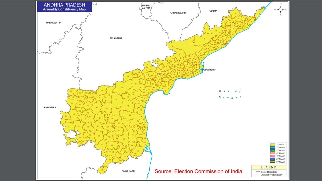
#/media/Datei:Sooner-Logo.jpg)
_no_heading.svg)
_-_DE.png)