framless
Talleyrand6
This user contributes to Wikimedia Commons in the area of Politics
Talleyrand6 has been on Wikimedia Commons for3 years and 14 days
Hello, I'm a novice contributor to English Wikipedia. I'm interested in politics and other related matters. I make maps, I guess. Best known for my maps of the 2022 French and Italian Elections. I am currently working on creating new maps for early American Congressional & Presidential elections. I'm a resident of the great Commonwealth of Virginia . I'm constantly improving my work, which means I become increasingly dissatisfied with my older maps, leading me to "update" them, even If they're perfectly good. My focus is mostly on political maps. I mainly use Inkscape as it is what I am most proficient in, but I also dabble in professional GIS programs such as QGIS. I have very eclectic interests and as such my maps cover a wide range of places. Possibly respobsible for the great 2020 Pennsylvania Presidential Election controversy.
HEADS UP: Open the files in a new tab to look at them properly. Wiki Commons does not render vectors/vector fonts well. Also best to just open up the maps in a new tab either way to get a better view. Recognition [ edit ]
The Graphic Designer's Barnstar
Thank you for diligently creating and updating maps for the French election! ev (talk)
The Graphic Designer's Barnstar
Thank you for the superb and high quality maps you've created. From the US, to Italy , to Australia—your map making skills are highly appreciated and make this site much better. Here's to more fantastic work 🍻! Aficionado538 (talk ) 23:27, 17 January 2023 (UTC)
Aficionado538 (talk ) 23:27, 16 January 2023 (UTC)
Congressional Maps [ edit ]
Results of the 1788 United States House of Representatives elections.
Results of the 1790-1792 United States House of Representatives elections.
Results of the 1792-1793 United States House of Representatives elections.
Results of the 1794-1795 United States House of Representatives elections.
Results of the 1796-1797 United States House of Representatives elections.
Results of the 1798-1799 United States House of Representatives elections.
Results of the 1800-1801 United States House of Representatives elections.
Results of the 1802-1803 United States House of Representatives elections.
Results of the 1804-1805 United States House of Representatives elections.
Results of the 1806-1807 United States House of Representatives elections.
Results of the 1808-1809 United States House of Representatives elections.
Results of the 1810-1811 United States House of Representatives elections.
Results of the 1920 United States House of Representatives elections.
1964 United States House Elections.
Northern Ireland [ edit ] Including individual maps of all constituencies from 1929-1969 as seen here
Clipped Irish Counties Map with Lakes
Clipped Irish Counties with Lakes (Less Detail)
Northern Ireland Parliamentary Constituencies 1929-1969
1929 Northern Ireland General Election
1933 Northern Ireland Assembly Election Results Map
1938 Northern Ireland Assembly Election Results Map
1945 Northern Ireland Assembly Election Results Map
1949 Northern Ireland Assembly Election Results Map
2022 Northern Ireland Election Map
2022 December Northern Ireland Assembly Election Results Map
Local Councils [ edit ] French National Elections [ edit ]
2022 French Presidential Election First Round Map
2022 French Presidential Election Second Round Map
Vote share map of the 2022 French Presidential Election First Round in Petite Couronne by Commune
2010 French Legislative Circonscriptions Map
2012 French Legislative Election Results Map First Round
2012 French Legislative Election Results Map Second Round
2017 French Legislative Election Results Map First Round
2017 French Legislative Election Results Map Second Round
2022 French Legislative Election Results Map First Round
2022 French Legislative Election Results Map Second Round
French Legislative Constituencies [ edit ] Source for Circonscription shapefiles comes from data.gouv.fr however, the link doesn't work, but the one from panneaux-election.fr does. Source for Commune shapefiles comes from data.gouv.fr as well Municipal subdivisions such as the Quartiers de Marseille & Cantons de la commune de Lyon come directly from their respective open data pages, results may differ in quality, sorry.
Legislative Constituencies of Brittany
Legislative Constituencies of Provence-Alpes-Côte d'Azur
Legislative Constituencies of Hauts-de-France
Legislative Constituencies of the Nord Department
Legislative Constituencies of the Pas deCalais Department
Legislative Constituencies of the Bouches-du-Rhône Department
Legislative Constituencies of the Essonne Department
Legislative Constituencies of the Rhône Department
Legislative Constituencies of the Seine-Saint-Denis Department
Legislative Constituencies of Paris
Legislative Constituencies of Martinique
Legislative Constituencies of La Réunion
Legislative Constituencies of New Caledonia
United Kingdom General Elections [ edit ]
January 1910 United Kingdom General Election
December 1910 United Kingdom General Election
1983 United Kingdom General Election
1992 United Kingdom General Election
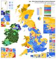
2023 UK Constituencies Blank Map
Italian General Elections [ edit ]
2022 Italian General Election in the House of Deputies FPTP seats by Coalition
2022 Italian General Election in the House of Deputies PR seats by Coalition.
2022 Italian General Election in the Senate FPTP seats by Coalition
2022 Italian General Election in the Senate PR seats by Party
2023 Lombard Regional Election showing party results.
2023 Lazio Regional Election map
2023 Lazian Regional Election Party Comuni Results map
Canadian Elections [ edit ]
1867 Canadian General Election
1980 Canadian General Election
1984 Canadian General Election
2004 Canadian General Election
2008 Canadian General Election
2011 Canadian General Election
2015 Canadian General Election
2019 Canadian General Election
2022 Québec General Election Map
2023 Alberta General Election Map
2023 Manitoba General Election (Talleyrand6)
2024 British Columbia Provincial General Election
2023 PEI General Election Map
Map of the 2019 P.E.I. General Election by Electoral Polls
Map of the 2023 P.E.I. General Election by Electoral Polls
2021 Nova Scotia General Election Riding Flips
European Elections [ edit ]
2014 European Parliamentary Election Map in the united kingdom by local authorities
2019 European Parliamentary Election Map in the united kingdom by local authorities
2019 European Union Election in Italy by Province
2014 European Parliamentary Election in France by Department
2019 European Parliamentary Election in France by department
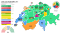
Swiss Elections [ edit ]
2015 Swiss Assembly Election Map
2015 Swiss Federal election Council of States
2019 Swiss Assembly Election Map
2019 Swiss Federal election Council of States
Other Maps [ edit ]
Map of the 2022 Swedish election shaded by party strength.
Map of the 2022 Swedish election shaded by coalition strength.
2019 Australian Senate Results
2022 Jersey General Election Map
2022 Andalusian Regional Election.
2018 Luxembourg Election Commune Map
2022 Estonian Election Municipalities
2023 Greek Legislative Election Map
2023 Greek Legislative Snap Election
2021 Dutch General Election
2023 Dutch General Election
English Local Councils [ edit ] English Counties [ edit ]
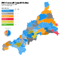
2021 Cornish Council Election
2021 Kent County Election
2023 Herefordshire County Council Election Map
1922 London County Council
1934 London County Council Election map
District Councils [ edit ]
2023 Cotswold District Council Election
2023 Mid Suffolk District Election Map
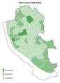
2023 Lancaster City Wards
2023 Lancaster City Council Election
Borough Councils [ edit ]
Liverpool City Council Wards Map 2022
2023 Liverpool City Council Election Map
Bristol Municipal Election 2016
Bristol Municipal Election 2021
2019 Brighton & Hove City Council Election map
2023 Brighton City Council Election Map
2023 Sunderland City Council Election
2010 Westminster Borough Council Election
2014 Westminster Borough Council Election
2018 Westminster Borough Council Election
2022 Westminster Borough Council Election
2022 Wirral Borough Council Election Map
2023 Wirral Borough Council Election Map
2023 Hull City Council Election Map
Scottish Elections [ edit ] American Maps [ edit ]
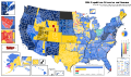
2016 GOP Presidential Primary Primary Subdivision Map
US Presidential Infobox Map Template (Proposal)
1860 United States Presidential Election mapped by Counties
1864 United States Presidential Election mapped by Counties
1855 Virginia Gubernatorial Election
Virginia Senate District Map (2023)
This map shows the 2016 presidential election precinct level results in Virginia.
2023 Virginia State Senate
2023 Virginia 7th State Senate District Special Election colored by precinct
Virginia's 7th State Senate district
2022 Congressional Election in Wisconsin's 1st District Precinct map
2022 Congressional Election in Wisconsin's 4th District precinct map
2022 United States House of Representatives elections in Oregon calculated by county.
2022 Kansas Value Them Both Amendment results map by county
2016 Norfolk Mayoral Election by Precinct
2018 Virginia Beach Mayoral Election
US District County Maps [ edit ]
2022 Congressional Election in Illinois' 12th District
2022 Congressional Election in Illinois' 13th District
2022 Congressional Election in Illinois' 15th District
2022 Congressional Election in Illinois' 16th District
2022 Congressional Election in Illinois' 17th District
Oregon 4th Congressional District 2022
Oregon 2nd Congressional District 2022 map
Oregon 1st Congressional District 2022 map
Oregon 6th Congressional District 2022 map
Oregon 3rd Congressional District 2022
2022 Congressional Election in Virginia's 1st District
2022 Congressional Election in Virginia's 2nd District
2022 Congressional Election in Virginia's 3rd District
2022 Congressional Election in Virginia's 4th District
2023 Special Congressional Election in Virginia's 4th District
2022 Congressional Election in Virginia's 6th District
2022 Congressional Election in Virginia's 9th District
2022 Congressional Election in Wisconsin's 3rd District
2022 Congressional Election in Minnesota's 1st District
2022 Congressional Election in Minnesota's 6th District
2022 Congressional Election in Minnesota's 7th District
2022 Congressional Election in Minnesota's 8th District
Featured [ edit ] 1984 Canadian General Election 


 Results of the 1788 United States House of Representatives elections.
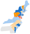 Results of the 1790-1792 United States House of Representatives elections.
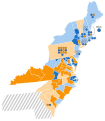 Results of the 1792-1793 United States House of Representatives elections.
 Results of the 1794-1795 United States House of Representatives elections.
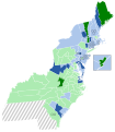 Results of the 1796-1797 United States House of Representatives elections.
 Results of the 1798-1799 United States House of Representatives elections.
 Results of the 1800-1801 United States House of Representatives elections.
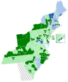 Results of the 1802-1803 United States House of Representatives elections.
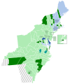 Results of the 1804-1805 United States House of Representatives elections.
 Results of the 1806-1807 United States House of Representatives elections.
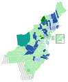 Results of the 1808-1809 United States House of Representatives elections.
 Results of the 1810-1811 United States House of Representatives elections.
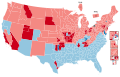 Results of the 1920 United States House of Representatives elections.
 1964 United States House Elections.


 Clipped Irish Counties Map with Lakes
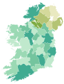 Clipped Irish Counties with Lakes (Less Detail)
 Northern Ireland Parliamentary Constituencies 1929-1969
 1929 Northern Ireland General Election
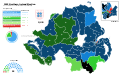 1933 Northern Ireland Assembly Election Results Map
 1938 Northern Ireland Assembly Election Results Map
 1945 Northern Ireland Assembly Election Results Map
 1949 Northern Ireland Assembly Election Results Map
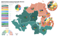 2022 Northern Ireland Election Map
 2022 December Northern Ireland Assembly Election Results Map
.svg)


 2022 French Presidential Election First Round Map
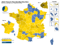 2022 French Presidential Election Second Round Map
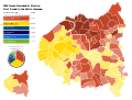 Vote share map of the 2022 French Presidential Election First Round in Petite Couronne by Commune
 2010 French Legislative Circonscriptions Map
 2012 French Legislative Election Results Map First Round
 2012 French Legislative Election Results Map Second Round
 2017 French Legislative Election Results Map First Round
 2017 French Legislative Election Results Map Second Round
 2022 French Legislative Election Results Map First Round
 2022 French Legislative Election Results Map Second Round


 Legislative Constituencies of Brittany
 Legislative Constituencies of Provence-Alpes-Côte d'Azur
 Legislative Constituencies of Hauts-de-France
 Legislative Constituencies of the Nord Department
 Legislative Constituencies of the Pas deCalais Department
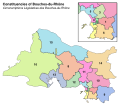 Legislative Constituencies of the Bouches-du-Rhône Department
 Legislative Constituencies of the Essonne Department
 Legislative Constituencies of the Rhône Department
 Legislative Constituencies of the Seine-Saint-Denis Department
 Legislative Constituencies of Paris
 Legislative Constituencies of Martinique
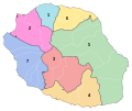 Legislative Constituencies of La Réunion
 Legislative Constituencies of New Caledonia


 January 1910 United Kingdom General Election
 December 1910 United Kingdom General Election
 1983 United Kingdom General Election
 1992 United Kingdom General Election
 2023 UK Constituencies Blank Map


 2022 Italian General Election in the House of Deputies FPTP seats by Coalition
 2022 Italian General Election in the House of Deputies PR seats by Coalition.
 2022 Italian General Election in the Senate FPTP seats by Coalition
 2022 Italian General Election in the Senate PR seats by Party
 2023 Lombard Regional Election showing party results.
 2023 Lazio Regional Election map
 2023 Lazian Regional Election Party Comuni Results map


 1867 Canadian General Election
 1980 Canadian General Election
 1984 Canadian General Election
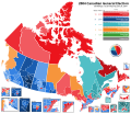 2004 Canadian General Election
 2008 Canadian General Election
 2011 Canadian General Election
 2015 Canadian General Election
 2019 Canadian General Election
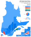 2022 Québec General Election Map
 2023 Alberta General Election Map
 2023 Manitoba General Election (Talleyrand6)
 2024 British Columbia Provincial General Election
 2023 PEI General Election Map
 Map of the 2019 P.E.I. General Election by Electoral Polls
 Map of the 2023 P.E.I. General Election by Electoral Polls
 2021 Nova Scotia General Election Riding Flips


.svg)


 2014 European Parliamentary Election Map in the united kingdom by local authorities
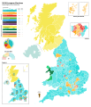 2019 European Parliamentary Election Map in the united kingdom by local authorities
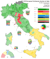 2019 European Union Election in Italy by Province
 2014 European Parliamentary Election in France by Department
 2019 European Parliamentary Election in France by department


 2015 Swiss Assembly Election Map
 2015 Swiss Federal election Council of States
 2019 Swiss Assembly Election Map
 2019 Swiss Federal election Council of States


 Map of the 2022 Swedish election shaded by party strength.
 Map of the 2022 Swedish election shaded by coalition strength.
 2019 Australian Senate Results
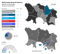 2022 Jersey General Election Map
 2022 Andalusian Regional Election.
 2018 Luxembourg Election Commune Map
 2022 Estonian Election Municipalities
 2023 Greek Legislative Election Map
 2023 Greek Legislative Snap Election
 2021 Dutch General Election
 2023 Dutch General Election


 2021 Cornish Council Election
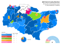 2021 Kent County Election
 2023 Herefordshire County Council Election Map
 1922 London County Council
 1934 London County Council Election map


 2023 Cotswold District Council Election
 2023 Mid Suffolk District Election Map
 2023 Lancaster City Wards
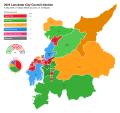 2023 Lancaster City Council Election


 Liverpool City Council Wards Map 2022
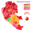 2023 Liverpool City Council Election Map
 Bristol Municipal Election 2016
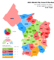 Bristol Municipal Election 2021
 2019 Brighton & Hove City Council Election map
 2023 Brighton City Council Election Map
 2023 Sunderland City Council Election
 2010 Westminster Borough Council Election
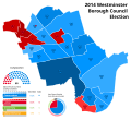 2014 Westminster Borough Council Election
 2018 Westminster Borough Council Election
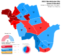 2022 Westminster Borough Council Election
 2022 Wirral Borough Council Election Map
 2023 Wirral Borough Council Election Map
 2023 Hull City Council Election Map


 Next Scottish Parliament election Map
 2016 GOP Presidential Primary Primary Subdivision Map
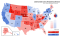 US Presidential Infobox Map Template (Proposal)
 1860 United States Presidential Election mapped by Counties
 1864 United States Presidential Election mapped by Counties
 1855 Virginia Gubernatorial Election
 Virginia Senate District Map (2023)
 This map shows the 2016 presidential election precinct level results in Virginia.
 2023 Virginia State Senate
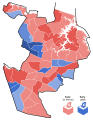 2023 Virginia 7th State Senate District Special Election colored by precinct
 Virginia's 7th State Senate district
 2022 Congressional Election in Wisconsin's 1st District Precinct map
 2022 Congressional Election in Wisconsin's 4th District precinct map
 2022 United States House of Representatives elections in Oregon calculated by county.
 2022 Kansas Value Them Both Amendment results map by county
 2016 Norfolk Mayoral Election by Precinct
 2018 Virginia Beach Mayoral Election
.svg)


.svg)
.svg)


.svg)
.svg)


 2022 Congressional Election in Illinois' 12th District
 2022 Congressional Election in Illinois' 13th District
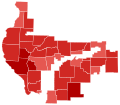 2022 Congressional Election in Illinois' 15th District
 2022 Congressional Election in Illinois' 16th District
 2022 Congressional Election in Illinois' 17th District
 Oregon 4th Congressional District 2022
 Oregon 2nd Congressional District 2022 map
 Oregon 1st Congressional District 2022 map
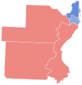 Oregon 6th Congressional District 2022 map
 Oregon 3rd Congressional District 2022
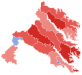 2022 Congressional Election in Virginia's 1st District
 2022 Congressional Election in Virginia's 2nd District
 2022 Congressional Election in Virginia's 3rd District
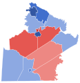 2022 Congressional Election in Virginia's 4th District
 2023 Special Congressional Election in Virginia's 4th District
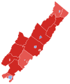 2022 Congressional Election in Virginia's 6th District
 2022 Congressional Election in Virginia's 9th District
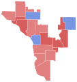 2022 Congressional Election in Wisconsin's 3rd District
 2022 Congressional Election in Minnesota's 1st District
 2022 Congressional Election in Minnesota's 6th District
 2022 Congressional Election in Minnesota's 7th District
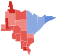 2022 Congressional Election in Minnesota's 8th District


