<nowiki>Rothenfels; Rothenfels; Rothenfels; Rothenfels; Rothenfels; Rothenfels; Rothenfels; 羅滕費爾斯; Rothenfels; Rothenfels; Ротенфельс; 羅滕費爾斯; Rothenfels; Rothenfels; Rothenfels; Ротенфельс; Rothenfels; Rothenfels; Rothenfels; Rothenfels; Rothenfels; Rothenfels; Rothenfels; روتەنفەلس; Rotenfelʹs; Rothenfels; Roudäfals; Rothenfels; Rothenfels; Rothenfels; Ротенфельс; Rothenfels; Rothenfels; Rothenfels; Rothenfels; روتنفلز; Rothenfels; Rothenfels; 罗滕费尔斯; Ռոթենֆելս; Rothenfels; Rothenfels; Ротенфельс; Rothenfels; Rothenfels; Rothenfels; Ротенфельс; Rothenfels; Rothenfels; Rothenfels; Rothenfels; رتنفلز; 罗滕费尔斯; Rothenfels; Rothenfels; ローテンフェルス; Rothenfels; Rothenfels; Rothenfels; Rothenfels; Rothenfels; Ротенфельс; Rothenfels; Rothenfels; Rothenfels; Rothenfels; Rothenfels; Rothenfels; Rothenfels; Rothenfels; Rothenfels; Ротенфелс; Rothenfels; Rothenfels; Rothenfels; Rothenfels; Rothenfels; Rothenfels; Rothenfels; Rothenfels; Rothenfels; Rotenfels; Rothenfels; Rothenfels; Rothenfels; Rothenfels; Rothenfels; Rothenfels; Rothenfels; Rothenfels; Rothenfels; Rothenfels; Rothenfels; Rothenfels; Ротенфельс; Rothenfels; Rothenfels; Rothenfels; Rothenfels; روتنفلز; Rothenfels; Ротенфелс; comune tedesco; commune allemande; Alemaniako hiria; město w Bayerskej; komunë në Gjermani; Gmee (Stôdd) im Landgreis Mee-Spessärd in Döüdschlônd; ドイツ、バイエルン州マイン=シュペッサルト郡の市; Gemeinde im Landkreis Main-Spessart in Deutschland; kota di Jerman; miasto w Niemczech; місто в Німеччині, федеральна земля Баварія; gemeente in Beieren; obec v zemském okresu Main-Spessart v Německu; lungsod; település Németországban; chemun de la Germania; town in Bavaria, Germany; komunumo en Bavario, Germanio; kumun alaman; Bajarokekî Almanyayê; Ротҳенфелс; Ротенфелс; Rotenfels; Rothenfels; Stadt Rothenfels; Stôdd Roudäfals</nowiki>
part of Landkreis Main-Spessart << Unterfranken << Bayern << Germany
Lage
Stadtansicht von Nordosten
Hauptstraße
Rathaus
Kirche Mariä Himmelfahrt
Rothenfels, Kirche, Innenansicht
Burg Rothenfels
Main category:
Burg Rothenfels
This is a gallery page Rothenfels , see Category:Rothenfels


 Lage
Lage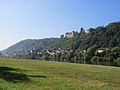 Stadtansicht von Nordosten
 Hauptstraße
 Rathaus
 Kirche Mariä Himmelfahrt
 Rothenfels, Kirche, Innenansicht
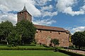 Burg RothenfelsMain category: Burg Rothenfels


