Landkreis Landsberg am Lech
Jump to navigation
Jump to search
district of Bavaria, Germany    | |||||
| Upload media | |||||
| Instance of |
| ||||
|---|---|---|---|---|---|
| Location | Upper Bavaria, Bavaria, Germany | ||||
| Capital | |||||
| Head of government |
| ||||
| Inception |
| ||||
| Population |
| ||||
| Area |
| ||||
| Elevation above sea level |
| ||||
| official website | |||||
 | |||||
-
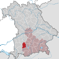 Lagekarte
History[edit]
Main category: History of Landkreis Landsberg am Lech
-
 Schlacht auf dem Lechfeld am 10. August 955

Buildings and structures[edit]
-
 Hauptplatz von Landsberg am Lech
 -
 Schloss Pöring
.jpg)

Categories[edit]
| To display all subcategories click on the "▶":
no subcategories Endmoräne (Geltendorf) (3 F) Hurlacher Heide (3 F) Geography of Kaufering (6 F) Moränensee (Unterfinning) (5 F) Staatsforst Bayerdießen (5 F) Toteisloch (Memming) (3 F) Toteisloch (Ramsach) (3 F) Geography of Unterdießen (6 F) Views of Apfeldorf (4 F) no subcategories |