Landkreis Oberallgäu
Jump to navigation
Jump to search
district in Bavaria, Germany    | |||||
| Upload media | |||||
| Instance of |
| ||||
|---|---|---|---|---|---|
| Location | Swabia, Bavaria, Germany | ||||
| Capital | |||||
| Head of government |
| ||||
| Inception |
| ||||
| Population |
| ||||
| Area |
| ||||
| Elevation above sea level |
| ||||
| official website | |||||
 | |||||
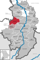
located in the administrative territorial entity Bayer. Schwaben
-
 Lage in Deutschland
 -
 Lage im Regierungsbezirk Schwaben / in Bayern
 -

-


Kommunen[edit]
-
 Kartierung aller Kommunen

Städte[edit]
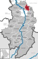
Immenstadt im Allgäu[edit]
Main gallery: Immenstadt im Allgäu.
Main category: Immenstadt im Allgäu
-
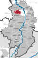
 Lage
Lage -
 Wappen
 -
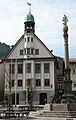 Rathaus
 -
 Mariensäule
 -
 kath. Stadtpfarrkirche St. Nikolaus
 -
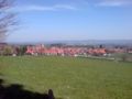
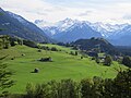
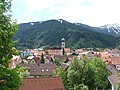 Blick über Immenstadt Richtung Mittagberg
 -
 Kreuzigungsszene
 -
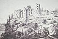 Ruine Rothenfels 1816
 -
 Immenstadt um 1523 nach Bernhard Strigel
 -
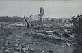
 Nach der Hochwasserkatastrophe 1873


Sonthofen[edit]
Main gallery: Sonthofen.
Main category: Sonthofen
-
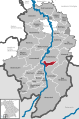
 Lage
Lage -
 Wappen
 -
 Sonthofen von Nordwesten
 -
 Sonthofen von Südwesten
 -
 Marktstraße in Sonthofen
 -
 Altstädten
 -
 Stadtansicht vom Mittag
 -
 alte Schule
 -
 Leprarätsche
 -
 Altstädten mit Hörnergruppe


Märkte[edit]
Altusried[edit]
Main gallery: Altusried.
Main category: Altusried
-
 Lage
Lage -
 Wappen
 -
 Ortsansicht
 -
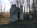 Ruine Kalden
 -
 Kimratshofen
 -
 Krugzell
 -
 Frauenzell
 -
 Westfassade der Kirche von Frauenzell
 -
 kath. Kirche St. Mauritius in Muthmannshofen
 -
 Von Altkalden blieb nur noch ein schmaler Grat übrig.
 -
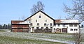
 ehem. Bauernhof in Walkenberg
 -
 Hängebrücke Fischers-Pfosen
 -
 Freilichtbühne Altusried


.JPG)

Bad Hindelang[edit]
Main gallery: Bad Hindelang.
Main category: Bad Hindelang
-
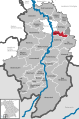
 Lage
Lage -
 Wappen
 -
 Bad Hindelang mit Kath. Kirche St. Johannes d. Täufer
 -
 Blick über Bad Hindelang, im Vordergrund der Ortsteil Bad Oberdorf mit der Kirche Unserer Lieben Frau im Ostrachtal und St. Jodokus
 -
 katholische Kirche St. Johannes d. Täufer
 -
 Gefallenen-Gedenkkapelle
 -
 Kapelle in Bruck
 -
 Hammerschmiede in Bad Hindelang
 -
 Gasthof Adler-Post
 -
 Hotel Sonne
 -
 Der so genannte Salzbrunnen erinnert an den Salzhandel über den Oberjochpass
 -
 Bad Hindelang im Ostrachtal
 -
 Bad Oberdorf
 -
 Jochpass (1178 m)
 -
 kath. Kirche Hl. Geist in Oberjoch (1150 m)
 -
 Ostrachtal bei Bruck
 -
 Viehscheid im Hintersteiner Tal
 -
 Unterjoch


_Bad_Hindelang_sunny_summer_day_part.jpg)


-
 Blick in das Ostrachtal nach Norden

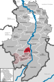
Dietmannsried[edit]
Main category: Dietmannsried
-
 Lage
Lage -
 Wappen
 -
 Dietmannsried, Blick von Westen
 -
 Dietmannsried von Osten
 -
 Innenraum der Kirche im neugotischen Stil
 -
 Der Inselweiher, im Mittelalter eine Motte auf einer künstlichen Insel
 -
 A 7 – „Allgäuer Tor“
 -
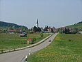
 Dietmannsried und Reicholzried
 -
 Dietmannsrieder Flur
 -
 Paragliding bei Hinterhalde
 -
 Käsers
 -
 Öschle
 -
 Probstried
 -
 Reicholzried
 -
 Sachsenrieder Weiher
 -
 Schrattenbach
 -
 Überbach
 -
 Todtenberg


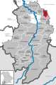
Oberstaufen[edit]
Main gallery: Oberstaufen.
Main category: Oberstaufen
-
 Lage
Lage -
 Wappen
 -
 Oberstaufen von Westen
 -
 St. Peter und Paul
 -
 Blick auf den Altar der Pfarrkirche St. Peter und Paul
 -
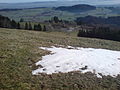
 Ureibe bei Steibis
 -
 Evangelisch-Lutherische Heilig-Geist-Kirche Oberstaufen
 -
 Schriftzug an der Alpenstraße
 -
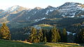 Nagelfluhkette mit Hochgrat und Eineguntkopf
 -
 Blick vom Rindalphorn Richtung Oberstaufen
 -
 Ortskern vom Seelekopf


Oberstdorf[edit]
Main gallery: Oberstdorf.
Main category: Oberstdorf
-
 Lage
Lage -
 Wappen
 -
 Blick auf Oberstdorf (Sommer)
 -
 Blick auf Oberstdorf (Winter)
 -
 Das Nebelhorn, der Hausberg von Oberstdorf
 -
 Blick vom Gaißalphorn auf Oberstdorf
 -
 Oberstdorfer Skisprungschanzen am Schattenberg (Audi Arena)
 -
 Heini-Klopfer-Skiflugschanze
 -
 Seelenkapelle
 -
 Gedenkstätte für Kinder im Kurpark
 -
 Wilder Mann-Statue in Oberstdorf
 -
 Allgäuer Volksbank und Fremdenverkehrsamt
 -
 Busbahnhof


Sulzberg[edit]
Main category: Sulzberg (Oberallgäu)
-
 Lage
Lage -
 Wappen
 -
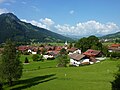
 Sulzberg von Westen
 -
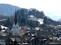 Der Ort Sulzberg und die Ruine Sulzberg
 -
 Ruine Sulzberg
 -
 Feuerwehrmuseum
 -
 Mühle in Aleuthe
 -
 Ried Ottacker
 -
 Winterlandschaft bei Sulzberg


.jpg)
Weitnau[edit]
Main category: Weitnau
-
 Lage
Lage -
 Wappen
 -
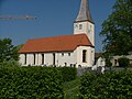
 Rechtis mit Kirche St. Ulrich
 -
 Gasthaus Adler


Wertach[edit]
Main category: Wertach
-
 Lage
Lage -
 Wappen
 -
 Ortsansicht
 -
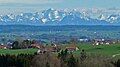
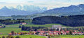
 Ellegger Höhe (1100 m ü. NHN) bei Wertach mit Allgäuer Alpen
 -
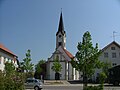
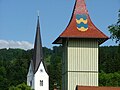
 Wertach, Kirche St. Ulrich
 -
 Sorgschrofen, Iseler und Wertacher Hörnle
 -
 Ortsteil Bichel, südlich von Wertach
 -
 Wertach von Osten
 -
 Ortsansicht
 -
 Wertach nach dem Brand 1893


Wiggensbach[edit]
Main category: Wiggensbach
-
 Lage
Lage -
 Wiggensbacher Gemeindegebiet
 -
Wappen
-
 Wiggensbach von Norden
 -
 Wiggensbach
 -
 Gemeindeteil Westenried


weitere Gemeinden[edit]
-
 BalderschwangMain category: Balderschwang
 -

-

-
 BolsterlangMain category: Bolsterlang
 -
 Burgberg im AllgäuMain category: Burgberg im Allgäu
 -
-
 Fischen im AllgäuMain category: Fischen im Allgäu
 -
 HaldenwangMain category: Haldenwang
 -
 Lauben (Oberallgäu)Main category: Lauben (Oberallgäu)
 -
 Missen-WilhamsMain category: Missen-Wilhams
 -
 ObermaiselsteinMain category: Obermaiselstein
 -
 OfterschwangMain category: Ofterschwang
 -
 Oy-MittelbergMain category: Oy-Mittelberg
 -
 RettenbergMain category: Rettenberg
 -
 WaltenhofenMain category: Waltenhofen
 -
 WildpoldsriedMain category: Wildpoldsried


Verschiedenes[edit]
-
 Malerwinkel bei Sonthofen
 -

-
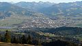
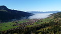
 Blick auf Immenstadt vom Steineberg
 -
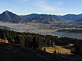
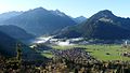
 Blick auf Immenstadt mit Großem und Kleinem Alpsee und Grünten
 -
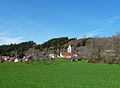
 Ermengerst im Tal vom Blender aus gesehen
 -
 Ermengerst vom Parkplatz Blender aus gesehen


Urban districts (cities): Amberg · Ansbach · Aschaffenburg · Augsburg · Bamberg · Bayreuth · Coburg · Erlangen · Fürth · Hof · Ingolstadt · Kaufbeuren · Kempten · Landshut · Memmingen · Munich · Nuremberg · Passau · Regensburg · Rosenheim · Schwabach · Schweinfurt · Straubing · Weiden in der Oberpfalz · Würzburg
