File:A new and correct map of the world, laid down according to the newest discoveries, and from the most exact observations. NYPL1630429.tiff
Jump to navigation
Jump to search

Size of this JPG preview of this TIF file: 800 × 482 pixels. Other resolutions: 320 × 193 pixels | 640 × 386 pixels | 1,024 × 617 pixels | 1,280 × 771 pixels | 2,560 × 1,543 pixels | 6,528 × 3,934 pixels.
Original file (6,528 × 3,934 pixels, file size: 73.5 MB, MIME type: image/tiff)
Captions
Captions
Add a one-line explanation of what this file represents
Summary[edit]
| Description | A new and correct map of the world, laid down according to the newest discoveries, and from the most exact observations. | |||||||||||||||||||||||
| Notes | To His most sacred Majesty George II, ... King of Great Britain, France & Ireland ... this map is humbly dedicated. | |||||||||||||||||||||||
| Standard reference | Variant of Phillips 554 | |||||||||||||||||||||||
| Item/Page/Plate | 1 | |||||||||||||||||||||||
| Physical description | 1 map : hand col. ; 64 x 101 cm., folded to 64 x 28 cm. | |||||||||||||||||||||||
| Catalog Call Number | Map Div. 97-6053[LHS 329; atlas cases] | |||||||||||||||||||||||
| Date | circa 1736 | |||||||||||||||||||||||
| Source |
http://digitalgallery.nypl.org/nypldigital/dgkeysearchdetail.cfm?imageID=1630429
|
|||||||||||||||||||||||
| Author | Moll, Herman, d. 1732 -- CartographerBowles, Thomas, 1694-1773 -- Bookseller | |||||||||||||||||||||||
| Permission (Reusing this file) |
From The Lionel Pincus & Princess Firyal Map Division. Released on a CC0 license.[1] | |||||||||||||||||||||||
| Source Description | 1 atlas (65 leaves (most folded)) : 31 maps (most hand col.) ; 65 cm. | |||||||||||||||||||||||
| Digital ID | 1630429 | |||||||||||||||||||||||
| Location | Stephen A. Schwarzman Building / The Lionel Pincus and Princess Firyal Map Division | |||||||||||||||||||||||
| NYPL digital item published | 5-12-2008; updated 1-9-2012 | |||||||||||||||||||||||

Licensing[edit]
| This file is made available under the Creative Commons CC0 1.0 Universal Public Domain Dedication. | |
| The person who associated a work with this deed has dedicated the work to the public domain by waiving all of their rights to the work worldwide under copyright law, including all related and neighboring rights, to the extent allowed by law. You can copy, modify, distribute and perform the work, even for commercial purposes, all without asking permission.
|
The making of this file was supported by Wikimedia UK.
To see other files made with the support of Wikimedia UK, please see the category Supported by Wikimedia UK.
|
File history
Click on a date/time to view the file as it appeared at that time.
| Date/Time | Thumbnail | Dimensions | User | Comment | |
|---|---|---|---|---|---|
| current | 06:59, 4 May 2014 |  | 6,528 × 3,934 (73.5 MB) | Fæ (talk | contribs) | crop (uploaded using chunked upload script) |
| 13:12, 6 April 2014 | 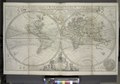 | 6,930 × 4,826 (95.69 MB) | Fæ (talk | contribs) | =={{int:filedesc}}== {{NYPL_map |source_description = 1 atlas (65 leaves (most folded)) : 31 maps (most hand col.) ; 65 cm. |standard_reference = Variant of Phillips 554 |record_id = 1767541 |catalog_call_number = Map Div. 97-6053[LHS 329; atlas cases]... |
You cannot overwrite this file.
File usage on Commons
The following 2 pages use this file:
File usage on other wikis
The following other wikis use this file:
- Usage on fr.wikipedia.org