Category:1700s maps of the Atlantic Ocean
Jump to navigation
Jump to search
Media in category "1700s maps of the Atlantic Ocean"
The following 15 files are in this category, out of 15 total.
-
 A chart of the sea coast from ENGLAND to the STREIGHTS NYPL1640593.tiff 7,230 × 5,428; 112.28 MB
-
 A large chart of the BAY OF BISCAY NYPL1640602.tiff 5,428 × 7,230; 112.28 MB
-
 Charles Price, A new generall chart of the coast of Guinea and Brasil (FL37810804 3151441).jpg 16,155 × 12,959; 275.6 MB
-
 A new draught of the coast of GUINEA and BRASILE NYPL1640612.tiff 7,230 × 5,428; 112.28 MB
-
-
 A generall chart from ENGLAND to cape Bona Espranca with the coast of BRASILE NYPL1640675.tiff 5,428 × 7,230; 112.28 MB
-
 A new and correct chart from England to Guinea .... NYPL481137.tiff 7,230 × 5,428; 112.28 MB
-

-
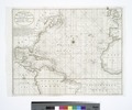
 The Western Ocean (NYPL b15280125-434477).jpg 5,459 × 4,800; 5.45 MB
-
 The Western Ocean (NYPL b15280125-434477).tiff 5,459 × 4,800; 74.97 MB
-

-

-

-

-

.jpg)
.jpg)
.jpg)
.jpg)
.jpg)
