Category:Sanborn maps of the Bronx published in 1891, V. 10
Jump to navigation
Jump to search
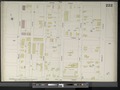
Maps from: Insurance Maps of the City of New York Surveyed and Published by Sanborn–Perris Map Co., Limited. Volume 10. (New York: 1891), comprising 27 maps (double-page plates) plus double-page title page with volume key (scanned in two images), and street index.
Online at The New York Public Library Digital Collections website, Atlas 42.60. Vol. 10, 1891.
Media in category "Sanborn maps of the Bronx published in 1891, V. 10"
The following 31 files are in this category, out of 31 total.
-
-

-
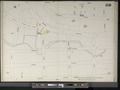
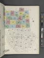 Key NYPL2001829.tiff 6,732 × 8,984, 2 pages; 173.1 MB
-
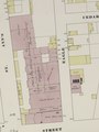
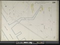
 Index NYPL2001827.tiff 6,701 × 8,942, 2 pages; 171.49 MB
-
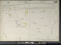
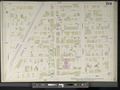
 Bronx, V. 10, Double Page Plate No. 212 (Map bounded by Trinity Ave., E. 163rd St., Prospect Ave., E. 156th St.) NYPL2001830.tiff 8,861 × 6,640, 2 pages; 168.4 MB
-
-
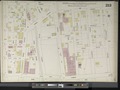
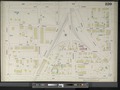
 Bronx, V. 10, Double Page Plate No. 214 (Map bounded by E. 161st St., Elton Ave., E. 156th St., Morris Ave.) NYPL2001832.tiff 8,922 × 6,686, 2 pages; 170.73 MB
-
 Bronx, V. 10, Double Page Plate No. 215 (Map bounded by E. 161st St., Morris Ave., River Ave.) NYPL2001833.tiff 8,902 × 6,670, 2 pages; 169.94 MB
-
 Bronx, V. 10, Double Page Plate No. 216 (Map bounded by E. 161st St., River Ave., Harlem River, Jerome Ave.) NYPL2001834.tiff 8,887 × 6,660, 2 pages; 169.4 MB
-
 Bronx, V. 10, Double Page Plate No. 217 (Map bounded by Harlem River, Bremer Ave., Jerome Ave.) NYPL2001835.tiff 8,887 × 6,660, 2 pages; 169.4 MB
-
 Bronx, V. 10, Double Page Plate No. 218 (Map bounded by Bremer Ave., Devoe St., Gerard Ave., E. 161st St.) NYPL2001836.tiff 8,887 × 6,660, 2 pages; 169.4 MB
-
 Bronx, V. 10, Double Page Plate No. 219 (Map bounded by E. 165th St., Morris Ave., E. 161st St., Gerard Ave.) NYPL2001837.tiff 8,887 × 6,660, 2 pages; 169.4 MB
-
 Bronx, V. 10, Double Page Plate No. 220 (Map bounded by E. 165th St., Washington Ave., E. 161st St., Morris Ave.) NYPL2001838.tiff 8,901 × 6,670, 2 pages; 169.92 MB
-
 Bronx, V. 10, Double Page Plate No. 221 (Map bounded by Washington Ave., George St., Trinity Ave., Clifton St.) NYPL2001839.tiff 8,931 × 6,692, 2 pages; 171.05 MB
-
 Bronx, V. 10, Double Page Plate No. 222 (Map bounded by George St., Prospect Ave., E. 163rd St., Trinity Ave.) NYPL2001840.tiff 8,931 × 6,692, 2 pages; 171.05 MB
-
 Bronx, V. 10, Double Page Plate No. 223 (Map bounded by Boston Rd., E. 169th St., Prospect Ave., George St.) NYPL2001841.tiff 8,952 × 6,708, 2 pages; 171.87 MB
-

-
 Bronx, V. 10, Double Page Plate No. 225 (Map bounded by Fleetwood Ave., E. 168th St., Washington Ave., E. 165th St.) NYPL2001843.tiff 8,976 × 6,726, 2 pages; 172.79 MB
-
 Bronx, V. 10, Double Page Plate No. 226 (Map bounded by E. 167th St., Fleetwood Ave., E. 165th St., Mott Ave.) NYPL2001844.tiff 8,976 × 6,726, 2 pages; 172.79 MB
-
 Bronx, V. 10, Double Page Plate No. 227 (Map bounded by E. 167th St., Mott Ave., E. 165th St., Bremer Ave.) NYPL2001845.tiff 8,976 × 6,726, 2 pages; 172.79 MB
-
 Bronx, V. 10, Double Page Plate No. 228 (Map bounded by Union St., Bremer Ave., Kemp Place., Harlem River) NYPL2001846.tiff 8,975 × 6,725, 2 pages; 172.74 MB
-
 Bronx, V. 10, Double Page Plate No. 229 (Map bounded by Orchard St., Union St., Harlem River) NYPL2001847.tiff 8,975 × 6,725, 2 pages; 172.74 MB
-
 Bronx, V. 10, Double Page Plate No. 230 (Map bounded by Clark Place, gerard Ave., Union St., Orchard St.) NYPL2001848.tiff 8,861 × 6,640, 2 pages; 168.4 MB
-
 Bronx, V. 10, Double Page Plate No. 231 (Map bounded by E. 169th St., Clay Ave., E. 167th St., Sherman Ave.) NYPL2001849.tiff 8,760 × 6,564, 2 pages; 164.57 MB
-
 Bronx, V. 10, Double Page Plate No. 232 (Map bounded by E. 170th St., Fulton St., E. 168th St., Clay Ave.) NYPL2001850.tiff 8,760 × 6,564, 2 pages; 164.57 MB
-
 Bronx, V. 10, Double Page Plate No. 233 (Map bounded by Horton St., Prospect Ave., E. 169th St., Fulton Ave.) NYPL2001851.tiff 8,951 × 6,707, 2 pages; 171.82 MB
-
 Bronx, V. 10, Double Page Plate No. 234 (Map bounded by Wendover Ave., Fulton Ave., E. 170th St., Elliot St.) NYPL2001852.tiff 8,951 × 6,707, 2 pages; 171.82 MB
-
 Bronx, V. 10, Double Page Plate No. 235 (Map bounded by Elliot St., Clay Ave., E. 169th St., Sherman Ave.) NYPL2001853.tiff 8,932 × 6,693, 2 pages; 171.1 MB
-
 Bronx, V. 10, Double Page Plate No. 236 (Map bounded by Jerome Ave., Elliot St., Sherman Ave., E. 167th St.) NYPL2001854.tiff 8,952 × 6,708, 2 pages; 171.87 MB
-
 Bronx, V. 10, Double Page Plate No. 237 (Map bounded by Elliot St., Jerome Ave., Clark Place, Orchard St., Ogden Ave.) NYPL2001855.tiff 8,853 × 6,634, 2 pages; 168.09 MB
-