Category:Old maps of the Balearic Islands
Jump to navigation
Jump to search
Autonomous communities of Spain: Andalusia · Aragon · Asturias · Balearic Islands · Canary Islands · Cantabria · Castile and León · Castile-La Mancha · Catalonia · Extremadura · Galicia · Community of Madrid · Region of Murcia · Navarre · Valencian Community · Autonomous cities: Ceuta · Melilla
Use the appropriate category for maps showing all or a large part of Balearic Islands. See subcategories for smaller areas:
| If the map shows | Category to use |
|---|---|
| Balearic Islands on a recently created map | Category:Maps of the Balearic Islands or its subcategories |
| Balearic Islands on a map created more than 70 years ago | Category:Old maps of the Balearic Islands or its subcategories |
| the history of Balearic Islands on a recently created map | Category:Maps of the history of the Balearic Islands or its subcategories |
| the history of Balearic Islands on a map created more than 70 years ago | Category:Old maps of the history of Balearic Islands or its subcategories |
Subcategories
This category has the following 4 subcategories, out of 4 total.
*
- Old maps of Formentera (8 F)
- Old maps of Ibiza (11 F)
Media in category "Old maps of the Balearic Islands"
The following 43 files are in this category, out of 43 total.
-
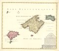
 "Insulae Balearides et Pytiusae." (22065793988).jpg 3,804 × 2,964; 2.06 MB
-

-

-

-
 Map - Special Collections University of Amsterdam - OTM- HB-KZL 32.22.53.tif 7,579 × 6,624; 143.63 MB
-
 Map - Special Collections University of Amsterdam - OTM- HB-KZL 32.24.29.tif 7,280 × 6,327; 131.78 MB
-
 Map - Special Collections University of Amsterdam - OTM- HB-KZL 32.24.31.tif 7,572 × 6,387; 138.37 MB
-

-
 Joseph Roux, Carte de la Mer Mediterranée (FL13732120 3373892).jpg 9,519 × 13,513; 178.32 MB
-
-
 William Faden. Composite Mediterranean. 1785.KA.jpg 802 × 393; 59 KB
-
 Map of part of the Mediterranean Sea from Malaga to the Island of Minorca (1803).png 2,368 × 2,368; 5.82 MB
-

-

-
 Carte des îles Baléares Iphigénie.jpg 3,712 × 2,872; 1.65 MB
-
 Brockhaus' Konversations-Lexikon (1892) (14597917697).jpg 1,618 × 2,494; 707 KB
-
 Part 2 of Roman Hispania 218-215 aC.jpg 1,024 × 1,024; 638 KB
-
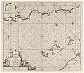
 Admiralty Chart No 1187 Alicante to Palamos with the Islas Baleares, Published 1882.jpg 16,187 × 11,087; 42.36 MB
-
 Admiralty Chart No 3276 Plans in The Islas Baleares, Published 1902.jpg 11,256 × 8,162; 5.36 MB
-
 ATLAS JUSTUS PERTHES 06.jpg 4,565 × 3,925; 9.09 MB
-
 Atlas Van der Hagen-KW1049B12 015-INSVLAE BALEARIDES et PYTIVSAE.jpeg 5,500 × 4,291; 2.29 MB
-

-
 Balearic Islands. Special Special strategic map - btv1b53189524k.jpg 9,070 × 7,908; 4.62 MB
-
 Carte des Baleares de la baie de Mahon et du fort Saint Philippe en 1740.jpg 1,616 × 643; 411 KB
-
-

-

-
 Iles Baleares. btv1b8439359b (cropped).jpg 3,171 × 1,686; 1.04 MB
-

-
 Insvlæ Balearides et Pytivsæ.jpg 4,735 × 4,093; 5.5 MB
-

-

-
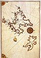 Majorca and Minorca by Piri Reis.jpg 570 × 810; 175 KB
-
 Map - Special Collections University of Amsterdam - OTM- HB-KZL 32.25.35.tif 7,336 × 6,324; 132.73 MB
-
 Map - Special Collections University of Amsterdam - OTM- HB-KZL 32.25.44.tif 7,784 × 6,580; 146.54 MB
-
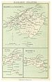 O'SHEAS (1895) p486 BALEARIC ISLANDS.jpg 1,209 × 1,903; 1.22 MB
-
-
 Piri Reis - Map of the Islands of Mojorca and Minorca - Walters W658233A - Full Page.jpg 1,214 × 1,799; 2.54 MB
-

-

-
 Senyeres atlas de Cresques.jpg 599 × 479; 66 KB
-
 The Balearic ïsles - btv1b550045397.jpg 7,116 × 5,389; 3.17 MB
-

.jpg)


_-_btv1b53227041w_(1_of_2).jpg)
.jpg)
.jpg)

.png)
.jpg)


_(14597917697).jpg)


re_d%27Etat_Commandeur_des_Ordres_du_Roi_-_par_N._B(ellin)_Ing%C3%A9nieur_au_D%C3%A9post_des_Cartes_et_Plans_de_la_Marine..._-_btv1b53056741k.jpg)
re_d%27Etat_Commandeur_des_Ordres_du_Roi_-_par_N._B(ellin)_Ing%C3%A9nieur_au_D%C3%A9post_des_Cartes_et_Plans_de_la_Marine..._-_btv1b59719126.jpg)

.jpg)
%27_(11230695924).jpg)

._Traduit_de_l%27allemand,_avec_l%27autorisation_de_l%27auteur_et_annot%C3%A9e_sous_la_direction_de_Emm._de_Margerie._Avec_une_pr%C3%A9f._par_Marcel_Bertrand_(1897)_(14591529100).jpg)


_p486_BALEARIC_ISLANDS.jpg)
,_RP-P-1896-A-19368-3070.jpg)


