Category:Old county maps of Leicestershire
Jump to navigation
Jump to search
Ceremonial counties of England: Bedfordshire · Berkshire · Buckinghamshire · Cambridgeshire · Cheshire · Cornwall · Derbyshire · Devon · Dorset · Durham · East Riding of Yorkshire · Essex · Gloucestershire · Hampshire · Herefordshire · Hertfordshire · Kent · Lancashire · Leicestershire · Lincolnshire · Norfolk · Northamptonshire · Northumberland · Nottinghamshire · Oxfordshire · Rutland · Shropshire · Somerset · Staffordshire · Suffolk · Surrey · Warwickshire · Wiltshire · Worcestershire
City-counties:
Former historic counties: Cumberland · Huntingdonshire · Middlesex · North Riding of Yorkshire · Sussex · West Riding of Yorkshire · Westmorland · Yorkshire
Other former counties:
City-counties:
Former historic counties: Cumberland · Huntingdonshire · Middlesex · North Riding of Yorkshire · Sussex · West Riding of Yorkshire · Westmorland · Yorkshire
Other former counties:
Media in category "Old county maps of Leicestershire"
The following 10 files are in this category, out of 10 total.
-

-

-
 "Leicestrensis comitatus, Leicester Shire" (21638909203).jpg 3,866 × 3,030; 2.04 MB
-

-
 Maps of England circa 1670, Leicester 22 of 40 (13432928824).jpg 6,333 × 4,983; 4.06 MB
-
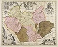 Leicestriensis comitatus cum Rutlandiae vulgo Leicester & Rutland Shire - CBT 6596842.jpg 5,911 × 4,715; 8.01 MB
-
 17th Century map of Leicestershire.JPG 3,456 × 2,592; 5.37 MB
-
 Aikin(1800) p174 - Leicestershire.jpg 1,173 × 1,600; 327 KB
-
 Gray1824.leics.jpg 787 × 982; 138 KB
-
 Pigot and Co (1842) p2.196 - Map of Leicestershire and Rutlandshire.jpg 2,144 × 1,310; 904 KB

.jpg)
.jpg)
.5.(27).jpg)
.jpg)


_p174_-_Leicestershire.jpg)

_p2.196_-_Map_of_Leicestershire_and_Rutlandshire.jpg)