Category:Maps of Warren County, Indiana
Jump to navigation
Jump to search
Counties of Indiana: Adams · Allen · Bartholomew · Benton · Blackford · Boone · Brown · Carroll · Cass · Clark · Clay · Clinton · Crawford · Daviess · Dearborn · Decatur · DeKalb · Delaware · Dubois · Elkhart · Fayette · Floyd · Fountain · Franklin · Fulton · Gibson · Grant · Greene · Hamilton · Hancock · Harrison · Hendricks · Henry · Howard · Huntington · Jackson · Jasper · Jay · Jefferson · Jennings · Johnson · Knox · Kosciusko · LaGrange · Lake · LaPorte · Lawrence · Madison · Marion · Marshall · Martin · Miami · Monroe · Montgomery · Morgan · Newton · Noble · Ohio · Orange · Owen · Parke · Perry · Pike · Porter · Posey · Pulaski · Putnam · Randolph · Ripley · Rush · Scott · Shelby · Spencer · St. Joseph · Starke · Steuben · Sullivan · Switzerland · Tippecanoe · Tipton · Union · Vanderburgh · Vermillion · Vigo · Wabash · Warren · Warrick · Washington · Wayne · Wells · White · Whitley
Wikimedia category | |||||
| Upload media | |||||
| Instance of | |||||
|---|---|---|---|---|---|
| Category combines topics | |||||
| Warren County | |||||
county in Indiana, United States   | |||||
| Instance of | |||||
| Named after | |||||
| Location | Indiana | ||||
| Capital | |||||
| Inception |
| ||||
| Population |
| ||||
| Area |
| ||||
| Different from | |||||
| official website | |||||
 | |||||
Subcategories
This category has only the following subcategory.
Media in category "Maps of Warren County, Indiana"
The following 57 files are in this category, out of 57 total.
-
 Baltimore, Indiana plat.png 2,800 × 2,400; 11.43 MB
-
 Foster, Indiana plat.png 2,750 × 1,600; 6.47 MB
-
 Kickapoo, Indiana plat.png 1,800 × 1,800; 4.07 MB
-
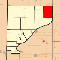
 Locator map of Warren County, Indiana.svg 896 × 768; 590 KB
-
 Map highlighting Adams Township, Warren County, Indiana.svg 512 × 512; 115 KB
-
 Map highlighting Jordan Township, Warren County, Indiana.svg 512 × 512; 115 KB
-
 Map highlighting Kent Township, Warren County, Indiana.svg 512 × 512; 116 KB
-
 Map highlighting Liberty Township, Warren County, Indiana.svg 512 × 512; 115 KB
-
 Map highlighting Medina Township, Warren County, Indiana.svg 512 × 512; 115 KB
-
 Map highlighting Mound Township, Warren County, Indiana.svg 512 × 512; 116 KB
-
 Map highlighting Pike Township, Warren County, Indiana.svg 512 × 512; 116 KB
-
 Map highlighting Pine Township, Warren County, Indiana.svg 512 × 512; 115 KB
-
 Map highlighting Prairie Township, Warren County, Indiana.svg 512 × 512; 115 KB
-
 Map highlighting Steuben Township, Warren County, Indiana.svg 512 × 512; 116 KB
-
 Map highlighting Warren Township, Warren County, Indiana.svg 512 × 512; 116 KB
-
 Map highlighting Washington Township, Warren County, Indiana.svg 512 × 512; 116 KB
-
 Map of Adams Township, Warren County, Indiana.svg 768 × 768; 173 KB
-
 Map of Indiana highlighting Warren County.svg 2,887 × 4,423; 56 KB
-
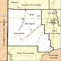
 Map of Jordan Township, Warren County, Indiana.svg 768 × 768; 219 KB
-
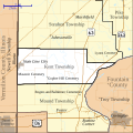 Map of Kent Township, Warren County, Indiana.svg 768 × 768; 362 KB
-
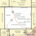 Map of Liberty Township, Warren County, Indiana.svg 768 × 768; 407 KB
-
 Map of Medina Township, Warren County, Indiana.svg 768 × 768; 195 KB
-
 Map of Mound Township, Warren County, Indiana.svg 768 × 768; 351 KB
-
 Map of Pike Township, Warren County, Indiana.svg 768 × 768; 373 KB
-
 Map of Pine Township, Warren County, Indiana.svg 768 × 768; 212 KB
-
 Map of Pine Village, Indiana.svg 768 × 768; 71 KB
-
 Map of Prairie Township, Warren County, Indiana.svg 768 × 768; 242 KB
-
 Map of State Line City, Indiana.svg 768 × 768; 34 KB
-
 Map of Steuben Township, Warren County, Indiana.svg 768 × 768; 481 KB
-
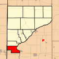
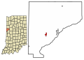
 Map of Warren County Indiana highlighting Adams Township.png 500 × 550; 27 KB
-
 Map of Warren County Indiana highlighting Jordan Township.png 500 × 550; 27 KB
-
 Map of Warren County Indiana highlighting Kent Township.png 500 × 550; 27 KB
-
 Map of Warren County Indiana highlighting Liberty Township.png 500 × 550; 27 KB
-
 Map of Warren County Indiana highlighting Medina Township.png 500 × 550; 27 KB
-
 Map of Warren County Indiana highlighting Mound Township.png 500 × 550; 27 KB
-
 Map of Warren County Indiana highlighting Pike Township.png 500 × 550; 27 KB
-
 Map of Warren County Indiana highlighting Pine Township.png 500 × 550; 27 KB
-
 Map of Warren County Indiana highlighting Prairie Township.png 400 × 440; 22 KB
-
 Map of Warren County Indiana highlighting Steuben Township.png 500 × 550; 27 KB
-
 Map of Warren County Indiana highlighting Warren Township.png 500 × 550; 27 KB
-
 Map of Warren County Indiana highlighting Washington Township.png 500 × 550; 26 KB
-
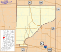
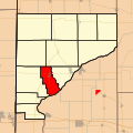
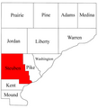
 Map of Warren County showing townships.png 500 × 550; 31 KB
-
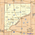 Map of Warren County, Indiana.svg 768 × 768; 583 KB
-
 Map of Warren Township, Warren County, Indiana.svg 768 × 768; 462 KB
-
 Map of Washington Township, Warren County, Indiana.svg 768 × 768; 490 KB
-
 Map of West Lebanon, Indiana.svg 768 × 768; 104 KB
-
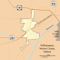 Map of Williamsport, Indiana.svg 768 × 768; 138 KB
-
 Pence, Indiana plat.png 1,650 × 2,000; 5.05 MB
-
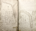
 Point Pleasant, Indiana plat.jpg 1,650 × 2,450; 2.74 MB
-

-

-

-
-

-

-

-
 Warren County Indiana Townships.png 1,024 × 1,126; 35 KB


