Category:Locator maps of counties of New Mexico
Jump to navigation
Jump to search

States of the United States: Alabama · Alaska · Arizona · Arkansas · California · Colorado · Connecticut · Delaware · Florida · Georgia · Hawaii · Idaho · Illinois · Indiana · Iowa · Kansas · Kentucky · Louisiana · Maine · Maryland · Massachusetts · Michigan · Minnesota · Mississippi · Missouri · Montana · Nebraska · Nevada · New Hampshire · New Jersey · New Mexico · New York · North Carolina · North Dakota · Ohio · Oklahoma · Oregon · Pennsylvania · Rhode Island · South Carolina · South Dakota · Tennessee · Texas · Utah · Vermont · Virginia · Washington · West Virginia · Wisconsin · Wyoming
| NO WIKIDATA ID FOUND! Search for Locator maps of counties of New Mexico on Wikidata | |
| Upload media |
English: Locator maps for counties in New Mexico.
Subcategories
This category has only the following subcategory.
R
Media in category "Locator maps of counties of New Mexico"
The following 33 files are in this category, out of 33 total.
-
 Map of New Mexico highlighting Bernalillo County.svg 5,677 × 6,312; 40 KB
-
 Map of New Mexico highlighting Catron County.svg 5,677 × 6,312; 36 KB
-
 Map of New Mexico highlighting Chaves County.svg 5,677 × 6,312; 39 KB
-
 Map of New Mexico highlighting Cibola County.svg 5,677 × 6,312; 40 KB
-
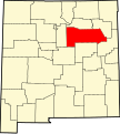
 Map of New Mexico highlighting Colfax County.svg 5,677 × 6,312; 38 KB
-
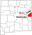 Map of New Mexico highlighting Curry County.svg 5,677 × 6,312; 35 KB
-
 Map of New Mexico highlighting De Baca County.svg 5,677 × 6,312; 39 KB
-
 Map of New Mexico highlighting Doña Ana County.svg 5,677 × 6,312; 35 KB
-
 Map of New Mexico highlighting Eddy County.svg 5,677 × 6,312; 36 KB
-
 Map of New Mexico highlighting Grant County.svg 5,677 × 6,312; 31 KB
-
 Map of New Mexico highlighting Guadalupe County.svg 5,677 × 6,312; 31 KB
-
 Map of New Mexico highlighting Harding County.svg 5,677 × 6,312; 31 KB
-
 Map of New Mexico highlighting Hidalgo County.svg 5,677 × 6,312; 31 KB
-
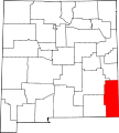 Map of New Mexico highlighting Lea County.svg 5,677 × 6,312; 31 KB
-
 Map of New Mexico highlighting Lincoln County.svg 5,677 × 6,312; 31 KB
-
 Map of New Mexico highlighting Los Alamos County.svg 5,677 × 6,312; 36 KB
-
 Map of New Mexico highlighting Luna County.svg 5,677 × 6,312; 31 KB
-
 Map of New Mexico highlighting McKinley County.svg 5,677 × 6,312; 31 KB
-
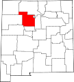
 Map of New Mexico highlighting Mora County.svg 5,677 × 6,312; 31 KB
-
 Map of New Mexico highlighting Otero County.svg 5,677 × 6,312; 31 KB
-
 Map of New Mexico highlighting Quay County.svg 5,677 × 6,312; 31 KB
-
 Map of New Mexico highlighting Rio Arriba County.svg 5,677 × 6,312; 31 KB
-
 Map of New Mexico highlighting Roosevelt County.svg 5,677 × 6,312; 31 KB
-
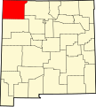 Map of New Mexico highlighting San Juan County.svg 5,677 × 6,312; 31 KB
-
 Map of New Mexico highlighting San Miguel County.svg 5,677 × 6,312; 31 KB
-
 Map of New Mexico highlighting Sandoval County.svg 5,677 × 6,312; 31 KB
-
 Map of New Mexico highlighting Santa Fe County.svg 5,677 × 6,312; 31 KB
-
 Map of New Mexico highlighting Sierra County.svg 5,677 × 6,312; 31 KB
-
 Map of New Mexico highlighting Socorro County.svg 5,677 × 6,312; 31 KB
-
 Map of New Mexico highlighting Taos County.svg 5,677 × 6,312; 31 KB
-
 Map of New Mexico highlighting Torrance County.svg 5,677 × 6,312; 31 KB
-
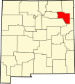
 Map of New Mexico highlighting Union County.svg 5,677 × 6,312; 31 KB
-
 Map of New Mexico highlighting Valencia County.svg 5,677 × 6,312; 31 KB


