From Wikimedia Commons, the free media repository
- Maps are also available as part of the
 Wikimedia Atlas of the World project in the Atlas of Switzerland.
-
-
-
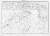
Map of Switzerland
-
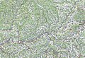
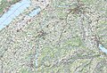
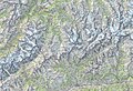
Simple topographical Map
-
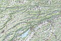
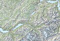
Simple topographical Map (Swisstopo)
-
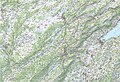
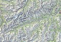
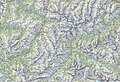
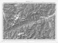
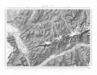
Detailed topographical Map (Swisstopo)
-
-
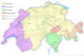
Cantons of Switzerland (in French)
-
Cantons of
Switzerland (in German)
1:25,000 topographical map
[edit]
Swisstopo Swiss Map Raster 25 map sheets
|
|
0
|
1
|
2
|
3
|
4
|
5
|
6
|
7
|
8
|
9
|
10
|
11
|
12
|
13
|
14
|
15
|
16
|
17
|
18
|
19
|
bis
|
| 1000
|
•
|
•
|
•
|
•
|
•
|
•
|
•
|
•
|
•
|
•
|
•
|

|

|
•
|
•
|
•
|
•
|
•
|
•
|
•
|
•
|
| 1020
|
•
|
•
|
•
|
•
|
•
|
•
|
•
|
•
|
•
|
•
|
•
|

|

|

|

|

|
•
|
•
|
•
|
•
|
•
|
| 1040
|
•
|
•
|
•
|
•
|
•
|
•
|
•
|

|

|

|

|

|

|

|

|

|

|
•
|
•
|
•
|
•
|
| 1060
|
•
|
•
|
•
|
•
|

|

|

|

|

|

|

|

|

|

|

|

|

|
•
|
•
|
•
|
•
|
| 1080
|
•
|
•
|
•
|
•
|

|

|

|

|

|

|

|

|

|

|

|

|

|
•
|
•
|
•
|
•
|
| 1100
|
•
|
•
|
•
|
•
|

|

|

|

|

|

|

|

|

|

|

|

|

|
•
|
•
|
•
|
•
|
| 1120
|
•
|
•
|
•
|

|

|

|

|

|

|

|

|

|

|

|

|

|

|
•
|
•
|
•
|
•
|
| 1140
|
•
|
•
|
•
|

|

|

|

|

|

|

|

|

|

|

|

|

|

|

|
•
|

|
•
|
| 1160
|
•
|
•
|

|

|

|

|

|

|

|

|

|

|

|

|

|

|

|

|

|

|
•
|
| 1180
|
•
|
•
|

|

|

|

|

|

|

|

|

|

|

|

|

|

|

|

|

|

|

|
| 1200
|
•
|

|

|

|

|

|

|

|

|

|

|

|

|

|

|

|

|

|

|

|

|
| 1220
|
•
|

|

|

|

|

|

|

|

|

|

|

|

|

|

|

|

|

|

|

|

|
| 1240
|

|

|

|

|

|

|

|

|

|

|

|

|

|

|

|

|

|

|

|
•
|
•
|
| 1260
|

|

|

|

|

|

|

|

|

|

|

|

|

|

|

|

|

|

|

|
•
|
•
|
| 1280
|

|

|
•
|
•
|

|

|

|

|

|

|

|

|

|

|

|
•
|

|
•
|

|
•
|
•
|
| 1300
|

|

|
•
|
•
|

|

|

|

|

|

|
•
|

|

|

|

|
•
|
•
|
•
|
•
|
•
|
•
|
| 1320
|
•
|
•
|
•
|
•
|

|

|

|

|

|

|
•
|
•
|

|

|
|
•
|
•
|
•
|
•
|
•
|
•
|
| 1340
|
•
|
•
|
•
|
•
|

|

|

|

|

|

|
•
|
•
|

|

|
•
|
•
|
•
|
•
|
•
|
•
|
•
|
| 1360
|
•
|
•
|
•
|
•
|
•
|

|

|
•
|
•
|
•
|
•
|
•
|
•
|

|

|
•
|
•
|
•
|
•
|
•
|
•
|
1:50,000 topographical map
[edit]
Swisstopo 1:50'000 map sheets, Swiss Map Raster 50
|
|
0
|
1
|
2
|
3
|
4
|
5
|
6
|
7
|
8
|
9
|
bis
|
| 200
|
|
|
|
|
|
|

|

|
|
|
|
| 210
|
|
|
|
|
|
|

|

|

|
|
|
| 220
|
|
|
|
|
|
|
|
|
|
|
|
| 230
|
|
|
|
|
|
|
|
|
|
|
|
| 240
|
|
|
|
|
|
|
|
|
|
|
|
| 250
|
|
|
|
|
|
|
|
|
|
|
|
| 260
|

|

|

|
|
|
|
|
|
|
|
|
| 270
|

|

|

|
|
|
|
|
|
|
|
|
| 280
|
|
|

|
|
|
|
|
|
|
|
|
| 290
|
|
|

|
|
|
|
|
|
|
|
|
1:100,000 topographical map
[edit]
Swisstopo Swiss Map Raster 100 sheets
|
|
0
|
1
|
2
|
3
|
4
|
| 25
|
|

|
|
|

|
| 30
|

|
|

|

|

|
| 35
|
|
|
|
|
|
| 40
|

|

|

|

|

|
| 45
|

|
|

|

|
|
1:200,000 topographical map
[edit]
Swisstopo Swiss Map Raster 200 tiles

|

|

|

|

|

|

|

|

|

|

|

|

|

|

|

|
en:History of Switzerland
-
Territorial development of the
Roman Empire 264 BC-192, including the conquest of present Switzerland
-
Map of the
Roman Empire in 50
-
The extent of the
Roman Republic and
Roman Empire;
44 BC (late Republic, after conquests by republican generals)
AD 14 (death of Augustus)
-
Camps of the Roman Legions in 80
-
Map of the
Roman Empire 116
-
-
-
Switzerland during the Roman period
-
-
The division of the Empire after the death of
Theodosius I, ca.395 AD superimposed on modern borders.
-
-
Invasions of the
Roman Empire 100-500
-
Invasions of the Roman Empire 100-500
-
-
Ecclesiastal divisions (1300)
-
The Old Swiss Confederacy from 1291 to the 16th century
-
Territorial development
-
Territorial development
-
-
The confederacy in 1315
-
The confederacy in 1385
-
Zurich War 1436-1450
-
The confederacy in 1474
-
Swabian War 1499
-
The confederacy in 1515
-
The comfederacy in 1536
-
Religions around 1536
-
Religions around 1700
-
The confederacy in the 18th century
-
Political structure of the confederacy 1474
-
Political structure of the confederacy 1530
-
Political structure of the confederacy 1560
-
Political structure of the confederacy in the 18th century
-
Sonderbund War 1847
-
Helvetian Republic 1798-1802
-
Religions around 1800
-
Die Eydtgnoschafft, Pünten und Wallis, Helvetia cum Confiniis, map from 1637
-
Die Eydtgnoschafft, Pünten und Wallis, Helvetia cum Confiniis, map from 1637 with colors
-
Map of Switzerland (1907, Diercke)
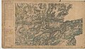
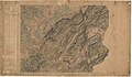
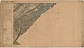
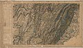
Topographische Karte der Schweiz 1:100'000 map sheets (1845—1865, Dufour map)

|

|

|

|
|

|

|

|

|

|

|

|

|
|

|

|
|

|

|

|
|

|

|

|

|
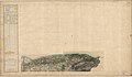
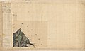
French Carte d'État-major (1866)
with border to Switzerland
|
|
|

|

|

|
|
|
|
|
|
|
|
|
|

|
|
|
|
|

|

|
|
|
|
|
|
|
|
|
|
|
|
|
|
|

|

|
|
|
|
|

|

|
|
|

|

|

|
|
|
|
|
|
|

|
|


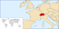 Location of Switzerland
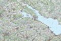
 Switzerland in Europe
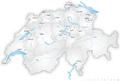 Map of Switzerland
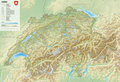 Simple topographical Map
 Simple topographical Map (Swisstopo)
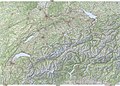 Detailed topographical Map (Swisstopo)
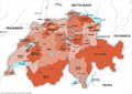 Cantons of Switzerland
 Cantons of Switzerland (in French)
 Cantons of Switzerland (in German)


 2002
2002 2016
2016
 Territorial development of the Roman Empire 264 BC-192, including the conquest of present Switzerland
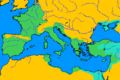 Map of the Roman Empire in 50
 The extent of the Roman Republic and Roman Empire;133 BC44 BC (late Republic, after conquests by republican generals)AD 14 (death of Augustus)117 (maximum extension)
 Camps of the Roman Legions in 80
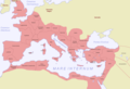 Map of the Roman Empire 116
 Roman Empire in 117
 Roman Empire in 117
 Switzerland during the Roman period
 Roman Empire divided 395
 The division of the Empire after the death of Theodosius I, ca.395 AD superimposed on modern borders.
 Invasions of the Roman Empire 100-500
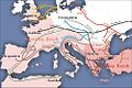 Invasions of the Roman Empire 100-500
 Alemannia and Upper Burgundy around AD 1000
 Ecclesiastal divisions (1300)
 The Old Swiss Confederacy from 1291 to the 16th century
 Territorial development
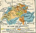 Territorial development
 The confederacy in 1315
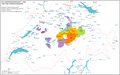 The confederacy in 1385
 Zurich War 1436-1450
 The confederacy in 1474
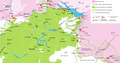 Swabian War 1499
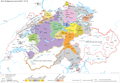 The confederacy in 1515
 The comfederacy in 1536
 Religions around 1536
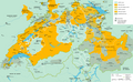 Religions around 1700
 The confederacy in the 18th century
 Political structure of the confederacy 1474
 Political structure of the confederacy 1530
 Political structure of the confederacy 1560
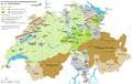 Political structure of the confederacy in the 18th century
 Sonderbund War 1847
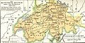 Helvetian Republic 1798-1802
 Religions around 1800


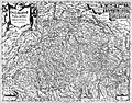 Die Eydtgnoschafft, Pünten und Wallis, Helvetia cum Confiniis, map from 1637
 Die Eydtgnoschafft, Pünten und Wallis, Helvetia cum Confiniis, map from 1637 with colors
 Map of Switzerland (1907, Diercke)


.jpg)
.jpg)
.jpg)
.jpg)
_Konstanz.jpg)
.jpg)
.jpg)
.jpg)
 Languages of Switzerland
 Languages of Switzerland
 Highways

