File:New England, New York, New Jersey and Pensilvania - by H. Moll, geographer. NYPL434019.tiff
Jump to navigation
Jump to search

Size of this JPG preview of this TIF file: 711 × 599 pixels. Other resolutions: 285 × 240 pixels | 570 × 480 pixels | 911 × 768 pixels | 1,215 × 1,024 pixels | 2,430 × 2,048 pixels | 4,632 × 3,904 pixels.
Original file (4,632 × 3,904 pixels, file size: 51.77 MB, MIME type: image/tiff)
Captions
Captions
Add a one-line explanation of what this file represents
Summary
[edit]| Description | New England, New York, New Jersey and Pensilvania / by H. Moll, geographer.; Maps of North America. / Countries / United States (except New York) / Parts | |||||||||||||||||||||||
| Notes | Covers areas north of Delaware Bay to Nova Scotia. ''Note 2.'') Includes note about the postal service. ''Note 3.'') National Endowment for the Humanities Grant for Access to Early Maps of the Middle Atlantic Seaboard. ''Note 4.'') On upper right corner: 49. ''Note 5.'') Prime meridian: London. ''Note 6.'') Probably from author's Atlas Minor. ''Note 7.'') Relief shown pictorially. ''Note 8.'') Shows rivers, boundaries, settlements, roads and woods. | |||||||||||||||||||||||
| Item physical description | 1 map : hand col. ; 20 x 26 cm. | |||||||||||||||||||||||
| Catalogue call number | Map Div. 01-5119 [Filed with New England, 1730?, as originally cataloged in NYPL Dictionary Catalog of the Map Division] | |||||||||||||||||||||||
| Date | circa 1732 | |||||||||||||||||||||||
| Source |
http://digitalgallery.nypl.org/nypldigital/dgkeysearchdetail.cfm?imageID=434019
|
|||||||||||||||||||||||
| Author |
|
|||||||||||||||||||||||
| Permission (Reusing this file) |
From The Lionel Pincus and Princess Firyal Map Division. http://maps.nypl.org
|
|||||||||||||||||||||||
| Location | Stephen A. Schwarzman Building / The Lionel Pincus and Princess Firyal Map Division | |||||||||||||||||||||||
| Digital item published | 2-3-2004; updated 3-25-2011 | |||||||||||||||||||||||
| Digital ID | 434019 | |||||||||||||||||||||||


The making of this file was supported by Wikimedia UK.
To see other files made with the support of Wikimedia UK, please see the category Supported by Wikimedia UK.
|
File history
Click on a date/time to view the file as it appeared at that time.
| Date/Time | Thumbnail | Dimensions | User | Comment | |
|---|---|---|---|---|---|
| current | 14:03, 6 November 2018 |  | 4,632 × 3,904 (51.77 MB) | SteinsplitterBot (talk | contribs) | Bot: Image rotated by 270° |
| 06:32, 2 May 2014 | 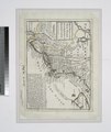 | 3,904 × 4,632 (51.74 MB) | Fæ (talk | contribs) | GWToolset:: Creating mediafile for Fæ. Tranche 3 11591-16518 @ 2 May, 06:47 BST |
You cannot overwrite this file.
File usage on Commons
There are no pages that use this file.