File:NPS capitol-reef-geologic-map.jpg
Jump to navigation
Jump to search

Size of this preview: 444 × 599 pixels. Other resolutions: 178 × 240 pixels | 356 × 480 pixels | 569 × 768 pixels | 759 × 1,024 pixels | 1,518 × 2,048 pixels | 4,222 × 5,695 pixels.
Original file (4,222 × 5,695 pixels, file size: 5.81 MB, MIME type: image/jpeg)
Captions
Captions
Add a one-line explanation of what this file represents
Summary
[edit]
| Description |
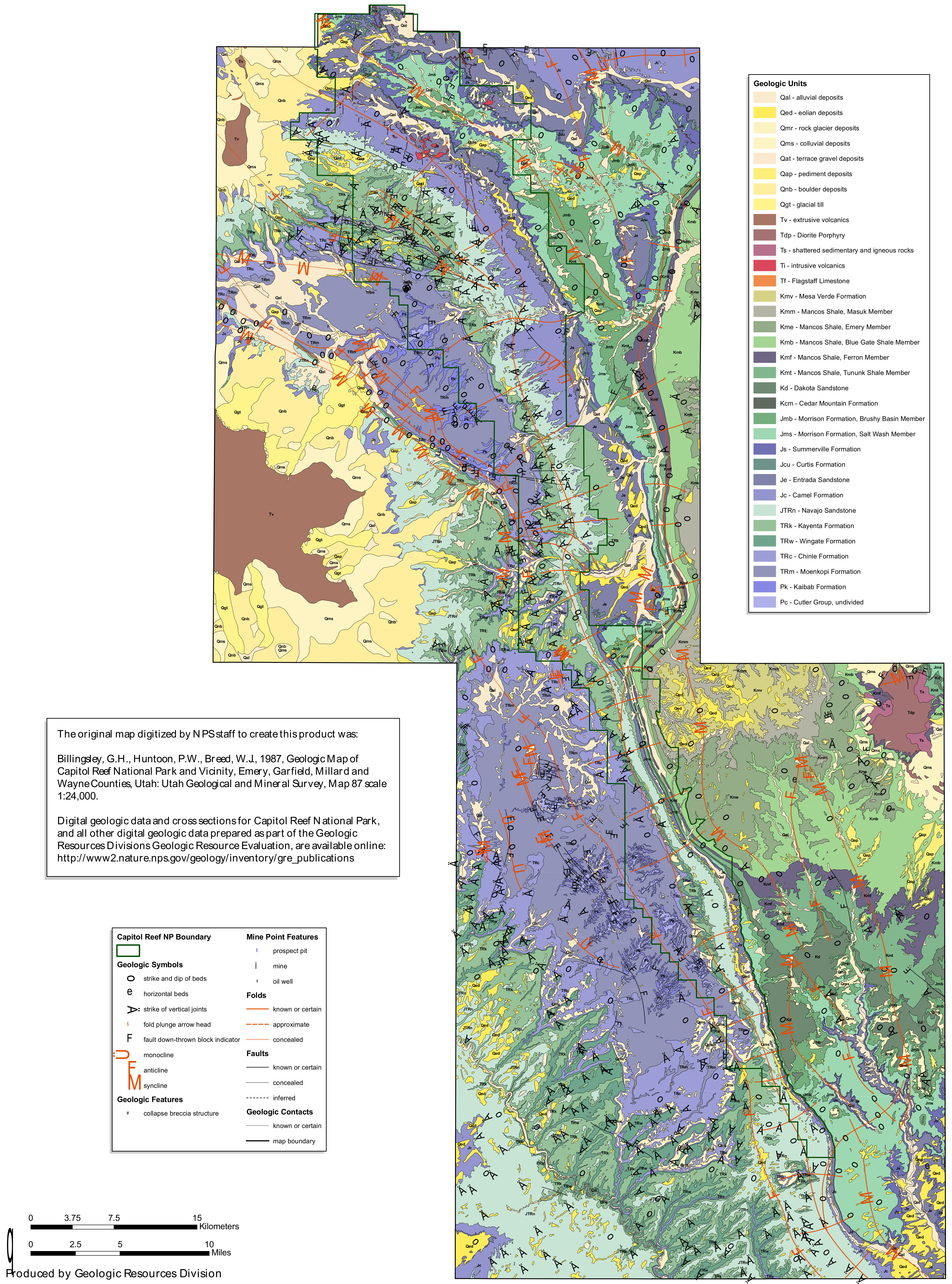
English: This Capitol Reef geologic map shows the folds and faults along the Waterpocket Fold, which makes up the backbone of Capitol Reef National Park. It’s more complicated than it looks in person, right? |
| Date | |
| Source | U.S. National Park Service (http://npmaps.com/wp-content/uploads/capitol-reef-geologic-map.jpg) |
| Author | U.S. National Park Service, restoration/cleanup by Matt Holly |
Licensing
[edit]
| This image or media file contains material based on a work of a National Park Service employee, created as part of that person's official duties. As a work of the U.S. federal government, such work is in the public domain in the United States. See the NPS website and NPS copyright policy for more information. |
File history
Click on a date/time to view the file as it appeared at that time.
| Date/Time | Thumbnail | Dimensions | User | Comment | |
|---|---|---|---|---|---|
| current | 20:01, 16 May 2017 | | 4,222 × 5,695 (5.81 MB) | RKBot (talk | contribs) | =={{int:filedesc}}== {{Information |description= {{en|1=This Capitol Reef geologic map shows the folds and faults along the Waterpocket Fold, which makes up the backbone of Capitol Reef National Park. It’s more complicated than it looks in person, ri... |
You cannot overwrite this file.
File usage on Commons
The following page uses this file:
Categories:
- Geological maps of Capitol Reef National Park
- Geological maps of Utah
- Quaternary alluvial deposits in Utah
- Quaternary aeolian deposits in Utah
- Quaternary rock glacier deposits in Utah
- Quaternary colluvial deposits in Utah
- Quaternary terrace gravel in Utah
- Quaternary pediment deposits in the United States
- Quaternary boulder deposits in Utah
- Quaternary glacial till in Utah
- Neogene eruption products in Utah
- Paleogene eruption products in Utah
- Neogene diorite formations in Utah
- Paleogene diorite formations in Utah
- Neogene sedimentary rocks in Utah
- Paleogene sedimentary rocks in Utah
- Neogene igneous rocks in Utah
- Paleogene igneous rocks in Utah
- Neogene igneous intrusions in Utah
- Paleogene igneous intrusions in Utah
- Flagstaff Formation (U.S. geology)
- Neogene breccia in Utah
- Paleogene breccia in Utah
- Mesaverde Group (geology) - maps
- Mesaverde Group (geology) in Utah
- Masuk Member, Mancos Shale
- Emery Member, Mancos Shale
- Blue Gate Shale Member, Mancos Shale
- Ferron Sandstone Member, Mancos Shale
- Tununk Member, Mancos Shale
- Mancos Shale maps
- Dakota Sandstone in Utah
- Dakota Sandstone maps
- Cedar Mountain Formation - maps
- Morrison Formation maps
- Morrison Formation in Utah
- Brushy Basin Member
- Salt Wash Member, Morrison Formation
- Summerville Formation in Utah
- Summerville Formation - maps
- Curtis Formation in Capitol Reef National Park
- Curtis Formation - maps
- Waterpocket Fold - geological maps
- Faults in Utah
- Folds in Utah
- Entrada Sandstone in Capitol Reef National Park
- Entrada Sandstone maps
- Carmel Formation - maps
- Navajo Sandstone maps
- Navajo Sandstone in Capitol Reef National Park
- Kayenta Formation - maps
- Kayenta Formation in Capitol Reef National Park
- Wingate Sandstone maps
- Wingate Sandstone in Capitol Reef National Park
- Chinle Formation maps
- Chinle Formation in Capitol Reef National Park
- Moenkopi Formation maps
- Moenkopi Formation in Capitol Reef National Park
- Kaibab Limestone maps
- Kaibab Limestone in Capitol Reef National Park
- Cutler Formation - maps
- Cutler Formation in Capitol Reef National Park