Category:Chinle Formation maps
Jump to navigation
Jump to search
Subcategories
This category has the following 5 subcategories, out of 5 total.
*
- Church Rock Member - maps (5 F)
- Owl Rock Member - maps (6 F)
Media in category "Chinle Formation maps"
The following 21 files are in this category, out of 21 total.
-
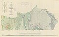 Baker 1936 USGS Bulletin 865 plate-1.jpg 17,361 × 10,939; 12.57 MB
-

-
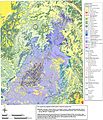
 Geologic map of Sanders quadrangle northern Arizona.jpg 6,042 × 11,567; 6.35 MB
-
 Gregory 1916 USGS Water Supply Paper 380 plate-2.jpg 12,200 × 9,600; 11.89 MB
-
 Gregory 1938 USGS Professional Paper 188 Plate 1.jpg 2,431 × 1,763; 1.22 MB
-
 Gregory 1938 USGS Professional Paper 188 Plate 17.jpg 2,068 × 2,493; 1.8 MB
-
 NE AZ-NW NM NASA.jpg 990 × 830; 645 KB
-
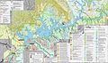
 NPS canyonlands-geologic-map.jpg 3,724 × 5,392; 6.02 MB
-
 NPS canyonlands-national-park-geologic-map.jpg 4,064 × 4,736; 5.19 MB
-
 NPS capitol-reef-geologic-map.jpg 4,222 × 5,695; 5.81 MB
-
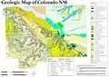 NPS colorado-national-monument-geologic-map.jpg 3,839 × 2,710; 1.9 MB
-
 NPS dinosaur-geologic-map.jpg 6,373 × 4,188; 6.03 MB
-
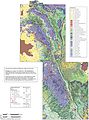
 NPS glen-canyon-geologic-map-central.jpg 3,143 × 1,859; 2.39 MB
-
 NPS glen-canyon-geologic-map-north.jpg 2,003 × 2,997; 2.24 MB
-
 NPS glen-canyon-geologic-map-south.jpg 3,145 × 1,865; 2.13 MB
-
 NPS petrified-forest-geologic-map-north.jpg 3,282 × 1,803; 1.09 MB
-
 NPS petrified-forest-geologic-map-south.jpg 2,608 × 2,954; 1.16 MB
-
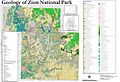 NPS zion-geologic-map.jpg 7,787 × 5,332; 10.96 MB
-
 O'Sullivan 1965 USGS Bulletin 1186 plate-1.jpg 8,600 × 5,900; 4.5 MB
-
 O'Sullivan 1965 USGS Bulletin 1186 plate-1.pdf 6,450 × 4,425; 9.19 MB
-
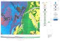
 USGS Lisbon Valley map.png 613 × 571; 42 KB


