File:Map Austria in the napoleonic age 1928-1940 - Touring Club Italiano CART-TRC-61.jpg
Jump to navigation
Jump to search

Size of this preview: 461 × 600 pixels. Other resolutions: 184 × 240 pixels | 369 × 480 pixels | 590 × 768 pixels | 787 × 1,024 pixels | 1,574 × 2,048 pixels | 5,056 × 6,579 pixels.
Original file (5,056 × 6,579 pixels, file size: 3.63 MB, MIME type: image/jpeg)
Captions
Captions
Add a one-line explanation of what this file represents
Summary
[edit]| Title |
Austria in the napoleonic age |
|
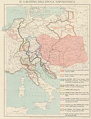
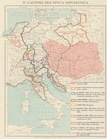
| Description |
English: The map depicts Austria in the napoleonic age. The map also shows the territories sold to other powers and states. The map is one of the tables made by the TCI Cartographic Office for the Italian Encyclopedia of Giovanni Treccani Italiano: La carta descrive l'Austria nell'età napoleonica. La carta mostra anche i territori ceduti alle altre potenze e stati. La mappa è una delle tavole eseguite dall'Ufficio Cartografico del TCI per l'Enciclopedia Italiana Giovanni Treccani |
|
| Date | between 1928 and 1940 | |
| Source | Scan from the original work Archivio Storico del Touring Club Italiano | |
| Creator |
TCI Cartographic Office |
|
| Permission (Reusing this file) |
|
|
| Geotemporal data | ||
| Date depicted | Early XVIIIst century | |
| Map location | Central Europe | |
| Map type | Maps showing history | |
| Scale | 1: 9 000 000 | |
| Georeferencing | If inappropriate please set warp_status = skip to hide. | |
| Bibliographic data | ||
| Part of the series | 1° Edition Italian Encyclopedia Giovanni Treccani | |
| Language | Italian | |
| Place of publication | Milan | |
| Publisher |
TCI |
|
| Printed by |
Vallardi |
|
| Archival data | ||
| Collection | ||
| Accession number |
CART.TRC.61 |
|

Licensing
[edit]
File history
Click on a date/time to view the file as it appeared at that time.
| Date/Time | Thumbnail | Dimensions | User | Comment | |
|---|---|---|---|---|---|
| current | 13:22, 20 October 2022 | | 5,056 × 6,579 (3.63 MB) | Marta Arosio (WMIT) (talk | contribs) | Cropped 10 % horizontally, 12 % vertically using CropTool with lossless mode. |
| 12:02, 20 October 2022 |  | 5,599 × 7,447 (4.34 MB) | Ilaria Parma (TCI) (talk | contribs) | pattypan 22.03 |
You cannot overwrite this file.
File usage on Commons
The following page uses this file:
File usage on other wikis
The following other wikis use this file:
- Usage on it.wikipedia.org
- Usage on sl.wikipedia.org
Metadata
Categories:
- Maps by TCI Cartographic Office
- Enciclopedia Treccani - Maps
- Touring Club Italiano maps showing history
- 1930s maps of Europe
- Maps of the history of Austria
- Maps of the history of Central Europe
- Maps of 18th-century Europe
- Maps of the Napoleonic Wars
- Italian-language maps showing history of Europe
- 1930s maps from Archivio Storico Touring Club Italiano