File:John Cary 1799 map of the territory of Bergamo.jpg
Jump to navigation
Jump to search

Size of this preview: 328 × 600 pixels. Other resolutions: 131 × 240 pixels | 262 × 480 pixels | 740 × 1,353 pixels.
Original file (740 × 1,353 pixels, file size: 420 KB, MIME type: image/jpeg)
Captions
Captions
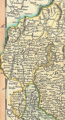
1799 map of the territory of Bergamo, by John Cary
| John Cary: A New Map of the County of Tyrol, and the Republic of Venice; Duchy of Mantua &c. &c. from the Latest Authorities.
( |
||||||||||||||||||||||||||
|---|---|---|---|---|---|---|---|---|---|---|---|---|---|---|---|---|---|---|---|---|---|---|---|---|---|---|
| Artist |
|
|||||||||||||||||||||||||
| Title |
A New Map of the County of Tyrol, and the Republic of Venice; Duchy of Mantua &c. &c. from the Latest Authorities. |
|||||||||||||||||||||||||
| Description |
English: An extremely attractive example of John Cary’s important 1799 map of the Venetian States. Covers Bergamo and Lake Constance eastward, past Tyrol, Venice, and Mantua to Istria and the Gulf of Trieste. Offers stupendous detail and color coding according to region. All in all, one of the most interesting and attractive atlas maps the Venice, Mantua and Tyrol to appear in first years of the 19th century. Prepared in 1799 by John Cary for issue in his magnificent 1808 New Universal Atlas . |
|||||||||||||||||||||||||
| Date | 1799 (dated) | |||||||||||||||||||||||||
| Dimensions | height: 18.5 in (46.9 cm); width: 21 in (53.3 cm) | |||||||||||||||||||||||||
| Accession number |
Geographicus link: Venice-cary-1799 |
|||||||||||||||||||||||||
| Source/Photographer |
Cary, John, Cary's New Universal Atlas, containing distinct maps of all the principal states and kingdoms throughout the World. From the latest and best authorities extant. London: Printed for J. Cary, Engraver and Map-seller, No. 181, near Norfolk Street, Strand, 1808.
|
|||||||||||||||||||||||||
| Permission (Reusing this file) |
|
|||||||||||||||||||||||||
| Other versions | ||||||||||||||||||||||||||

File history
Click on a date/time to view the file as it appeared at that time.
| Date/Time | Thumbnail | Dimensions | User | Comment | |
|---|---|---|---|---|---|
| current | 14:15, 17 October 2020 | | 740 × 1,353 (420 KB) | Dans (talk | contribs) | File:1799 Cary Map of Mantua, Venice and Tyrol, Italy - Geographicus - Venice-cary-1799.jpg cropped 85 % horizontally, 70 % vertically using CropTool with precise mode. |
You cannot overwrite this file.
File usage on Commons
The following 4 pages use this file: