File:Italy northern 1796.jpg
Original file (983 × 932 pixels, file size: 451 KB, MIME type: image/jpeg)
Captions
Captions
Summary
[edit]
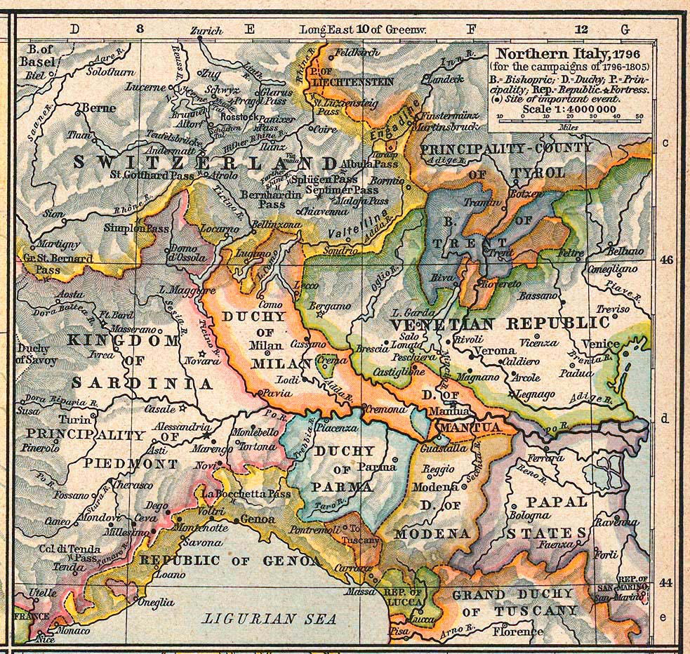
Courtesy of the University of Texas Libraries, The University of Texas at Austin.
| Description | Northern Italy, 1796 (for the campaigns of 1796-1805) | ||||||||||||||||||||||
| Date | |||||||||||||||||||||||
| Source | The Historical Atlas by William R. Shepherd, 1926 | ||||||||||||||||||||||
| Author |
|
||||||||||||||||||||||
| Permission (Reusing this file) |
Copyright expired | ||||||||||||||||||||||
| Other versions | http://www.lib.utexas.edu/maps/historical/shepherd/italy_northern_1796.jpg | ||||||||||||||||||||||
Licensing
[edit]
|
This work is in the public domain in its country of origin and other countries and areas where the copyright term is the author's life plus 70 years or fewer.
| |
| This file has been identified as being free of known restrictions under copyright law, including all related and neighboring rights. | |
File history
Click on a date/time to view the file as it appeared at that time.
| Date/Time | Thumbnail | Dimensions | User | Comment | |
|---|---|---|---|---|---|
| current | 15:34, 13 January 2017 | | 983 × 932 (451 KB) | Afnecors (talk | contribs) | colour improvement |
| 05:35, 8 April 2006 |  | 983 × 932 (389 KB) | Cave cattum (talk | contribs) | '''Courtesy of the University of Texas Libraries, The University of Texas at Austin.''' {{Information| |Description = Northern Italy, 1796 (for the campaigns of 1796-1805) |Source = The Historical Atlas by William R. Shepherd, 1926 |Date = 1926 |Author = |
You cannot overwrite this file.
File usage on Commons
The following 8 pages use this file:
File usage on other wikis
The following other wikis use this file:
- Usage on ar.wikipedia.org
- Usage on ast.wikipedia.org
- Usage on azb.wikipedia.org
- Usage on be.wikipedia.org
- Usage on bg.wikipedia.org
- Usage on br.wikipedia.org
- Usage on ca.wikipedia.org
- Usage on cs.wikipedia.org
- Usage on da.wikipedia.org
- Usage on de.wikipedia.org
- Usage on el.wikipedia.org
- Usage on eml.wikipedia.org
- Usage on en.wikipedia.org
View more global usage of this file.
Metadata
- Maps showing history by William R. Shepherd
- Mantuan State
- Maps of the Duchy of Ferrara
- Maps of the Austrian Lombardy
- Maps of the Republic of Lucca
- Old maps of the Republic of Genoa
- Maps of the Prince-Bishopric of Trent
- Maps of the Kingdom of Sardinia
- Maps of the Republic of Venice
- Maps of 18th-century Italy
- 1926 maps of Italy