File:Geological map of northwest USA showing Basin and Range faults and basalts and rhyolites up to17 Ma.png
Jump to navigation
Jump to search

Size of this preview: 447 × 599 pixels. Other resolutions: 179 × 240 pixels | 358 × 480 pixels | 573 × 768 pixels | 1,040 × 1,394 pixels.
Original file (1,040 × 1,394 pixels, file size: 1.24 MB, MIME type: image/png)
Captions
Captions
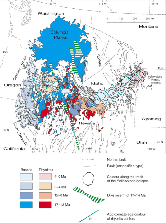
Geological map of northwest USA showing Basin and Range faults and basalts and rhyolites up to 17 Ma.
Summary
[edit]
| Description |
English: Geological map of northwest USA showing Basin and Range faults and basalts and rhyolites up to 17 Ma.
Blue lines represent approximate age contours of rhyolitic volcanic centres across the Eastern Snake River Plain and a contemporaneous trend of oppositely propagating rhyolitic volcanism across central Oregon. |
| Date | |
| Source | Christiansen, R. L., G. R. Foulger, and J. R. Evans, 2002, Upper mantle origin of the Yellowstone hotspot: Bulletin of the Geological Society of America, 114, 1245-1256. |
| Author | R.L. Christiansen et al |
Licensing
[edit]
This file is licensed under the Creative Commons Attribution-Share Alike 4.0 International license.
- You are free:
- to share – to copy, distribute and transmit the work
- to remix – to adapt the work
- Under the following conditions:
- attribution – You must give appropriate credit, provide a link to the license, and indicate if changes were made. You may do so in any reasonable manner, but not in any way that suggests the licensor endorses you or your use.
- share alike – If you remix, transform, or build upon the material, you must distribute your contributions under the same or compatible license as the original.
File history
Click on a date/time to view the file as it appeared at that time.
| Date/Time | Thumbnail | Dimensions | User | Comment | |
|---|---|---|---|---|---|
| current | 20:11, 15 December 2020 | | 1,040 × 1,394 (1.24 MB) | SphericalSong (talk | contribs) | Uploaded a work by R.L. Christiansen et al from Christiansen, R. L., G. R. Foulger, and J. R. Evans, 2002, Upper mantle origin of the Yellowstone hotspot: Bulletin of the Geological Society of America, 114, 1245-1256. with UploadWizard |
You cannot overwrite this file.
File usage on Commons
There are no pages that use this file.
File usage on other wikis
The following other wikis use this file:
- Usage on en.wikipedia.org
Metadata
Categories:
- Geological maps of the United States
- Columbia Plateau
- Holocene rhyolite formations in the United States
- Holocene basalt formations in the United States
- Pleistocene rhyolite formations in the United States
- Pleistocene basalt formations in the United States
- Pliocene rhyolite formations in the United States
- Pliocene basalt formations in the United States
- Miocene rhyolite formations in the United States
- Miocene basalt formations in the United States
- Faults in the United States
- Yellowstone hotspot
- Maps of the Snake River Plain
- Geological maps of Idaho
- Geological maps of Wyoming
- Geological maps of Nevada
- Geological maps of California
- Geological maps of Oregon
- Geological maps of Washington (state)
- Miocene dike swarms in the United States
- Geological maps of Montana
- Volcanological maps of the United States
- Basin and Range geology
- Basin and Range Province
- Dike swarms of the Columbia River Basalt Group