File:AMH-5653-KB Map of the southern part of the African continent.jpg
Jump to navigation
Jump to search
Size of this preview: 770 × 600 pixels. Other resolutions: 308 × 240 pixels | 616 × 480 pixels | 986 × 768 pixels | 1,280 × 997 pixels | 2,400 × 1,870 pixels.
Original file (2,400 × 1,870 pixels, file size: 606 KB, MIME type: image/jpeg)
Captions
Captions
Add a one-line explanation of what this file represents
Summary
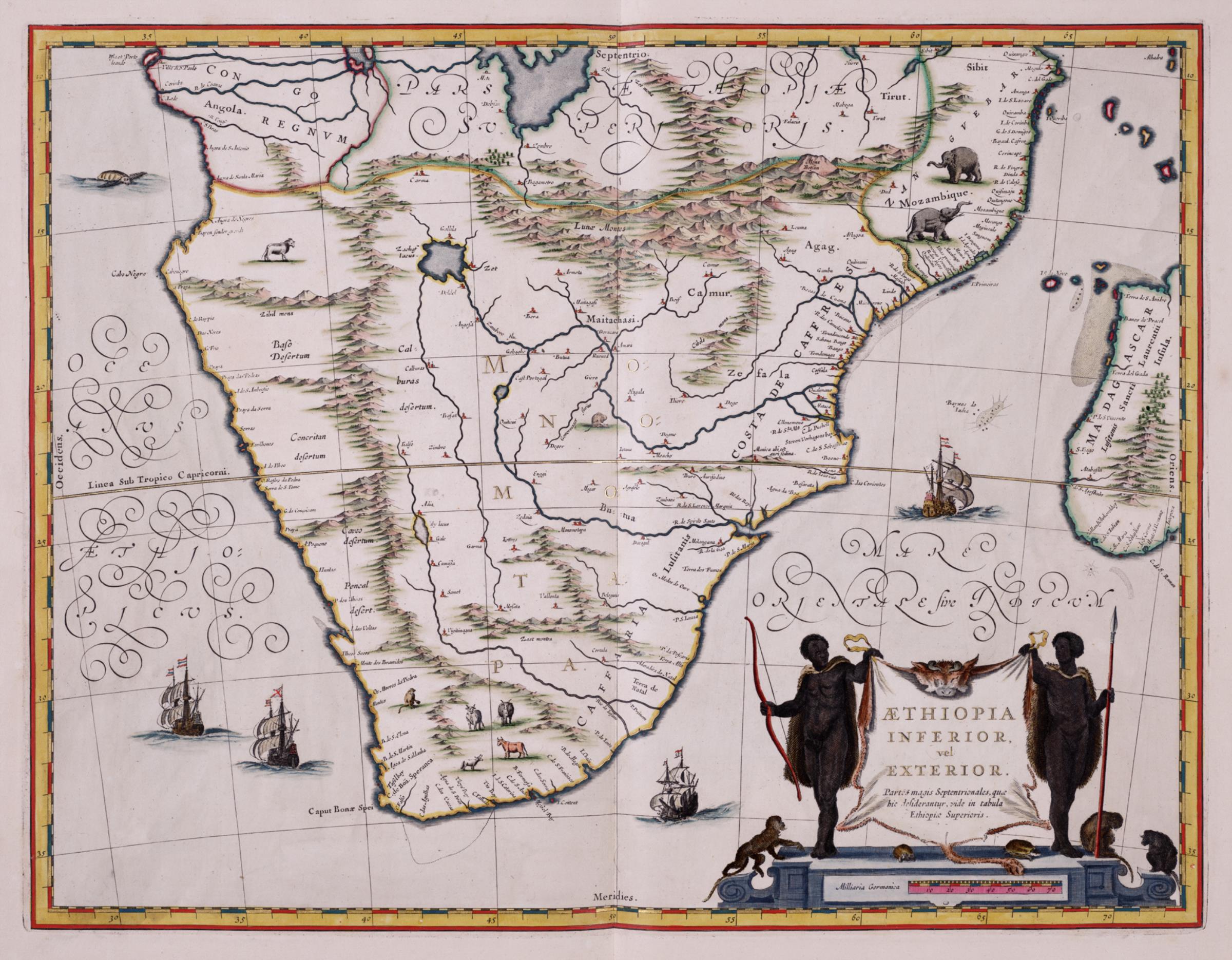
[edit]Nederlands: Kaart van het zuidelijk deel van het continent Afrika
English: Map of the southern part of the African continent( |
|||||||||||||||||||||||||||||||||||||||||||||||
|---|---|---|---|---|---|---|---|---|---|---|---|---|---|---|---|---|---|---|---|---|---|---|---|---|---|---|---|---|---|---|---|---|---|---|---|---|---|---|---|---|---|---|---|---|---|---|---|
| Author |
Nederlands: Wilhelm (Jansz.) Blaeu (uitgever), Abraham Ortelius (gewerkt naar)
English: Wilhelm (Jansz.) Blaeu (publisher), Abraham Ortelius (copied after) |
||||||||||||||||||||||||||||||||||||||||||||||
| Title |
Nederlands: Kaart van het zuidelijk deel van het continent Afrika
English: Map of the southern part of the African continent |
||||||||||||||||||||||||||||||||||||||||||||||
| Description |
Nederlands: Kaart van het zuidelijk deel van het continent Afrika uit de Atlas van der Hagen, Koninklijke Bibliotheek, Den Haag Deel 4.
Deze kaart van Willem Jansz. Blaeu (1571-1638) gold in de 17de eeuw als het model waarnaar vele kaarten van Zuid-Afrika werden gekopieerd. De kaart is voor een deel gebaseerd op de kaart het Koninkrijk van Prester John van Abraham Ortelius (1527-1598) uit 1573. Volgens oude legenden bevond zich ergens in het onbekende binnenlanden van Afrika een christelijk koninkrijk. De oostkust van Afrika is vrij nauwkeurig weergegeven waarbij Blaeu vermoedelijk gebruik maakte van Portugese bronnen. De twee grote meren iets onder de evenaar, heeft Blaeu ontleend aan beschrijvingen van de geograaf Ptolemaeus uit de 2e eeuw na Christus. Ze werden beschouwd als de bronnen van de Nijl.
English: Map of the southern part of the African continent taken from the Atlas van der Hagen, Koninklijke Bibliotheek, The Hague, Part 4.
During the 17th century this chart by Willem Jansz. Blaeu (1571-1638) functioned as a blueprint from which many maps of southern Africa were copied. The chart is partly based on the map of the Kingdom of Prester John drawn by Abraham Ortelius (1527-1598) in 1573. According to legend, somewhere deep in the unknown African interior there was a Christian kingdom. The east coast of Africa is rendered fairly accurately, and it is thought that Blaeu drew from Portuguese sources. The two great lakes situated just below the equator were taken by Blaeu from descriptions recorded by the geographer Ptolemaeus in the second century AD. These lakes were deemed to be the sources of the Nile. |
||||||||||||||||||||||||||||||||||||||||||||||
| Date | 1635 | ||||||||||||||||||||||||||||||||||||||||||||||
| Medium |
Nederlands: koperdruk op papier
English: copperplate printing on paper |
||||||||||||||||||||||||||||||||||||||||||||||
| Dimensions | height: 50 cm (19.6 in); width: 38 cm (14.9 in) | ||||||||||||||||||||||||||||||||||||||||||||||
| Collection |
|
||||||||||||||||||||||||||||||||||||||||||||||
| Accession number |
1049B13_066 |
||||||||||||||||||||||||||||||||||||||||||||||
| Inscriptions |
AETHIOPIA INFERIOR, vel EXTERIOR. Partes magis Septentrionalis, quae hic desiderantur, vide in tabula Ethiopiae Superioris
|
||||||||||||||||||||||||||||||||||||||||||||||
| Notes |
English: Subjects: chart / map / plan, ship / vessel, Asians & Africans, banderole / cartouche / ornamentation, fauna, Person
Nederlands: Onderwerpen: plattegrond / kaart, schip / vaartuig, Aziaten & Afrikanen, banderol / cartouche / versiering, fauna, Persoon |
||||||||||||||||||||||||||||||||||||||||||||||
| Source/Photographer |
|
||||||||||||||||||||||||||||||||||||||||||||||
| Permission (Reusing this file) |
|
||||||||||||||||||||||||||||||||||||||||||||||


File history
Click on a date/time to view the file as it appeared at that time.
| Date/Time | Thumbnail | Dimensions | User | Comment | |
|---|---|---|---|---|---|
| current | 11:02, 10 June 2014 | | 2,400 × 1,870 (606 KB) | HuskyBot (talk | contribs) | == {{int:filedesc}} == {{Artwork |title = {{nl|1=Kaart van het zuidelijk deel van het continent Afrika}} {{en|1=Map of the southern part of the African continent}} |description = {{nl|1=Kaart van het zuidelijk... |
You cannot overwrite this file.
File usage on Commons
The following page uses this file: