Category:Maps of the Dutch East India Company - Madagascar
Jump to navigation
Jump to search
Media in category "Maps of the Dutch East India Company - Madagascar"
The following 16 files are in this category, out of 16 total.
-
 AMH-5107-NA Map of Lagoa Bay up to the north of Soffala and a part of Madagascar.jpg 2,400 × 1,703; 263 KB
-
 AMH-5191-NA Map of the Cape of Good Hope up to and including Japan.jpg 2,400 × 1,724; 787 KB
-
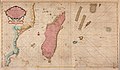
 AMH-5194-NA Map of Madagascar, with an insert showing the island of Bourbon.jpg 1,699 × 2,400; 562 KB
-
 AMH-5197-NA Map of part of the west coast of Madagascar.jpg 1,825 × 2,400; 577 KB
-
 AMH-5500-NA Seachart of Mozambique and Madagascar.jpg 2,400 × 1,407; 706 KB
-
 AMH-5622-NA Map of southern Africa and Madagascar.jpg 2,400 × 1,636; 898 KB
-
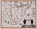 AMH-5653-KB Map of the southern part of the African continent.jpg 2,400 × 1,870; 606 KB
-
 AMH-5655-KB Map of Madagascar.jpg 2,400 × 1,879; 543 KB
-

-
 AMH-6637-KB Map of Madagascar with four inserts.jpg 2,400 × 1,642; 1,003 KB
-
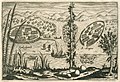 AMH-6638-KB View of the settlements of Spakenbourch and S. Angero on Madagascar.jpg 2,400 × 1,640; 1.24 MB
-
 AMH-6678-KB Map of Madagascar.jpg 2,400 × 1,865; 1.04 MB
-
 AMH-6873-KB Map of Madagascar.jpg 2,400 × 1,899; 918 KB
-
 AMH-7277-KB The river of Maningaar on Madagascar.jpg 2,400 × 1,849; 830 KB
-
 AMH-7428-KB Map of the southwestern part of the Indian Ocean.jpg 2,400 × 1,580; 498 KB
-
 AMH-7923-KB Map of part of the African east coast and Madagascar.jpg 2,400 × 2,115; 933 KB


