File:1799 Cary Map of Mantua, Venice and Tyrol, Italy - Geographicus - Venice-cary-1799.jpg
Jump to navigation
Jump to search
Size of this preview: 664 × 599 pixels. Other resolutions: 266 × 240 pixels | 532 × 480 pixels | 851 × 768 pixels | 1,135 × 1,024 pixels | 2,269 × 2,048 pixels | 5,000 × 4,513 pixels.
Original file (5,000 × 4,513 pixels, file size: 8.31 MB, MIME type: image/jpeg)
Captions
Captions
Add a one-line explanation of what this file represents
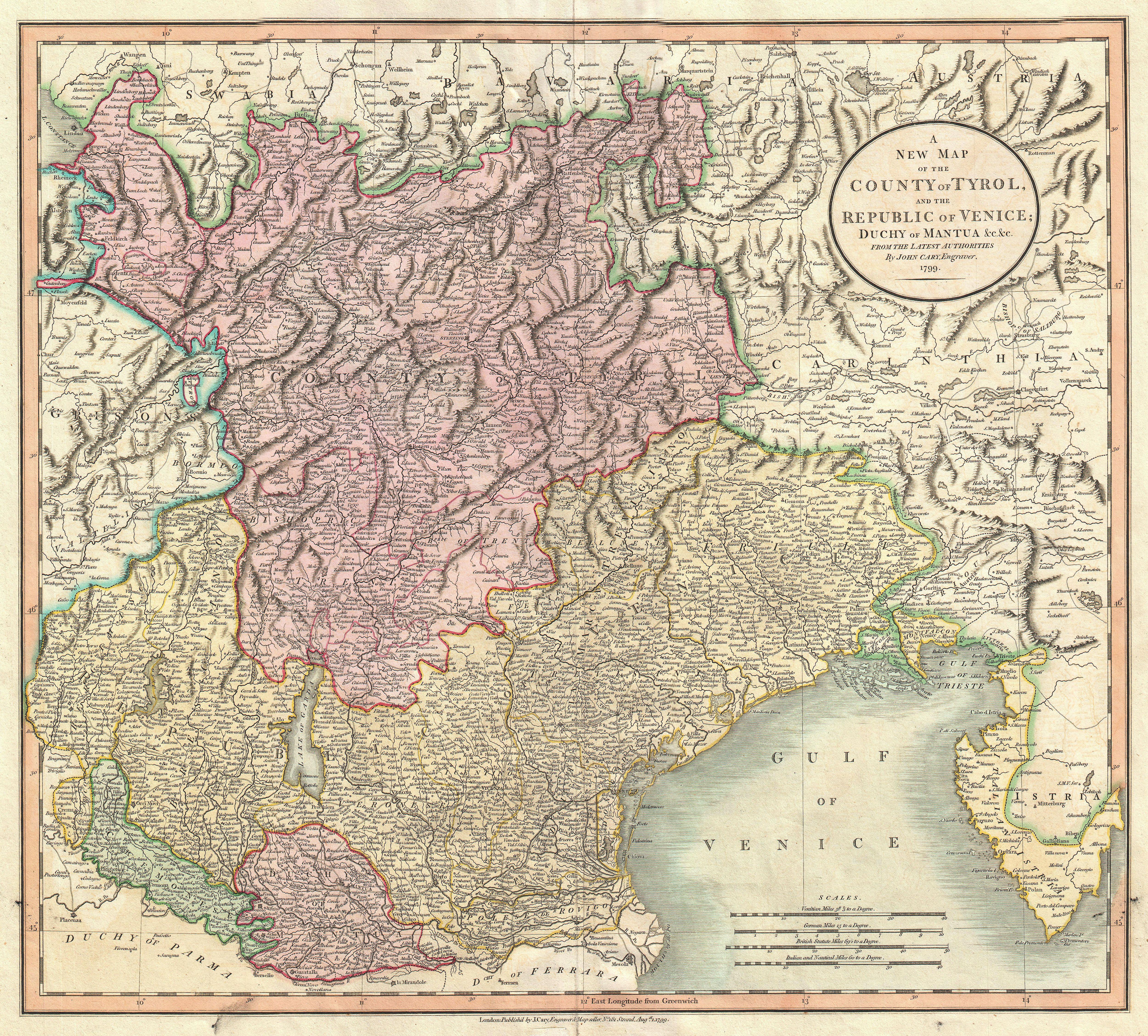
| John Cary: A New Map of the County of Tyrol, and the Republic of Venice; Duchy of Mantua &c. &c. from the Latest Authorities.
( |
||||||||||||||||||||||||||
|---|---|---|---|---|---|---|---|---|---|---|---|---|---|---|---|---|---|---|---|---|---|---|---|---|---|---|
| Artist |
|
|||||||||||||||||||||||||
| Title |
A New Map of the County of Tyrol, and the Republic of Venice; Duchy of Mantua &c. &c. from the Latest Authorities. |
|||||||||||||||||||||||||
| Description |
English: An extremely attractive example of John Cary’s important 1799 map of the Venetian States. Covers Bergamo and Lake Constance eastward, past Tyrol, Venice, and Mantua to Istria and the Gulf of Trieste. Offers stupendous detail and color coding according to region. All in all, one of the most interesting and attractive atlas maps the Venice, Mantua and Tyrol to appear in first years of the 19th century. Prepared in 1799 by John Cary for issue in his magnificent 1808 New Universal Atlas . |
|||||||||||||||||||||||||
| Date | 1799 (dated) | |||||||||||||||||||||||||
| Dimensions | height: 18.5 in (46.9 cm); width: 21 in (53.3 cm) | |||||||||||||||||||||||||
| Accession number |
Geographicus link: Venice-cary-1799 |
|||||||||||||||||||||||||
| Source/Photographer |
Cary, John, Cary's New Universal Atlas, containing distinct maps of all the principal states and kingdoms throughout the World. From the latest and best authorities extant. London: Printed for J. Cary, Engraver and Map-seller, No. 181, near Norfolk Street, Strand, 1808.
|
|||||||||||||||||||||||||
| Permission (Reusing this file) |
|
|||||||||||||||||||||||||
| Other versions | ||||||||||||||||||||||||||

| Annotations | This image is annotated: View the annotations at Commons |
File history
Click on a date/time to view the file as it appeared at that time.
| Date/Time | Thumbnail | Dimensions | User | Comment | |
|---|---|---|---|---|---|
| current | 11:01, 22 March 2011 | | 5,000 × 4,513 (8.31 MB) | BotMultichillT (talk | contribs) | {{subst:User:Multichill/Geographicus |link=http://www.geographicus.com/P/AntiqueMap/Venice-cary-1799 |product_name=1799 Cary Map of Mantua, Venice and Tyrol, Italy |map_title=A New Map of the County of Tyrol, and the Republic of Venice; Duchy of Mantua &c |
You cannot overwrite this file.
File usage on Commons
The following 4 pages use this file:
File usage on other wikis
The following other wikis use this file:
- Usage on it.wikipedia.org
Categories:
- County of Tyrol
- Maps by John Cary
- 1799 maps
- Old maps of the Tyrol
- English-language maps of Europe
- Maps of the Republic of Venice
- Maps of 18th-century Italy
- Old maps of Trentino-South Tyrol
- Old maps of Veneto
- Old maps of Friuli-Venezia Giulia
- Maps of the Gulf of Venice
- Stella (river)
- Maps of Caorle
- Laguna di Marano
- Lemene
- Mestre
- Maps of the Brenta River