Category:United Kingdom photographs taken on 2006-07-25
Jump to navigation
Jump to search

Subcategories
This category has the following 2 subcategories, out of 2 total.
Media in category "United Kingdom photographs taken on 2006-07-25"
The following 200 files are in this category, out of 778 total.
(previous page) (next page)-
 05-British Museum-001.jpg 3,264 × 2,448; 4.16 MB
-
 05-British Museum-002.jpg 3,152 × 2,113; 5.43 MB
-
 05-British Museum-059.jpg 3,264 × 2,448; 3.76 MB
-
 05-British Museum-060.jpg 2,448 × 3,264; 5.46 MB
-
 66171 Castleton East Junction.jpg 1,024 × 768; 661 KB
-
 66232 Castleton East Junction.jpg 1,024 × 768; 541 KB
-
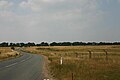
 A Berwickshire lane - geograph.org.uk - 208846.jpg 640 × 480; 84 KB
-
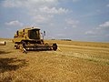
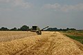
 A Combined Harvester At Work - geograph.org.uk - 210563.jpg 640 × 480; 109 KB
-
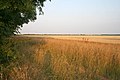
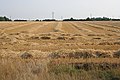
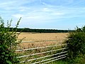 A Gate, Some Barley And A Wood - geograph.org.uk - 210901.jpg 640 × 480; 106 KB
-
 A new New Holland - geograph.org.uk - 208860.jpg 640 × 480; 73 KB
-
 A Permissive Path - geograph.org.uk - 211037.jpg 640 × 480; 111 KB
-
 A Polygamous Bull - geograph.org.uk - 210190.jpg 640 × 480; 108 KB
-
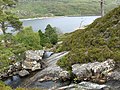
 A remote corner of Scotland - geograph.org.uk - 322323.jpg 600 × 400; 42 KB
-
 A Splash Of Red - geograph.org.uk - 209046.jpg 640 × 480; 106 KB
-
 A Track In Wath - geograph.org.uk - 211200.jpg 640 × 480; 109 KB
-
 A Track Into South Wood - geograph.org.uk - 211633.jpg 640 × 480; 103 KB
-
 A Tree Nursery - geograph.org.uk - 211025.jpg 640 × 480; 106 KB
-
 A visit from the Puncture Fairy - geograph.org.uk - 208690.jpg 640 × 480; 106 KB
-
 A534 Canal Bridge - geograph.org.uk - 208893.jpg 640 × 480; 50 KB
-
 A92 Crossing with the FandB Way - geograph.org.uk - 220942.jpg 640 × 373; 114 KB
-
 Ackling Dyke (Roman Road) - geograph.org.uk - 208473.jpg 640 × 481; 154 KB
-
 Ackling Dyke - geograph.org.uk - 208470.jpg 640 × 481; 134 KB
-
 After the harvest - geograph.org.uk - 209487.jpg 640 × 427; 45 KB
-
 Agriculture and Industry - geograph.org.uk - 209054.jpg 640 × 427; 54 KB
-
 Akenshaw Burn, Kielder Forest - geograph.org.uk - 209683.jpg 480 × 640; 121 KB
-
 Allt Coire Eoghainn - geograph.org.uk - 214152.jpg 640 × 478; 140 KB
-
 Allt Fraoch-choire - geograph.org.uk - 214162.jpg 640 × 478; 188 KB
-

-
 Anchors in Kings Lynn.JPG 2,186 × 1,912; 768 KB
-
 Approaching West Barn Farm - geograph.org.uk - 208912.jpg 640 × 480; 160 KB
-
 Arriving at Bargoed Railway Station. - geograph.org.uk - 806467.jpg 640 × 421; 102 KB
-
 B1112 at Foxhole Heath - geograph.org.uk - 208501.jpg 640 × 427; 45 KB
-
 Back of Pelaw Metro - geograph.org.uk - 208447.jpg 640 × 480; 109 KB
-
 Balmeadow Hill - geograph.org.uk - 208711.jpg 640 × 424; 69 KB
-
 Baltersan Castle - geograph.org.uk - 208625.jpg 640 × 480; 62 KB
-
 Beach at Cullen - geograph.org.uk - 924327.jpg 640 × 480; 67 KB
-
 Below Craig Hen-gae - geograph.org.uk - 216139.jpg 640 × 640; 156 KB
-
 Beware of the bull... - geograph.org.uk - 209918.jpg 640 × 480; 99 KB
-
 Bin Day - geograph.org.uk - 210512.jpg 640 × 480; 93 KB
-
 Black Rocks - geograph.org.uk - 209370.jpg 640 × 480; 124 KB
-

-
 Boatbuilders Yard in Buckie - geograph.org.uk - 924277.jpg 640 × 480; 58 KB
-
 Boatbuilders Yard in Buckie - geograph.org.uk - 924279.jpg 640 × 480; 76 KB
-
 Bodmin to Wenfordbridge railway - geograph.org.uk - 1095387.jpg 640 × 480; 104 KB
-
 Bond's Glen - geograph.org.uk - 209613.jpg 640 × 479; 47 KB
-
 Bond's Glen Road - geograph.org.uk - 209606.jpg 640 × 479; 93 KB
-
 Bonds Glen - geograph.org.uk - 209601.jpg 640 × 478; 64 KB
-
 Bonds Glen - geograph.org.uk - 209604.jpg 640 × 479; 76 KB
-
 Bonds Glen Restaurant - geograph.org.uk - 209598.jpg 640 × 479; 52 KB
-
 Bowling Green - geograph.org.uk - 208523.jpg 640 × 480; 104 KB
-
 Bramley Farm from Bramley lane - geograph.org.uk - 208765.jpg 640 × 480; 74 KB
-
 Breach Drove - geograph.org.uk - 208521.jpg 640 × 451; 75 KB
-

-
 Bridge over the Deadwater Burn - geograph.org.uk - 210189.jpg 640 × 480; 97 KB
-
 Bridle Stile, Shelf - geograph.org.uk - 209557.jpg 640 × 480; 118 KB
-
 Bridle Stile, Shelf - geograph.org.uk - 209572.jpg 640 × 480; 91 KB
-
 Bringing in the hay at Old Castleton - geograph.org.uk - 209923.jpg 640 × 480; 85 KB
-
 British Museum 20060725 001.jpg 3,264 × 2,448; 5.29 MB
-
 British Museum, Library 20060725 001.jpg 2,843 × 2,132; 6.08 MB
-
 Broadings Farm - geograph.org.uk - 209045.jpg 640 × 427; 60 KB
-
 Brow Lane, Shelf - geograph.org.uk - 209566.jpg 640 × 480; 94 KB
-
 A Footpath To High Stittenham - geograph.org.uk - 210567.jpg 640 × 480; 108 KB
-
 A Footpath To Thornton Le Clay - geograph.org.uk - 209042.jpg 640 × 480; 105 KB
-
 Bwlch Gwyn looking inland - geograph.org.uk - 209382.jpg 640 × 480; 136 KB
-
 By Gathercauld - geograph.org.uk - 208653.jpg 640 × 424; 89 KB
-
 By Johnstone and Dun Bog - geograph.org.uk - 208700.jpg 640 × 424; 64 KB
-
 By Letham - geograph.org.uk - 208662.jpg 640 × 424; 56 KB
-
 Calverton Lane Caravan Park - geograph.org.uk - 208777.jpg 640 × 480; 116 KB
-
 Capel Bethania - geograph.org.uk - 212072.jpg 640 × 530; 83 KB
-
 Carnach in Glen Elchaig - geograph.org.uk - 760220.jpg 480 × 640; 82 KB
-
 Castle at Manorbier - geograph.org.uk - 363771.jpg 640 × 480; 90 KB
-
 Cattle near Sorbietrees, Newcastleton - geograph.org.uk - 208999.jpg 640 × 480; 88 KB
-
 Ceinws Esgairgeiliog - geograph.org.uk - 212137.jpg 640 × 432; 83 KB
-
 Cereal Crop - geograph.org.uk - 208515.jpg 427 × 640; 108 KB
-
 Chicken eggs at Golders Hill Park NW11 - geograph.org.uk - 1271677.jpg 640 × 479; 118 KB
-
 Entrance to Christchurch College, Oxford - geograph.org.uk - 1138645.jpg 559 × 640; 139 KB
-
 Clay Drying Works at Wenfordbridge - geograph.org.uk - 1095375.jpg 640 × 480; 109 KB
-
 Coal Pit Hills, Brackens Lane, Shelf - geograph.org.uk - 209531.jpg 640 × 469; 102 KB
-

-
 Conniburrow Pavilion - geograph.org.uk - 208574.jpg 640 × 480; 122 KB
-
 Corris Railway - geograph.org.uk - 212109.jpg 640 × 480; 137 KB
-
 Corris Railway Engine Shed - geograph.org.uk - 212123.jpg 640 × 480; 132 KB
-
 Corsbie Tower - geograph.org.uk - 208852.jpg 640 × 480; 98 KB
-
 Cottage on Harrowby Lane - geograph.org.uk - 208800.jpg 640 × 427; 65 KB
-
 Cottam Power Station - geograph.org.uk - 209096.jpg 640 × 427; 65 KB
-
 Covenanters' Memorial - geograph.org.uk - 208609.jpg 640 × 480; 58 KB
-
 Crossroads and Harvest - geograph.org.uk - 210508.jpg 640 × 480; 109 KB
-
 Crovie from Above - geograph.org.uk - 924380.jpg 480 × 640; 86 KB
-
 Crumlin Townland - geograph.org.uk - 209544.jpg 640 × 479; 63 KB
-
 Cullen behind its Sea Defences - geograph.org.uk - 924331.jpg 640 × 480; 57 KB
-
 Cut-off Channel - geograph.org.uk - 208512.jpg 640 × 427; 67 KB
-
 Cut-off Channel - geograph.org.uk - 208514.jpg 640 × 427; 99 KB
-
 Cute Cottage - geograph.org.uk - 208782.jpg 640 × 480; 154 KB
-
 Denbigh Stadium in Construction - geograph.org.uk - 208799.jpg 640 × 480; 104 KB
-
 Dishforth Airfield looking north - geograph.org.uk - 210371.jpg 640 × 480; 138 KB
-
 Disused airfield at Stoney Cross - geograph.org.uk - 628690.jpg 640 × 480; 94 KB
-
 Disused railway near Lower Kinnerton - geograph.org.uk - 208756.jpg 640 × 480; 79 KB
-
 Dog Agility Training Equipment - geograph.org.uk - 209889.jpg 640 × 480; 106 KB
-
 Doocot by Findlater Castle - geograph.org.uk - 924337.jpg 640 × 480; 66 KB
-
 Drain Townland, Donemana - geograph.org.uk - 209433.jpg 640 × 479; 76 KB
-
 Driveway at Scarab Barn Marton-le-Moor - geograph.org.uk - 210374.jpg 640 × 480; 134 KB
-
 Duck pond, Hampstead Heath NW3 - geograph.org.uk - 1305398.jpg 640 × 479; 134 KB
-
 Ducks and Geese and Horses - geograph.org.uk - 210516.jpg 640 × 480; 73 KB
-
 Dyfi Forest - geograph.org.uk - 214003.jpg 640 × 480; 131 KB
-

-
 East Bawtry Road - geograph.org.uk - 208300.jpg 640 × 427; 57 KB
-
 East end of Bridge Lane, Shelf - geograph.org.uk - 209530.jpg 640 × 480; 83 KB
-
 Edinburgh Quay - geograph.org.uk - 208716.jpg 640 × 440; 115 KB
-

-
 End of the Line^ - geograph.org.uk - 208608.jpg 640 × 480; 123 KB
-
 Entrance to Quarry Farm, near Ancaster - geograph.org.uk - 208786.jpg 640 × 427; 120 KB
-
 Eriswell Church - geograph.org.uk - 208504.jpg 640 × 427; 82 KB
-
 Eriswell Hall Barns - geograph.org.uk - 208509.jpg 640 × 427; 65 KB
-
 Evening at The Creels - geograph.org.uk - 209131.jpg 640 × 480; 226 KB
-
 Evening at The Creels 2 - geograph.org.uk - 209132.jpg 640 × 480; 220 KB
-
 Every Man Needs A Shed - geograph.org.uk - 211032.jpg 640 × 480; 107 KB
-

-

-
 Farmland near Welby - geograph.org.uk - 208797.jpg 640 × 427; 122 KB
-
 Farmland near Welby - geograph.org.uk - 208798.jpg 640 × 427; 74 KB
-
 Farmland off Green Lane - geograph.org.uk - 208802.jpg 640 × 427; 81 KB
-
 Fell Foot Park - geograph.org.uk - 452027.jpg 640 × 480; 116 KB
-
 Fence across Kershope Burn - geograph.org.uk - 209036.jpg 640 × 480; 104 KB
-
 Field For Sale - geograph.org.uk - 209630.jpg 640 × 480; 114 KB
-
 Field on Barkston Heath - geograph.org.uk - 208726.jpg 640 × 427; 114 KB
-
 Findochty Harbour - geograph.org.uk - 924295.jpg 640 × 480; 66 KB
-
 Finkle Street, Sheriff Hutton - geograph.org.uk - 210389.jpg 640 × 480; 101 KB
-
 Foel Friog - geograph.org.uk - 214018.jpg 640 × 480; 136 KB
-
 Footpath across Fron-dêg Flat - geograph.org.uk - 208604.jpg 640 × 480; 105 KB
-
 Footpath and Holly - geograph.org.uk - 210488.jpg 640 × 480; 165 KB
-
 Footpath to Eriswell - geograph.org.uk - 208505.jpg 640 × 427; 104 KB
-
 Footpath To The Foss Walk - geograph.org.uk - 209615.jpg 640 × 480; 105 KB
-
 Forest road near Scotch Kershope - geograph.org.uk - 209050.jpg 640 × 480; 131 KB
-
 Formartine and Buchan Way, Whiteside - geograph.org.uk - 220954.jpg 640 × 439; 156 KB
-
 Former Methodist Church, Beck Row - geograph.org.uk - 208522.jpg 640 × 427; 67 KB
-
 Former Royal Oak pub - geograph.org.uk - 209248.jpg 640 × 427; 54 KB
-
 Garden of Remembrance, Shelf - geograph.org.uk - 209569.jpg 640 × 471; 140 KB
-
 Garneddwen - geograph.org.uk - 213903.jpg 640 × 587; 127 KB
-
 Gas Works - geograph.org.uk - 208510.jpg 640 × 480; 131 KB
-
 Glass Factory - geograph.org.uk - 208480.jpg 640 × 480; 97 KB
-
 Glen Cannich - geograph.org.uk - 214147.jpg 640 × 478; 117 KB
-
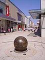 Globe in Kings Lynn.JPG 1,920 × 2,560; 1.19 MB
-
 Gone to lunch - geograph.org.uk - 208519.jpg 640 × 427; 70 KB
-
 Great Hollanden Farm Business Units - geograph.org.uk - 209996.jpg 640 × 480; 108 KB
-
 Great Holm Fire Station - geograph.org.uk - 208794.jpg 640 × 480; 122 KB
-
 Green lane - geograph.org.uk - 411172.jpg 640 × 448; 176 KB
-
 Guild hall in Kings Lynn 01.JPG 2,027 × 1,674; 739 KB
-
 Hall in Kings Lynn.JPG 1,606 × 2,068; 540 KB
-
 Hamish at Pool Farm - geograph.org.uk - 1028683.jpg 640 × 480; 158 KB
-
 Harvest at Westbrecks Farm - geograph.org.uk - 209243.jpg 640 × 427; 43 KB
-
 Harvested field - geograph.org.uk - 208693.jpg 640 × 427; 119 KB
-
 Headland east of Ivy Cove - geograph.org.uk - 208619.jpg 640 × 480; 107 KB
-
 Helenship Lane - geograph.org.uk - 209047.jpg 640 × 427; 60 KB
-
 Helland Bridge - geograph.org.uk - 1095392.jpg 640 × 480; 111 KB
-
 Hen-gae - geograph.org.uk - 214160.jpg 640 × 640; 158 KB
-
 Hermitage Water - geograph.org.uk - 209920.jpg 640 × 480; 109 KB
-
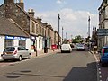 High Street, Tranent - geograph.org.uk - 208874.jpg 640 × 480; 71 KB
-
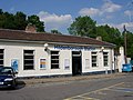 HildenboroughRailwayStation.jpg 640 × 480; 110 KB
-
 Holy Trinity Church Woolstone - geograph.org.uk - 208548.jpg 640 × 480; 152 KB
-
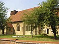 Holy Trinity Church, Woolstone - geograph.org.uk - 208547.jpg 640 × 480; 183 KB
-
 Honeybrook Farm - geograph.org.uk - 208920.jpg 640 × 480; 303 KB
-
 Hospital - geograph.org.uk - 208778.jpg 640 × 480; 91 KB
-
 House on Moor Lane - geograph.org.uk - 208725.jpg 640 × 480; 95 KB
-
 Humphrey Head - geograph.org.uk - 391037.jpg 640 × 480; 103 KB
-
 Humphrey Head Rams - geograph.org.uk - 452013.jpg 640 × 480; 78 KB
-
 In Rathen - geograph.org.uk - 220933.jpg 640 × 333; 132 KB
-
 Inchgalbraith, Loch Lomond.jpg 640 × 427; 83 KB
-
 Inner Portsoy Harbour - geograph.org.uk - 924354.jpg 640 × 480; 60 KB
-
 Kershope Burn - geograph.org.uk - 209043.jpg 640 × 480; 104 KB
-
 Kershope Burn, near Kershopehead - geograph.org.uk - 209056.jpg 640 × 480; 106 KB
-
 Kershope Forest - geograph.org.uk - 209053.jpg 480 × 640; 118 KB
-
 Kielder Forest - valley of the Neate Burn - geograph.org.uk - 209161.jpg 640 × 480; 119 KB
-

-
 Kielder Forest, near Willowbog - geograph.org.uk - 209627.jpg 640 × 480; 89 KB
-
 Kielder Viaduct - geograph.org.uk - 210198.jpg 480 × 640; 82 KB
-
 Killyhevlin Hotel - geograph.org.uk - 209971.jpg 640 × 480; 97 KB
-
 King Arthur's Labyrinth - geograph.org.uk - 212085.jpg 640 × 480; 138 KB
-
 King Street near Ancaster - geograph.org.uk - 208784.jpg 640 × 427; 60 KB
-
 St Margaret in Kings Lynn 01.JPG 1,920 × 2,560; 1.18 MB
-
 St Margaret in Kings Lynn 03.JPG 1,742 × 2,477; 1,011 KB
-
 St Margaret in Kings Lynn 04.JPG 1,964 × 1,691; 719 KB
-
 St Margaret in Kings Lynn 05.JPG 1,477 × 2,464; 783 KB
-
 St Margaret in Kings Lynn 07.JPG 1,716 × 2,262; 768 KB
-
 St Margaret in Kings Lynn 08.JPG 2,050 × 1,641; 566 KB
-
 Lake Vyrnwy (Llyn Efyrnwy) - geograph.org.uk - 347631.jpg 640 × 476; 135 KB
-
 Laneham harvest - geograph.org.uk - 209052.jpg 640 × 427; 70 KB
-
 Langold skatepark - geograph.org.uk - 1007115.jpg 640 × 480; 73 KB
-
 Larriston, Liddesdale - geograph.org.uk - 209939.jpg 640 × 480; 95 KB
-
 Leafy lane through Backpath Wood - geograph.org.uk - 208691.jpg 640 × 480; 341 KB
-
 Leaning Left And Right - geograph.org.uk - 210597.jpg 640 × 480; 105 KB
-
 Leaving Coneysthorpe - geograph.org.uk - 211034.jpg 640 × 480; 107 KB
-
 Legerwood - geograph.org.uk - 208856.jpg 640 × 480; 105 KB
-

-
 Liddel Water at Larriston - geograph.org.uk - 209937.jpg 480 × 640; 93 KB
-
 Liddesdale Parish Church, Saughtree - geograph.org.uk - 209947.jpg 640 × 480; 94 KB
-
 Ermine Street - geograph.org.uk - 208707.jpg 640 × 427; 92 KB
-
 Liscloon - geograph.org.uk - 209556.jpg 640 × 479; 44 KB
-
 Liscloon Post Office - geograph.org.uk - 209565.jpg 640 × 251; 32 KB
-
 Liscloon Upper - geograph.org.uk - 209553.jpg 640 × 479; 64 KB
-
 Lisnaragh Scotch Townland - geograph.org.uk - 209424.jpg 640 × 298; 28 KB


_-_geograph.org.uk_-_208473.jpg)


,_Roman_Camp_-_geograph.org.uk_-_1112459.jpg)


,_Shelf_-_geograph.org.uk_-_209561.jpg)


_-_geograph.org.uk_-_347631.jpg)


