Category:USGS topographic maps of Massachusetts
Jump to navigation
Jump to search
States of the United States: Alaska · California · Florida · Indiana · Massachusetts · Michigan · Nevada · New Jersey · New York · North Carolina · Pennsylvania · Utah · West Virginia · Wyoming
English: This category is exclusively for Large Public Domain digital images that are sourced or derivative of section or quadrant maps published in the public domain by the United States Geological Survey.
- Ideally, subcategories and maps in this schema which are not excerpts focused on narrow subject matters should conform in naming to the USGS MRC code identification numbering over a one degree by one degree section.
- The schema is an identification number, followed by an eight (rows, letters) by eight (cols, numbers) matrix coded A1 ... G8 (Organized: Lower East corner to Upper West corner)
- Some Older USGS maps should also be listed within: Category:Old maps of Massachusetts
Media in category "USGS topographic maps of Massachusetts"
The following 6 files are in this category, out of 6 total.
-
 1942 topographic map of Salem USGS.jpg 3,056 × 3,691; 4.62 MB
-
 Topographic maps of Spy Pond 1946.jpg 400 × 335; 88 KB
-
 Txu-pclmaps-topo-ma-salem-1886.jpg 2,941 × 3,556; 3.6 MB
-
 USGS Holyoke, MA 30 minute Quadrangle SE (1938).png 3,404 × 4,339; 8.92 MB
-
 USGS Holyoke, MA 30 minute Quadrangle SW (1938).png 3,409 × 4,348; 9.11 MB
-
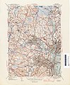
 USGS Lawrence, MA-NH 15 minute Quadrangle SE (1893).jpg 1,700 × 2,800; 1.31 MB


.png)
.png)
.jpg)