Category:Topographische Karte der Kreise des Regierungs-Bezirks Münster
Jump to navigation
Jump to search
Media in category "Topographische Karte der Kreise des Regierungs-Bezirks Münster"
The following 11 files are in this category, out of 11 total.
-
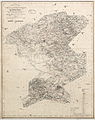
 Topographische Karte der Kreise des Regierungs-Bezirks Muenster, Blatt 01 - Kreis Ahaus, 1845.jpg 10,244 × 8,694; 23.07 MB
-

-

-
 Topographische Karte der Kreise des Regierungs-Bezirks Muenster, Blatt 05 - Kreis Coesfeld, 1847.jpg 8,262 × 10,425; 22.56 MB
-

-
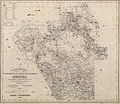
 Topographische Karte der Kreise des Regierungs-Bezirks Muenster, Blatt 06 - Kreis Muenster, 1842.jpg 8,831 × 10,421; 24.18 MB
-

-
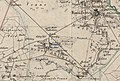 Ahlintel auf Topographische Karte Kreis Steinfurt, 1847.jpg 1,800 × 1,210; 577 KB
-
-

-


