Category:Road signs in Herefordshire
Jump to navigation
Jump to search
Ceremonial counties of England: Bedfordshire · Berkshire · Buckinghamshire · Cambridgeshire · Cheshire · Cornwall · Cumbria · Derbyshire · Devon · Dorset · Durham · East Riding of Yorkshire · East Sussex · Essex · Gloucestershire · Greater London · Greater Manchester · Hampshire · Herefordshire · Hertfordshire · Kent · Lancashire · Leicestershire · Lincolnshire · Merseyside · Norfolk · North Yorkshire · Northamptonshire · Northumberland · Nottinghamshire · Oxfordshire · Rutland · Shropshire · Somerset · South Yorkshire · Staffordshire · Suffolk · Surrey · Tyne and Wear · Warwickshire · West Midlands · West Sussex · West Yorkshire · Wiltshire · Worcestershire
City-counties: City of London
Former historic counties:
Other former counties:
City-counties: City of London
Former historic counties:
Other former counties:
Subcategories
This category has the following 7 subcategories, out of 7 total.
B
- Road signs in Bromyard (4 F)
F
L
- Road signs in Ledbury (7 F)
- Road signs in Leominster (4 F)
M
R
- Road signs in Ross-on-Wye (6 F)
S
Media in category "Road signs in Herefordshire"
The following 29 files are in this category, out of 29 total.
-
 "Ducks Crossing" sign, Symonds Yat - geograph.org.uk - 4184955.jpg 3,872 × 2,592; 4.14 MB
-
 30 mph limit across Garway Common - geograph.org.uk - 1181119.jpg 640 × 480; 394 KB
-
 A40 dual carriageway near Glewstone - geograph.org.uk - 1576474.jpg 640 × 480; 251 KB
-
 Abbeydore station site geograph-3221935-by-Ben-Brooksbank.jpg 2,347 × 1,322; 2.48 MB
-
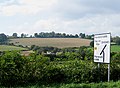 Arable hillside - geograph.org.uk - 977626.jpg 640 × 471; 138 KB
-
 AA Sign - geograph.org.uk - 539921.jpg 640 × 480; 110 KB
-

-
 Ducks Crossing at Symonds Yat East - geograph.org.uk - 1029734.jpg 480 × 640; 132 KB
-
 Ducks Crossing, Symonds Yat - geograph.org.uk - 2213844.jpg 2,616 × 3,488; 3.07 MB
-

-
 Henry Street Evangelical Church - geograph.org.uk - 754288.jpg 640 × 480; 170 KB
-
 It's all happening here - geograph.org.uk - 975651.jpg 480 × 640; 143 KB
-
 Horses, not heavies - geograph.org.uk - 947477.jpg 640 × 480; 105 KB
-
 Kington building overhang - 2015-07-15 - Andy Mabbett - 01.JPG 2,592 × 3,872; 2.74 MB
-
 Lane to Lewstone - geograph.org.uk - 1397823.jpg 640 × 480; 230 KB
-
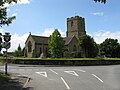 Lugwardine - Church From Lumber Lane - geograph.org.uk - 1355879.jpg 640 × 480; 163 KB
-
 Narrow road to Lewstone - geograph.org.uk - 1210532.jpg 640 × 426; 86 KB
-
 Newmarket Street subway - geograph.org.uk - 858069.jpg 640 × 480; 83 KB
-
 Ross Spur road sign - geograph.org.uk - 965070.jpg 640 × 380; 48 KB
-
 Single track road to Greenway Farm - geograph.org.uk - 757865.jpg 640 × 480; 143 KB
-
 Subway exit - geograph.org.uk - 1132232.jpg 480 × 640; 102 KB
-
 To Three Elms Trading Estate - geograph.org.uk - 904582.jpg 640 × 480; 123 KB
-
 Turn left here for Goodrich Castle - geograph.org.uk - 3874388.jpg 800 × 620; 160 KB
-
 Village store, Whitchurch - geograph.org.uk - 1203780.jpg 640 × 426; 68 KB
-
 Battered sign near Eccleswall Court - geograph.org.uk - 1652619.jpg 640 × 480; 146 KB
-
 Children - geograph.org.uk - 361266.jpg 480 × 640; 156 KB
-

-
 Free Range Notice - geograph.org.uk - 62428.jpg 640 × 479; 134 KB
-
 The Ledbury Bypass - geograph.org.uk - 657125.jpg 640 × 480; 174 KB


.jpg)