Category:Road maps of U.S. Highways in Michigan
Jump to navigation
Jump to search
States of the United States: Alabama · Arizona · Colorado · Connecticut · Florida · Georgia · Idaho · Illinois · Indiana · Iowa · Kansas · Louisiana · Maine · Maryland · Michigan · Nevada · New Jersey · New Mexico · New York · North Carolina · Ohio · Pennsylvania · South Carolina · Texas · Utah · Virginia · Wisconsin · Wyoming
Subcategories
This category has only the following subcategory.
Media in category "Road maps of U.S. Highways in Michigan"
The following 24 files are in this category, out of 24 total.
-
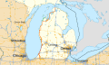
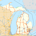 Michigan US Highways.svg 1,026 × 1,026; 3.89 MB
-
 US 2 MI map.svg 1,027 × 609; 918 KB
-
 US 2 near Manistique in 1936.jpg 370 × 319; 56 KB
-
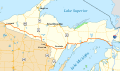
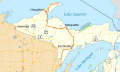
 US 8 map.svg 1,027 × 609; 1.37 MB
-
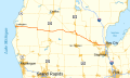 US 10 MI map.svg 1,027 × 609; 453 KB
-
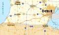 US 12 MI map.svg 1,027 × 609; 1.11 MB
-
 US 16 MI map.svg 1,026 × 608; 1 MB
-
 US 23 MI map.svg 1,027 × 609; 2.08 MB
-
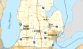
 US 24 MI map.svg 1,027 × 609; 616 KB
-
 US 25 MI map.svg 1,026 × 608; 5.94 MB
-
 US 27 MI map.svg 1,027 × 606; 1.83 MB
-
 US 31 MI map.svg 1,027 × 609; 2.76 MB
-
 US 33 MI map.svg 1,027 × 609; 705 KB
-
 Marquette, Michigan, 1927.jpg 484 × 695; 296 KB
-
 US 41 Dec 1937.png 711 × 539; 704 KB
-
 US 41 MI map.svg 1,027 × 609; 995 KB
-
 BUS 41 Marquette map.svg 1,027 × 609; 182 KB
-
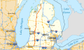
 US 45 MI map.svg 1,026 × 608; 1.14 MB
-
 US 127 MI map.svg 1,027 × 609; 1.72 MB
-
 US 131 map.svg 1,027 × 609; 2.22 MB
-
 US 141 map.svg 1,028 × 610; 2.48 MB
-
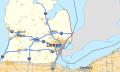
 U.S. 223 map.svg 1,027 × 609; 208 KB
-
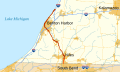
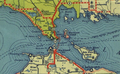 US 31 in 1936.png 757 × 467; 637 KB
-
 US Highways in Michigan 1926.png 1,237 × 1,261; 3.47 MB


