Category:Public transport maps of Brandenburg
Jump to navigation
Jump to search
Federal states of Germany:
Subcategories
This category has the following 2 subcategories, out of 2 total.
P
Media in category "Public transport maps of Brandenburg"
The following 41 files are in this category, out of 41 total.
-
 ÖPNV in der Region Berlin - Basiskarte.png 2,407 × 1,567; 1.45 MB
-
 HANS-Gesamtnetz 2016 08.png 902 × 571; 88 KB
-
 HANS-Gesamtnetz 2017 02.png 979 × 738; 81 KB
-
 ODEG BBSachsen 2008.jpg 963 × 1,207; 198 KB
-
 ODEG-Netz Dez2007.png 1,104 × 2,242; 292 KB
-
 ODEG-Netz Dez2008.png 1,104 × 2,242; 153 KB
-
 ODEG-Netz Jan2011.png 1,104 × 2,242; 157 KB
-
 ODEG-Netz Okt2011.png 1,104 × 2,242; 189 KB
-
 PEG-Berlin.png 970 × 1,097; 76 KB
-
 Rb11.svg 721 × 741; 83 KB
-
 Rb12.svg 721 × 741; 82 KB
-
 Rb13.svg 721 × 741; 80 KB
-
 Rb14.svg 721 × 741; 80 KB
-
 Rb19.svg 721 × 741; 82 KB
-
 Rb20.svg 721 × 741; 80 KB
-
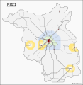 Rb21.svg 721 × 741; 81 KB
-
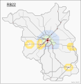 Rb22.svg 721 × 741; 81 KB
-
 Rb23.svg 721 × 741; 81 KB
-
 Rb24.svg 721 × 741; 81 KB
-
 Rb25.svg 721 × 741; 81 KB
-
 Rb26.svg 721 × 741; 82 KB
-
 Rb27.svg 721 × 741; 82 KB
-
 Rb31sachsen-anhalt.svg 721 × 741; 80 KB
-
 Rb31sachsen.svg 721 × 741; 80 KB
-
 Rb33.svg 721 × 741; 81 KB
-
 Rb34.svg 721 × 741; 80 KB
-
 Rb35.svg 721 × 741; 81 KB
-
 Rb43.svg 721 × 741; 81 KB
-
 Rb45.svg 721 × 741; 81 KB
-
 Rb46.svg 721 × 741; 80 KB
-
 Rb49.svg 721 × 741; 81 KB
-
 Rb51brb.svg 721 × 741; 83 KB
-
 Rb51sa.svg 721 × 741; 80 KB
-
 Rb54.svg 721 × 741; 81 KB
-
 Rb55.svg 721 × 741; 81 KB
-
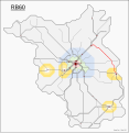 Rb60.svg 721 × 741; 83 KB
-
 Regionalverkehr berlin-brandenburg 16.svg 741 × 861; 390 KB
-
 Regionalverkehr berlin-brandenburg.svg 741 × 861; 385 KB
-
 Regionalverkehr brandenburg ebunternehmen 16.svg 741 × 861; 82 KB
-
 Vbb-map-2014.png 1,022 × 1,075; 199 KB
-
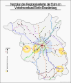
 Öffentliches Verkehrsnetz in Berlin und Brandenburg.png 1,280 × 1,394; 644 KB


