Category:Old maps of the province of Lugo
Jump to navigation
Jump to search
Subcategories
This category has only the following subcategory.
Media in category "Old maps of the province of Lugo"
The following 15 files are in this category, out of 15 total.
-
 Couto de Pácios de Pinheira (1583).jpg 1,891 × 2,048; 254 KB
-
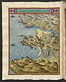
 Ria de Ribadeu no atlas de Pedro Teixeira (1634).jpg 8,904 × 11,117; 11.1 MB
-
 Rias de Viveiro e do Barqueiro no atlas de Pedro Teixeira (1634).jpg 8,908 × 11,119; 12.02 MB
-
 Ar.E-T.4-C.5 215.jpg 5,203 × 2,610; 1.56 MB
-

-
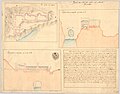
 Mapa do Caminho Real de Galiza entre Lugo e Betanços (1812) (1).jpg 1,931 × 1,280; 273 KB
-
 Mapa do Caminho Real de Galiza entre Lugo e Betanços (1812) (2).jpg 2,003 × 1,307; 348 KB
-
 Or-1-9.jpg 4,593 × 3,588; 1.57 MB
-
 Francisco Coello - Mapa de Lugo (mediados del siglo XIX).jpg 400 × 300; 186 KB
-
 T0001759 3.jpg 1,381 × 749; 362 KB
-
 T0001759 4.jpg 792 × 733; 295 KB
-
 T0001759.jpg 7,899 × 10,492; 19.31 MB
-
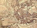
 Arredores da cidade de Lugo (1864).jpg 1,360 × 1,395; 1.57 MB
-
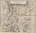
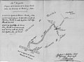 Croquis da linha de fronteira entre Pantom e Sober (1934).jpg 2,510 × 1,834; 609 KB
-
 Mapa de A Coruña i Astúries (AFCEC RIBASV D 4811).jpeg 980 × 768; 211 KB
.jpg)
.jpg)
.jpg)

.jpg)
_(1).jpg)
_(2).jpg)

.jpg)


.jpg)
.jpg)
.jpeg)