Category:Old maps of the Vatican City
Jump to navigation
Jump to search
Media in category "Old maps of the Vatican City"
The following 20 files are in this category, out of 20 total.
-
 Giovanni Battista Nolli-Nuova Pianta di Roma (1748) 01-12 - crop.JPG 2,973 × 1,372; 3.02 MB
-
 Giovanni Battista Nolli-Nuova Pianta di Roma (1748) 01-12.JPG 8,233 × 5,080; 16.78 MB
-
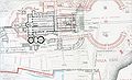
 MapOfBorgo.jpg 717 × 619; 154 KB
-
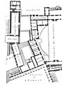
 Apostolic Palace (Lanciani).jpg 1,772 × 2,425; 2.99 MB
-
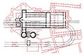
 Papal Basilica of Saint Peter (Lanciani).jpg 2,446 × 1,498; 1,004 KB
-
 How to See the Vatican, 1914 - Map of the Vatican.jpg 2,623 × 1,987; 1.97 MB
-

-
 337 of 'Rome, ancient and modern, and its environs' (11019953333).jpg 1,671 × 2,166; 946 KB
-
 GiardinoVaticano.JPG 1,861 × 2,017; 1.08 MB
-
 Giovanni Battista Nolli-Nuova Pianta di Roma (1748) 01-12 cropped.jpg 1,957 × 1,314; 1.05 MB
-
 Italy - handbook for travellers (1880) (14779893504).jpg 1,472 × 2,280; 523 KB
-
 PatriPetri.jpg 255 × 182; 13 KB
-
 Pianta delle Grotte Vaticane.jpg 1,414 × 2,136; 2.28 MB
-
 S. Peter, Rome, Italy. (2830834621).jpg 982 × 1,200; 462 KB
-
 S. Peter, Rome, Italy. (2830835203).jpg 1,200 × 894; 352 KB
-
 S. Peter, Rome, Italy. (2830835859).jpg 1,200 × 899; 909 KB
-
 S. Peter, Rome, Italy. (2831669714).jpg 1,200 × 885; 345 KB
-
 Vatican City annex.jpg 1,024 × 818; 318 KB
-
 Vatican City Map 1929.jpg 700 × 529; 134 KB
-
 ViaCorneliaVatican.JPG 736 × 493; 62 KB
_01-12_-_crop.JPG)
_01-12.JPG)

.jpg)
.jpg)

.jpg)
.jpg)

_01-12_cropped.jpg)
_(14779893504).jpg)


.jpg)
.jpg)
.jpg)
.jpg)


