Category:Old maps of Greifswald
Jump to navigation
Jump to search
Use the appropriate category for maps showing all or a large part of Greifswald. See subcategories for smaller areas:
| If the map shows | Category to use |
|---|---|
| Greifswald on a recently created map | Category:Maps of Greifswald or its subcategories |
| Greifswald on a map created more than 70 years ago | Category:Old maps of Greifswald or its subcategories |
| the history of Greifswald on a recently created map | Category:Maps of the history of Greifswald or its subcategories |
| the history of Greifswald on a map created more than 70 years ago | Category:Old maps of the history of Greifswald or its subcategories |
Media in category "Old maps of Greifswald"
The following 12 files are in this category, out of 12 total.
-
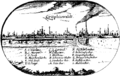
 Caspar Merian - Gryphiswaldia.jpg 1,462 × 997; 458 KB
-

-
 Führer durch Greifswald - 1886 - N004.jpg 3,044 × 2,545; 976 KB
-
 Greifswald 1659.jpg 3,100 × 2,487; 10.85 MB
-
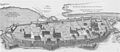 Greifswald im Mittelalter (Rekonstruktion Theodor Pyl).jpg 2,175 × 950; 981 KB
-
 Grundriss von Greifswald 1842 (Friedrich von Hagenow).jpg 2,204 × 1,790; 2.04 MB
-
 Karte des Deutschen Reiches (5820089c).jpg 10,745 × 9,390; 36.25 MB
-
 Karte von Greifswald um 1825 (Rückseite).tif 7,028 × 5,188; 4.93 MB
-
 Karte von Greifswald um 1825 (Vorderseite).tif 7,028 × 5,188; 6.36 MB
-
 Lubinus Grijphiswaldt.png 1,578 × 1,000; 50 KB
-
 Plattegrond van Greifswald, NG-1985-7-3-47.jpg 4,350 × 2,790; 1.13 MB
-
 Pommersches Landesmuseum Greifswald 11.jpg 3,345 × 1,816; 1.61 MB


.jpg)
.jpg)
.jpg)


