Category:Old maps of Bihar
Jump to navigation
Jump to search
States of India: Andhra Pradesh · Arunachal Pradesh · Assam · Bihar · Goa · Gujarat · Jharkhand · Karnataka · Kerala · Madhya Pradesh · Maharashtra · Manipur · Meghalaya · Odisha · Sikkim · Tamil Nadu · Telangana · Tripura · Uttar Pradesh · Uttarakhand · West Bengal
Union territories: Andaman and Nicobar Islands · Dadra and Nagar Haveli and Daman and Diu · Delhi · Jammu and Kashmir · Ladakh · Lakshadweep · Puducherry
Former states of India: Jammu and Kashmir ·
Former union territories: Daman and Diu ·
Union territories: Andaman and Nicobar Islands · Dadra and Nagar Haveli and Daman and Diu · Delhi · Jammu and Kashmir · Ladakh · Lakshadweep · Puducherry
Former states of India: Jammu and Kashmir ·
Former union territories: Daman and Diu ·
| NO WIKIDATA ID FOUND! Search for Old maps of Bihar on Wikidata | |
| Upload media |

Subcategories
This category has only the following subcategory.
Media in category "Old maps of Bihar"
The following 26 files are in this category, out of 26 total.
-
 1780 Bonne Map of Northern India - Geographicus - IndiaNorth-bonne-1780.jpg 3,500 × 2,345; 2.4 MB
-
 1786 - A map of Bengal, Bahar, Oude & Allahabad - James Rennell - William Faden.jpg 13,170 × 8,982; 84.18 MB
-

-
-
 Bodhgaya(1878) p283 T01.jpg 1,940 × 2,911; 1.7 MB
-
 Bodhgaya(1878) p289 T03.jpg 1,963 × 2,987; 1.72 MB
-
 Bodhgaya(1878) p291 T04.jpg 2,851 × 2,060; 2.24 MB
-
 Bodhgaya(1878) p293 T05.jpg 1,931 × 2,980; 2.52 MB
-
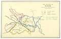 GRIERSON(1885) p008 MAP.jpg 2,445 × 1,571; 1.41 MB
-
 19s Bengal province map.jpg 1,080 × 1,080; 237 KB
-
 An actual survey, of the provinces of Bengal, Bahar &c. (1794) By Major James Rennell.jpg 9,227 × 6,134; 11.7 MB
-
 Barh.png 552 × 289; 357 KB
-
 Barhbuch.png 1,465 × 420; 360 KB
-
 Bihar and Orissa province.jpg 588 × 896; 71 KB
-
 Bihar-Orissa-Province.png 577 × 892; 818 KB
-
 Bihār. 7-69. LOC gm70003327.jpg 3,161 × 4,172; 1.68 MB
-
 Bihār. 7-69. LOC gm70003327.tif 3,161 × 4,172; 37.73 MB
-
-
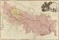
 Carte du Bihar p153.jpg 2,690 × 1,733; 1.73 MB
-
 Joppen1907BritishBengalBritishBurmaA.jpg 877 × 1,200; 238 KB
-
-
 Map of the Gangetic Plains circa. 1786.jpg 8,606 × 5,820; 7.1 MB
-
 Provincial Geographies of India Volume 2 0013.jpg 1,995 × 1,971; 681 KB
-
 Provincial Geographies of India Volume 2 0096.jpg 2,846 × 1,850; 2.31 MB
-
 South Bihar map by James Rennell.jpg 4,784 × 5,136; 2.56 MB
-
 Txu-oclc-6654394-ng-45-8th-ed.jpg 5,000 × 4,830; 10.14 MB


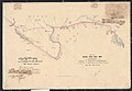
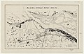
_1860_Sheet_No._5_Rough_Thak_Bust_Map_of_Boundary_between_Nepal_and_British_Territory.jpg)
_p283_T01.jpg)
_p289_T03.jpg)
_p291_T04.jpg)
_p293_T05.jpg)
_p008_MAP.jpg)

_By_Major_James_Rennell.jpg)


