Category:Maps showing 1864
Jump to navigation
Jump to search
| ← 1860 1861 1862 1863 1864 1865 1866 1867 1868 1869→ |
English: Maps showing the year 1864 (i.e. history maps)
See also category: 1864 maps. and 1860s maps for more maps showing this year usually created not long after the given year.
See also category: 1864 maps. and 1860s maps for more maps showing this year usually created not long after the given year.
Subcategories
This category has the following 4 subcategories, out of 4 total.
M
S
Media in category "Maps showing 1864"
The following 8 files are in this category, out of 8 total.
-
 Civilware.jpg 1,660 × 1,030; 164 KB
-
 CSS Shenandoah world travels 1865.png 3,830 × 2,218; 278 KB
-
 Delaware Presidential Election Results 1864.svg 744 × 744; 19 KB
-

-

-
 United States 1863-06-1864-05.png 1,000 × 677; 120 KB
-
 United States 1864-05-1864-10.png 1,000 × 677; 123 KB
-
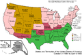 United States 1864-10-1865.png 1,000 × 677; 126 KB


_(14576063510).jpg)
_(14760353924).jpg)


