Category:Maps showing 1840
Jump to navigation
Jump to search
| ← 1840 1841 1842 1843 1844 1845 1846 1847 1848 1849→ |
English: Maps showing the year 1840 (i.e. history maps)
See also category: 1840 maps. and 1840s maps for more maps showing this year usually created not long after the given year.
See also category: 1840 maps. and 1840s maps for more maps showing this year usually created not long after the given year.
Subcategories
This category has only the following subcategory.
Media in category "Maps showing 1840"
The following 8 files are in this category, out of 8 total.
-
 BlankMap-World-1840.png 1,356 × 627; 20 KB
-
 Black Americans 1840 County.png 13,210 × 8,900; 5.51 MB
-
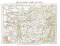
 Evariste Huc carte voyage.jpg 3,559 × 2,794; 2.1 MB
-
 Evariste Huc carte voyage.png 903 × 734; 677 KB
-
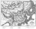
 Map of Tartary, Thibet, and China.png 2,951 × 2,262; 6.01 MB
-
 Political Evolution of Central America and the Caribbean 1840 na.png 1,000 × 750; 127 KB
-
 States under Muhammad ali's rule.jpg 500 × 481; 288 KB
-
 White Americans 1840 County.png 13,210 × 8,900; 5.42 MB


