Category:Maps of the province of Madrid
Jump to navigation
Jump to search
Provinces of Spain: Álava · Albacete · Alicante · Almería · Asturias‡ · Ávila · Badajoz · Balearic Islands‡ · Barcelona · Biscay · Burgos · Cáceres · Cádiz · Cantabria‡ · Castellón · Ciudad Real · Córdoba · A Coruña · Cuenca · Gipuzkoa · Girona · Granada · Guadalajara · Huelva · Huesca · Jaén · León · Lleida · Lugo · Madrid‡ · Málaga · Murcia‡ · Navarre‡ · Ourense · Palencia · Las Palmas · Pontevedra · La Rioja‡ · Salamanca · Santa Cruz de Tenerife · Segovia · Seville · Soria · Tarragona · Teruel · Toledo · Valencia · Valladolid · Zamora · Zaragoza · Autonomous cities: Ceuta · Melilla
‡: uniprovincial autonomous communities.
‡: uniprovincial autonomous communities.
Subcategories
This category has only the following subcategory.
Media in category "Maps of the province of Madrid"
The following 16 files are in this category, out of 16 total.
-
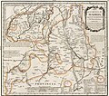 Tomás López de Vargas Machuca (1773) Mapa de la provincia de Madrid.jpg 3,623 × 3,200; 3.92 MB
-
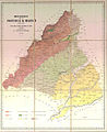
 Mapa de la provincia de Madrid 1868 (cropped).jpg 1,844 × 1,430; 302 KB
-
 Mapa de la provincia de Madrid 1868.jpg 5,096 × 3,864; 1.71 MB
-
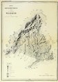 Mapa hisométrico de la provincia de Madrid-Facundo Cañada.pdf 1,239 × 1,739; 555 KB
-
 ATLAS JUSTUS PERTHES 03.jpg 4,525 × 3,941; 15.19 MB
-
 Benito Chias Carbó (1909) mapa de la Provincia de Madrid.png 2,864 × 3,706; 21.38 MB
-

-
 Corpo Truppe Volontarie 45.jpg 9,924 × 3,478; 17.89 MB
-

-
 Madrid mapa 1919.jpg 2,700 × 3,600; 12.69 MB
-
 Mapa de la provincia de Madrid.jpg 600 × 737; 101 KB
-

-

-
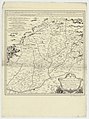 Mapa de las Cercanias de Madrid... - por ... Tomas López... - btv1b53226992g (1 of 2).jpg 5,362 × 7,194; 4.88 MB
-
 Provincia de Madrid loc 1590.svg 586 × 454; 635 KB
-
_Mapa_de_la_provincia_de_Madrid.jpg)
.jpg)


_mapa_de_la_Provincia_de_Madrid.png)

_Las_primeras_c%C3%A1maras_de_la_Regencia.png)


_Thomas_Lopez_-_btv1b53057042q.jpg)
.jpg)
