Category:Maps of the Moluccas
Jump to navigation
Jump to search
| NO WIKIDATA ID FOUND! Search for Maps of the Moluccas on Wikidata | |
| Upload media |
May only include maps that focus on the island of the Moluccas. If other major islands of Indonesia are visible, use other categories, such as Category:Maps of eastern Indonesia. If showing the location of the Moluccas in relation with Indonesia, use Category:Locator maps of the Moluccas. If not showing the whole of the Moluccas, use the province level category(/categories).

Subcategories
This category has the following 7 subcategories, out of 7 total.
!
*
M
Media in category "Maps of the Moluccas"
The following 7 files are in this category, out of 7 total.
-

-
 Karta ID Maluku isl.PNG 348 × 348; 4 KB
-
 Maluku Islands be.png 350 × 350; 11 KB
-
 Maluku Islands de.png 1,499 × 1,650; 1.08 MB
-
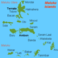
 Maluku Islands en.png 1,489 × 1,640; 1.08 MB
-
 Maluku Islands international.png 350 × 350; 7 KB
-
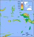 Maluku Locator Topography.png 1,567 × 1,688; 765 KB


