
Category:Maps of the Low Countries in the 10th century
English: This category is about non-contemporary maps showing historical territories of the Low Countries as they were in the 10th century.
Contemporary old maps belong into: Category:Old maps of the Netherlands and Category:Old maps of Belgium and the subcategories.
Contemporary old maps belong into: Category:Old maps of the Netherlands and Category:Old maps of Belgium and the subcategories.
Maps of the medieval Low Countries: (BCE) (CE) 5th century · 8th century · 9th century · 10th century · 11th century · 12th century · 13th century · 14th century · 15th century · 16th century · 17th century · 18th century ·
Media in category "Maps of the Low Countries in the 10th century"
The following 14 files are in this category, out of 14 total.
-
 62 of '(Histoire de la Belgique.)' (11109363496).jpg 1,541 × 2,574; 644 KB
-
 Bilderdijk 1000.jpg 1,455 × 1,545; 223 KB
-
 Lorena 870-segle XI.png 2,697 × 4,170; 1.99 MB
-
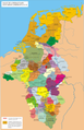
 Lotharingen-959 de.svg 585 × 752; 320 KB
-
 Lotharingen-959 ru.svg 585 × 752; 324 KB
-
 Lotharingen-959-hu.svg 585 × 752; 326 KB
-
 Lotharingen-959-ru.svg 594 × 761; 337 KB
-
 Lotharingen-959.svg 3,161 × 4,201; 598 KB
-
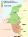
 Lotharingia-959 with current borders.svg 512 × 751; 416 KB
-
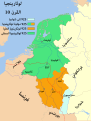 Lotharingia-959-ar.svg 3,161 × 4,174; 471 KB
-
 Lotharingia-959-el.png 454 × 599; 77 KB
-
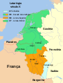
 Lotharingia-959-es.svg 3,273 × 4,208; 462 KB
-
 Lotharingia-959-pt.svg 3,161 × 4,174; 277 KB
-
 Lotharingia-959.svg 3,161 × 4,174; 547 KB
%27_(11109363496).jpg)


