Category:Maps of South Yorkshire
Jump to navigation
Jump to search
Wikimedia category | |||||
| Upload media | |||||
| Instance of | |||||
|---|---|---|---|---|---|
| Category combines topics | |||||
| South Yorkshire | |||||
county of England, UK      | |||||
| Instance of |
| ||||
| Location | Yorkshire and the Humber, England | ||||
| Capital | |||||
| Inception |
| ||||
| Population |
| ||||
| Area |
| ||||
| Different from | |||||
| official website | |||||
 | |||||
Subcategories
This category has the following 7 subcategories, out of 7 total.
Media in category "Maps of South Yorkshire"
The following 34 files are in this category, out of 34 total.
-
 Conisbrough - Doncaster dot.png 417 × 599; 122 KB
-
 Doncaster wards.png 1,027 × 646; 117 KB
-
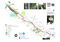
 Dunford Bridge Aerial (RLH).JPG 1,113 × 636; 674 KB
-
 England Police Forces (South Yorkshire).svg 1,108 × 1,345; 312 KB
-
 EnglandPoliceSouthYorkshire.png 2,165 × 2,670; 87 KB
-

-
 Location Map of the City of Sheffield.png 800 × 558; 421 KB
-
 Ordnance Survey 1-250000 - SE.jpg 4,000 × 4,000; 8.57 MB
-
 Ordnance Survey 1-250000 - SK.jpg 4,000 × 4,000; 9.31 MB
-

-
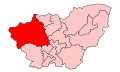 PenistoneStocksbridgeConstituency.svg 500 × 300; 30 KB
-
 River Sheaf Walk 2021-1.jpg 4,678 × 3,309; 1.05 MB
-
 S-York outline.png 800 × 558; 426 KB
-
 S-York.svg 1,129 × 1,385; 107 KB
-
 Sheffield UK ward map 2010 (blank).svg 1,425 × 996; 641 KB
-
 Sheffield UK ward map 2016 (blank).svg 1,425 × 996; 722 KB
-
 Sheffield UK ward map 2024.svg 1,425 × 996; 683 KB
-
 Sheffield-wards-Graves Park.png 580 × 408; 68 KB
-
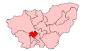 SheffieldBrightsideHillsboroughConstituency.svg 500 × 300; 30 KB
-
 South Yorkshire Combined Authority among combined authorities in England map, 2021.svg 1,152 × 1,152; 8.93 MB
-
 South Yorkshire County.png 3,358 × 2,138; 1.4 MB
-
 South Yorkshire numbered districts.svg 1,425 × 974; 556 KB
-
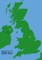
 South Yorkshire outline map with UK.png 800 × 558; 423 KB
-
 South Yorkshire Place Names.png 737 × 511; 386 KB
-
 South Yorkshire population density map, 2011 census.png 4,376 × 3,393; 10.88 MB
-
 South Yorkshire UK constituency map (blank).svg 1,425 × 974; 899 KB
-
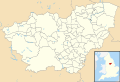
 South Yorkshire UK district map (blank).svg 1,425 × 974; 691 KB
-
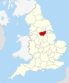
 South Yorkshire UK location map.svg 1,425 × 974; 1.47 MB
-
 South Yorkshire UK locator map 2010.svg 1,108 × 1,345; 302 KB
-
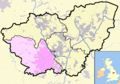
 South Yorkshire UK parish map (blank).svg 1,425 × 974; 1.27 MB
-
 South Yorkshire UK relief location map.jpg 1,999 × 1,366; 310 KB
-
 South Yorkshire UK ward map (blank).svg 1,425 × 974; 1.35 MB
-
 SouthYorkshireNumbered.png 200 × 127; 6 KB
-
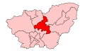 WentworthDearneConstituency.svg 500 × 300; 30 KB


.JPG)
.svg)


.svg)
.svg)
.svg)
.svg)
.svg)
.svg)