Category:Maps of Paris in the 1920s
Jump to navigation
Jump to search
Media in category "Maps of Paris in the 1920s"
The following 29 files are in this category, out of 29 total.
-
 "Americana Print- Map of Paris" Textile MET 68659.jpg 2,574 × 1,937; 871 KB
-
 Paris metro 192x.jpg 3,537 × 2,825; 4.04 MB
-

-
-
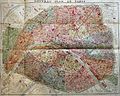
 1920 Robelin Map of Paris, France - Geographicus - Paris-robelin-1920.jpg 5,000 × 3,749; 14.88 MB
-

-
 Population density of Paris, 1921 - Demographia.svg 512 × 293; 185 KB
-

-
 Population density of Paris, 1926 - Demographia.svg 512 × 293; 184 KB
-
-

-
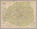
 1929 – Carte des Environs de Paris dans un rayon de 20 km. Taride.jpg 11,632 × 9,688; 20.73 MB
-
 Carte des environs de Paris avec les tramways de pénétration, 1925 - Stanford Libraries.jpg 17,296 × 13,357; 69.42 MB
-
 Carte industrielle de la région parisienne, 1927 - Bibliothèques spécialisées Paris.jpg 4,617 × 4,224; 4.1 MB
-
 Département de la Seine - Densité de la population, année 1921 - BHVP.jpg 1,740 × 1,438; 306 KB
-
 Département de la Seine - Densité de la population, année 1926 - BHVP.jpg 1,071 × 868; 84 KB
-
 Georges Peltier, Plan de Paris à vol d'oiseau, 1923 - Gallica.jpg 10,962 × 8,972; 28.62 MB
-
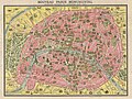
 Nouveau plan de Paris monumental by L. Guilmin, 1920 - Stanford Libraries.jpg 11,319 × 8,367; 16.86 MB
-
 Nouveau plan de Paris monumental by L. Guilmin, 1920 - Stanford Libraries.tif 11,319 × 8,367; 90.35 MB
-
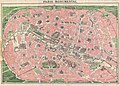
 Paris 1928 Theatres.jpg 1,204 × 1,028; 997 KB
-
 Plan commode de Paris métropolitain et nord-sud, 1925 - Stanford Libraries.jpg 17,311 × 13,396; 70.48 MB
-
 Plan de Paris divisé en 20 arrondissements. dressé par L. Guilmin, 1926 - Gallica.jpg 8,847 × 7,272; 15.14 MB
-
 Plan de Paris Métropolitain by A. Leconte - Stanford Libraries.jpg 11,940 × 9,313; 32.31 MB
-
 Plan de Paris à vol d'oiseau, dressé et dessiné par G. Peltier, 1920 - Gallica.jpg 14,094 × 11,305; 36.98 MB
-
 Plan de Paris à vol d'oiseau, dressé... par G. Peltier, 1926 - Gallica.jpg 9,448 × 8,016; 18.84 MB
-
 Plan des ligne d'autobus de Paris by A. Leconte - Stanford Libraries.jpg 11,908 × 9,212; 29.67 MB
-
 Plan du métropolitain et du Nord-Sud. Maison Banno. Paris-Building - Gallica.jpg 9,080 × 6,107; 9.06 MB
-
 Plan d’ensemble de Paris et de son enceinte en 1920- Archives nationales- F-2-2712.jpg 7,667 × 7,557; 27.1 MB
-


_-_Geographicus_-_Paris-leconte-1820.jpg)


