Category:Maps of Landkreis Celle
Jump to navigation
Jump to search

| NO WIKIDATA ID FOUND! Search for Maps of Landkreis Celle on Wikidata | |
| Upload media |
Subcategories
This category has the following 3 subcategories, out of 3 total.
Media in category "Maps of Landkreis Celle"
The following 6 files are in this category, out of 6 total.
-
 CE in Niedersachsen.svg 1,121 × 978; 147 KB
-
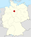
 Lage des Landkreises Celle in Deutschland.PNG 176 × 234; 5 KB
-
 Locator map CE in Germany.svg 1,075 × 1,273; 535 KB
-
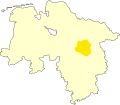
 Locator map CE in Lower Saxony.svg 1,424 × 1,203; 322 KB
-
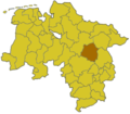 Lower saxony ce.png 280 × 245; 13 KB
-
 Nordburg bei der Aller (evtl. Mundburg).png 1,488 × 1,282; 1.16 MB


.png)