
Category:Maps of Kreis Soest
Deutsch: Maps des Kreises Soest
Wikimedia category | |||||
| Upload media | |||||
| Instance of | |||||
|---|---|---|---|---|---|
| Category combines topics | |||||
| Soest | |||||
district in North Rhine-Westphalia, Germany    | |||||
| Audio | |||||
| Instance of | |||||
| Named after | |||||
| Location | Arnsberg Government Region, North Rhine-Westphalia, Germany | ||||
| Capital | |||||
| Head of government |
| ||||
| Population |
| ||||
| Area |
| ||||
| Elevation above sea level |
| ||||
| Replaces | |||||
| official website | |||||
 | |||||
Subcategories
This category has the following 9 subcategories, out of 9 total.
Media in category "Maps of Kreis Soest"
The following 21 files are in this category, out of 21 total.
-
 Boker-Heide-Kanal Verlauf.svg 2,854 × 968; 51 KB
-
 DB 1760 railway map.png 1,500 × 1,106; 2.4 MB
-
 DB 2103 railway map.png 1,419 × 1,051; 1.71 MB
-
 DB 2930 railway map.png 1,566 × 1,102; 1.82 MB
-
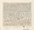 Karte des Deutschen Reiches - 356 - Soest (1902).jpg 7,449 × 6,467; 18.06 MB
-
 Lage des Kreises Soest in Deutschland.PNG 197 × 235; 3 KB
-
 Locator map SO in Germany.svg 1,075 × 1,273; 637 KB
-
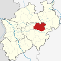 Locator map SO in North Rhine-Westphalia.svg 657 × 656; 479 KB
-
 Municipalities in SO.svg 580 × 395; 570 KB
-
 North rhine w so grey.png 593 × 585; 70 KB
-
 North rhine w so.png 263 × 245; 39 KB
-
 North rhine w SO.svg 660 × 660; 221 KB
-
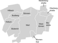
 Ortsteile Lippetal.png 711 × 466; 55 KB
-
 Ortsteile von Lippetal.png 734 × 575; 81 KB
-
 Ortsteile von Möhnesee mit Hauptort Körbecke.png 722 × 547; 86 KB
-
 Ortsteile von Rüthen.png 666 × 1,035; 95 KB
-
 Ortsteile von Welver.png 732 × 721; 107 KB
-
 Ortsteile von Werl.png 721 × 541; 63 KB
-
 Trotzbach Flusssystem.jpg 756 × 724; 432 KB
-
 Werl Ortsteile berichtigt.png 724 × 565; 74 KB
-
 Wickede Ortsteile.png 718 × 960; 65 KB


.jpg)


