Category:Maps of Eswatini
Jump to navigation
Jump to search
Countries of Africa: Algeria · Angola · Benin · Botswana · Burkina Faso · Burundi · Cameroon · Cape Verde · Central African Republic · Chad · Comoros · Democratic Republic of the Congo · Republic of the Congo · Djibouti · Egypt‡ · Equatorial Guinea · Eritrea · Eswatini · Ethiopia · Gabon · The Gambia · Ghana · Guinea · Guinea-Bissau · Ivory Coast · Kenya · Lesotho · Liberia · Libya · Madagascar · Malawi · Mali · Mauritania · Mauritius · Morocco · Mozambique · Namibia · Niger · Nigeria · Rwanda · São Tomé and Príncipe · Senegal · Seychelles · Sierra Leone · Somalia · South Africa · South Sudan · Sudan · Tanzania · Togo · Tunisia · Uganda · Zambia · Zimbabwe
Limited recognition: Ambazonia · Azawad · Puntland · Sahrawi Arab Democratic Republic · Somaliland – Other areas: Canary Islands · Ceuta · Madeira · Mayotte · Melilla · Réunion · Saint Helena, Ascension and Tristan da Cunha · Scattered Islands in the Indian Ocean · Western Sahara
‡: partly located in Africa
Wikimedia category | |||||
| Upload media | |||||
| Instance of | |||||
|---|---|---|---|---|---|
| Category combines topics | |||||
 | |||||
Subcategories
This category has the following 18 subcategories, out of 18 total.
B
- Maps of borders of Eswatini (2 F)
C
E
- ECHO Daily Maps of Eswatini (5 F)
F
L
- Location maps of Eswatini (4 F)
M
O
P
R
S
T
V
- Vegetation maps of Eswatini (3 F)
Pages in category "Maps of Eswatini"
The following 2 pages are in this category, out of 2 total.
Media in category "Maps of Eswatini"
The following 15 files are in this category, out of 15 total.
-
 ECHO Swaziland Editable A4 Landscape.pdf 1,754 × 1,239; 265 KB
-
 ECHO Swaziland Editable A4 Landscape.png 1,123 × 794; 294 KB
-
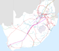 Electrical Power Grid - South Africa.png 4,092 × 3,528; 1.63 MB
-
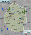
 Essuatíni.png 704 × 630; 92 KB
-
 Eswatini Regions map.png 2,000 × 2,289; 13.12 MB
-
 FLII Eswatini.png 808 × 822; 480 KB
-
 Location Eswatini.png 250 × 115; 5 KB
-
 Map of the topographic zones in Eswatini.png 643 × 794; 1.46 MB
-
 Mbabane coordi.jpg 408 × 499; 50 KB
-
 Natal province - descriptive guide and official hand-book (1911) (14574073508).jpg 4,016 × 2,760; 1.8 MB
-
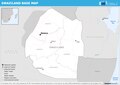
 Swaziland Base Map.png 1,104 × 691; 282 KB
-
 Swaziland Population Density, 2000 (5457626394).jpg 2,396 × 3,100; 534 KB
-
 Swaziland Population Density, 2000 (6171919191).jpg 2,322 × 3,160; 536 KB
-
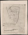 Swaziland-Transvaal-Portuguese East Africa Boundary Dispute (WOMAT-AFR-TRA-45-1-1).jpg 4,735 × 5,964; 13.6 MB
-
 Swaziland-Transvaal-Portuguese East Africa Boundary Dispute (WOMAT-AFR-TRA-45-1-2).jpg 4,719 × 6,048; 16.31 MB


_(14574073508).jpg)

.jpg)
.jpg)
.jpg)
.jpg)