Category:Maps of Southern Africa
Jump to navigation
Jump to search
Wikimedia category  | |||||
| Upload media | |||||
| Instance of | |||||
|---|---|---|---|---|---|
| Category combines topics | |||||
| Southern Africa | |||||
southernmost region of the African continent   | |||||
| Instance of | |||||
| Part of | |||||
| Location | Africa, Southern Hemisphere | ||||
| Has part(s) | |||||
| Different from | |||||
 | |||||
Subcategories
This category has the following 13 subcategories, out of 13 total.
A
B
E
L
M
N
S
Z
Media in category "Maps of Southern Africa"
The following 32 files are in this category, out of 32 total.
-
 Africa-countries-southern.svg 384 × 420; 26 KB
-
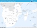
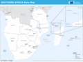
 Base Map of Southern Africa.png 1,344 × 871; 381 KB
-
 Bioregions of southern Africa Map, Legend, Caption.jpg 1,516 × 1,883; 842 KB
-
 Bioregions of southern Africa Map, Legend.jpg 1,270 × 1,715; 744 KB
-
 Bioregions of southern Africa Map.jpg 1,220 × 950; 459 KB
-
 BLS states.png 1,716 × 1,792; 123 KB
-
 Cənubi afrika 1.jpg 780 × 676; 100 KB
-
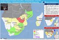 ECDM 20180313 Southern Africa Extended Dryness Food Insecurity.pdf 1,625 × 1,125; 697 KB
-
 ECHO Southern Africa Editable A3 Landscape.pdf 2,100 × 1,575; 486 KB
-
 ECHO Southern Africa Editable A3 Landscape.png 1,344 × 1,008; 353 KB
-
 Hilfe gmt beispiel afrika animation.gif 625 × 550; 549 KB
-
 Hilfe gmt beispiel afrika.jpg 1,250 × 940; 468 KB
-
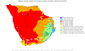 Koppen-Geiger Map Southern Africa future.svg 1,420 × 850; 1.17 MB
-
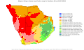 Koppen-Geiger Map Southern Africa present.svg 1,420 × 850; 1.25 MB
-
 Lisboa IMG 7469 (20932427628).jpg 5,616 × 3,744; 3.44 MB
-
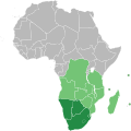
 LocationSouthernAfrica.png 359 × 359; 8 KB
-
 Political map of Southern Africa mk.svg 1,200 × 1,230; 63 KB
-
 SAF MAP.png 6,300 × 7,000; 1.92 MB
-
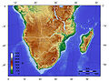
 Southern Africa altitudes.svg 800 × 835; 399 KB
-
 Southern Africa Map B1.jpg 1,600 × 1,166; 471 KB
-
 Southern Africa new map (fr).png 2,000 × 1,204; 574 KB
-
 Southern Africa new map (ru).png 2,000 × 1,204; 569 KB
-
 Southern Africa new map ka.svg 2,001 × 1,204; 107 KB
-
 Southern Africa new map uk.png 2,001 × 1,205; 411 KB
-
 Southern Africa new map uk.svg 2,001 × 1,204; 101 KB
-
 Southern Africa new map.png 2,000 × 1,204; 771 KB
-
 Southern Africa new map.svg 918 × 553; 1.48 MB
-
 Southern Africa regions map (cs).png 1,875 × 1,128; 656 KB
-
 Southern Africa small.svg 4,213 × 2,980; 1.8 MB
-
 Southern African Development Community.svg 1,000 × 1,000; 184 KB
-
 Southern African Map.svg 400 × 477; 32 KB
-
 Southern-Africa.svg 1,200 × 1,230; 55 KB


.jpg)


.png)
.png)


.png)


