Category:Maps of EPA ecoregions
Jump to navigation
Jump to search
Subcategories
This category has the following 3 subcategories, out of 3 total.
Media in category "Maps of EPA ecoregions"
The following 84 files are in this category, out of 84 total.
-
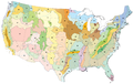 Level III ecoregions, United States.png 1,600 × 1,012; 791 KB
-
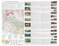
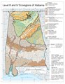 Alabama Level IV ecoregions.pdf 1,275 × 1,650; 604 KB
-
 Arizona Level IV ecoregions.pdf 6,900 × 5,400; 25.32 MB
-
 Arkansas Valley ecoregion, Level III.png 203 × 127; 25 KB
-
 AZ NM ecoregions.gif 462 × 381; 25 KB
-
 AZ NM ecoregions.png 462 × 381; 111 KB
-
 Boston Mountains ecoregion, Level III.png 150 × 99; 15 KB
-
 Central Basin and Range ecoregion.png 310 × 273; 40 KB
-
 Colorado Level IV ecoregions.pdf 6,652 × 5,260; 2.48 MB
-
 Colorado Plateau ecoregion map.jpg 440 × 473; 140 KB
-
 Columbia Level III ecoregions, Pacific Northwest.png 900 × 762; 214 KB
-
 Crosstimbermap.png 300 × 300; 28 KB
-
 DC-DE-MD-PA-VA-WV Level IV ecoregions.pdf 5,100 × 6,300; 2.34 MB
-
 East Central Texas Ecoregions.gif 573 × 801; 104 KB
-
 East Central Texas Ecoregions.png 573 × 801; 403 KB
-
 Florida EPA level IV ecoregions map.pdf 1,650 × 1,275; 818 KB
-
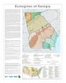 Georgia Level IV ecoregions small.pdf 3,450 × 4,350; 1.29 MB
-
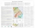 Georgia Level IV ecoregions.pdf 6,300 × 5,100; 1.45 MB
-
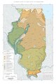 Il map.pdf 2,887 × 4,339; 1.35 MB
-
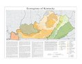 Kentucky Level IV ecoregions.pdf 4,800 × 3,750; 1.41 MB
-
 Klamath ecoregion California.gif 784 × 1,324; 167 KB
-
 Klamath ecoregion Oregon.gif 1,042 × 1,138; 126 KB
-
 Level III ecoregions, Pacific Northwest.gif 900 × 968; 68 KB
-
 Level III ecoregions, Pacific Northwest.png 900 × 968; 208 KB
-
 Level III ecoregions, United States - Oklahoma.png 368 × 207; 66 KB
-
 Level III ecoregions, United States Central Hardwood Region.png 1,600 × 1,012; 550 KB
-
 Level III ecoregions, United States, Arkansas.png 224 × 212; 42 KB
-
 Level IV ecoregions, Arkansas Valley.png 1,214 × 428; 269 KB
-
 Level IV ecoregions, Arkansas.pdf 6,750 × 5,402; 2.96 MB
-
 Level IV ecoregions, Blue Mountains.png 1,179 × 838; 719 KB
-
 Level IV ecoregions, Cascades.gif 544 × 1,654; 226 KB
-
 Level IV ecoregions, Cascades.png 544 × 1,654; 752 KB
-
 Level IV ecoregions, Coast Range.gif 631 × 1,945; 230 KB
-
 Level IV ecoregions, Coast Range.png 631 × 1,945; 750 KB
-
 Level IV ecoregions, Columbia Plateau.gif 1,221 × 1,312; 351 KB
-
 Level IV ecoregions, Columbia Plateau.png 1,221 × 1,312; 735 KB
-
 Level IV ecoregions, Eastern Cascades.png 604 × 1,678; 748 KB
-
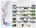
 Level IV ecoregions, Iowa and Missouri.pdf 6,900 × 5,400; 5.66 MB
-
 Level IV ecoregions, Klamath Mountains.png 502 × 577; 196 KB
-
 Level IV ecoregions, Mississippi Valley Loess Plains.png 288 × 794; 243 KB
-
 Level IV ecoregions, Nebraska and Kansas.pdf 6,654 × 5,264; 3.36 MB
-
 Level IV ecoregions, North Cascades.PNG 657 × 417; 356 KB
-
 Level IV ecoregions, Northern Basin and Range.png 2,184 × 1,018; 1.28 MB
-
 Level IV ecoregions, Ouachita Mountains.png 967 × 324; 171 KB
-
 Level IV ecoregions, Pacific Northwest.png 2,090 × 2,208; 4.81 MB
-
 Level IV ecoregions, Snake River Plain.png 1,479 × 802; 875 KB
-
 Level IV ecoregions, Willamette Valley.png 390 × 738; 266 KB
-
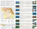
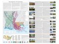 Louisiana Level IV ecoregions.pdf 7,200 × 5,400; 15.46 MB
-
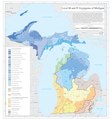 Michigan EPA ecoregions Levels III and IV.pdf 4,500 × 4,800; 4.35 MB
-
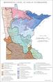 Minn ecoregionsmap.pdf 1,612 × 2,512; 613 KB
-

-
 Mississippi Alluvial Plain ecoregion map.png 2,550 × 3,300; 1.68 MB
-
 Mississippi Alluvial Plain Level IV ecoregions.pdf 6,652 × 5,260; 9.19 MB
-
 Mississippi Valley Loess Plains ecoregion map.png 2,550 × 3,300; 1.55 MB
-
 Nevada ecoregion map.gif 1,434 × 2,065; 481 KB
-
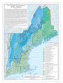 New England Level IV ecoregions.pdf 2,850 × 3,750; 1.94 MB
-
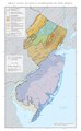 New Jersey Level IV ecoregions.pdf 2,400 × 3,900; 664 KB
-
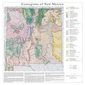 New Mexico EPA ecoregions.pdf 3,600 × 3,600; 3.18 MB
-
 New York Level III and Level IV ecoregions.pdf 7,200 × 5,550; 21.51 MB
-
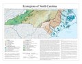 North Carolina Level IV ecoregions.pdf 3,600 × 2,812; 674 KB
-
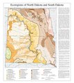 North Dakota South Dakota Level III and Level IV ecoregions USEPA.pdf 3,600 × 4,050; 977 KB
-
 Ohio Indiana Level IV ecoregions.pdf 3,750 × 3,450; 1.05 MB
-
 Oklahoma Level IV ecoregions.pdf 6,675 × 5,354; 15.71 MB
-
 Ozark Highlands ecoregion, Level III.png 244 × 185; 40 KB
-
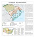 South Carolina Level IV ecoregions.pdf 2,925 × 3,075; 970 KB
-
 South Central Plains ecoregion, Level III.png 340 × 274; 77 KB
-
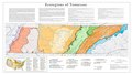 Tennessee Level IV ecoregions.pdf 5,400 × 3,000; 1.65 MB
-
 Texas ecoregions.gif 444 × 429; 22 KB
-
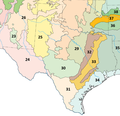 Texas ecoregions.png 444 × 429; 117 KB
-
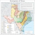 Texas Level IV ecoregions.pdf 3,604 × 3,604; 782 KB
-
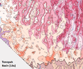 TonopahBasin.png 753 × 625; 240 KB
-
 Upper Midwest ecoregions.gif 585 × 343; 29 KB
-
 Upper Midwest ecoregions.png 585 × 343; 125 KB
-
 US South Central Plains ecoregion map.png 3,300 × 2,550; 1.53 MB
-
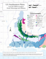 US Southeastern Plains ecoregion map - Detail of Mississippi and Alabama.png 2,550 × 3,300; 1.66 MB
-
 US Southeastern Plains ecoregion map - Detail of Virginia and the Carolinas.png 2,550 × 3,300; 2.37 MB
-
 US Southeastern Plains ecoregion map.png 3,300 × 2,550; 2.1 MB
-
 US Southern Coastal Plain ecoregion map - Detail of Big Bend Marsh.png 3,300 × 2,550; 756 KB
-
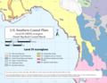
 US Southern Coastal Plain ecoregion map.png 3,300 × 2,550; 1.23 MB
-
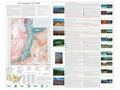 Utah Level IV ecoregions.pdf 7,200 × 5,400; 6.32 MB
-
 Western Corn Belt Plains ecoregion, Level III.png 403 × 334; 81 KB
-
 Western Gulf Coastal Plain ecoregion map.png 3,300 × 2,550; 1.49 MB
-
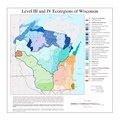 Wi eco lg.pdf 3,300 × 3,300; 740 KB
-
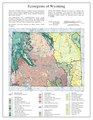 Wyoming Level IV ecoregions.pdf 1,275 × 1,650; 477 KB


