File:Arizona Level IV ecoregions.pdf
Jump to navigation
Jump to search

Size of this JPG preview of this PDF file: 766 × 599 pixels. Other resolutions: 307 × 240 pixels | 613 × 480 pixels | 981 × 768 pixels | 1,280 × 1,002 pixels | 2,560 × 2,003 pixels | 6,900 × 5,400 pixels.
Original file (6,900 × 5,400 pixels, file size: 25.32 MB, MIME type: application/pdf)
Captions
Captions
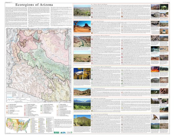
map of Arizona showing ecoregions
Summary
[edit]| Description |
English: Map of Level III and Level IV ecoregions in the U.S. state of Arizona, as defined by the U.S. Environmental Protection Agency |
| Date | |
| Source | ftp://newftp.epa.gov/EPADataCommons/ORD/Ecoregions/az/az_front.pdf via https://www.epa.gov/eco-research/ecoregion-download-files-state-region-9#pane-02 |
| Author | Griffith, G.E., Omernik, J.M., Johnson, C.B., and Turner, D.S. |
Licensing
[edit]This image (or other media) is a work of an Environmental Protection Agency employee, taken or made as part of that person's official duties. As works of the U.S. federal government, all EPA images are in the public domain.
|
||
File history
Click on a date/time to view the file as it appeared at that time.
| Date/Time | Thumbnail | Dimensions | User | Comment | |
|---|---|---|---|---|---|
| current | 00:30, 15 February 2021 |  | 6,900 × 5,400 (25.32 MB) | TimK MSI (talk | contribs) | Uploaded a work by Griffith, G.E., Omernik, J.M., Johnson, C.B., and Turner, D.S. from ftp://newftp.epa.gov/EPADataCommons/ORD/Ecoregions/az/az_front.pdf via https://www.epa.gov/eco-research/ecoregion-download-files-state-region-9#pane-02 with UploadWizard |
You cannot overwrite this file.
File usage on Commons
There are no pages that use this file.