Category:Maps of Douglas County, Colorado
Jump to navigation
Jump to search
Counties of Colorado: Adams · Alamosa · Arapahoe · Archuleta · Baca · Bent · Boulder · Chaffee · Cheyenne · Clear Creek · Conejos · Costilla · Crowley · Custer · Delta · Dolores · Douglas · Eagle · El Paso · Elbert · Fremont · Garfield · Gilpin · Grand · Gunnison · Hinsdale · Huerfano · Jackson · Jefferson · Kiowa · Kit Carson · Lake · La Plata · Larimer · Las Animas · Lincoln · Logan · Mesa · Mineral · Moffat · Montezuma · Montrose · Morgan · Otero · Ouray · Park · Phillips · Pitkin · Prowers · Pueblo · Rio Blanco · Rio Grande · Routt · Saguache · San Juan · San Miguel · Sedgwick · Summit · Teller · Washington · Weld · Yuma
City-counties: Broomfield · Denver
City-counties: Broomfield · Denver
Wikimedia category | |||||
| Upload media | |||||
| Instance of | |||||
|---|---|---|---|---|---|
| Category combines topics | |||||
| Douglas County | |||||
county in Colorado, United States   | |||||
| Instance of | |||||
| Named after | |||||
| Location | Colorado | ||||
| Capital | |||||
| Inception |
| ||||
| Population |
| ||||
| Area |
| ||||
| official website | |||||
 | |||||
Subcategories
This category has only the following subcategory.
O
Media in category "Maps of Douglas County, Colorado"
The following 50 files are in this category, out of 50 total.
-

-
 Colorado Senate District 30 (2010).png 3,507 × 2,490; 411 KB
-
 Colorado Senate District 4 (2010).png 3,507 × 2,490; 412 KB
-
 COMap-doton-Franktown.PNG 300 × 216; 13 KB
-
 COMap-doton-LoneTree.PNG 300 × 216; 13 KB
-
 COMap-doton-Louviers.PNG 300 × 216; 13 KB
-
 COMap-doton-Parker.PNG 300 × 216; 13 KB
-
 COMap-doton-Sedalia.PNG 300 × 216; 13 KB
-
 COMap-doton-ThePinery.PNG 300 × 216; 13 KB
-
 COMap-doton-Westcreek.PNG 300 × 216; 13 KB
-
 COMap-locationof-Aurora.PNG 800 × 579; 83 KB
-

-

-
-

-

-
-

-

-

-

-

-

-

-

-

-

-
-

-

-

-

-

-

-

-

-

-

-

-

-

-

-

-

-

-

-

-

-

-
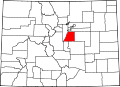 Map of Colorado highlighting Douglas County.svg 1,558 × 1,128; 64 KB

.png)
.png)


