Category:Maps of 4th-century Scotland
Jump to navigation
Jump to search
![]() Scotland 301-400 CE: Maps showing all or a substantial part of the territory of Scotland as it was in the 4th century.
Scotland 301-400 CE: Maps showing all or a substantial part of the territory of Scotland as it was in the 4th century.
| Preceded by: Maps of 3rd-century Scotland |
Maps of 4th-century Scotland 301- 400 CE |
Succeeded by: Maps of 5th-century Scotland |
Media in category "Maps of 4th-century Scotland"
The following 7 files are in this category, out of 7 total.
-
 C. 350 Roman Empire.jpg 4,117 × 3,031; 3.44 MB
-
 C. 395 Roman Provinces.jpg 1,774 × 1,385; 3.03 MB
-
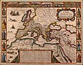 A New Map of The Roman Empire, 1651.jpg 6,230 × 4,867; 5.73 MB
-
 Butler Britania.jpg 2,022 × 2,506; 1.69 MB
-
 End.of.Roman.rule.in.Britain.383.410.jpg 2,582 × 3,220; 1,010 KB
-
 North.Sea.Periphery.250.500.jpg 2,031 × 2,463; 820 KB
-
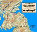 Roman.Scotland.370.jpg 2,211 × 1,877; 497 KB


